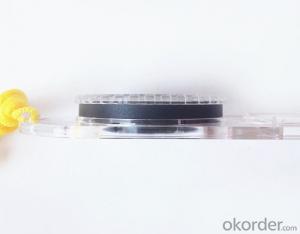


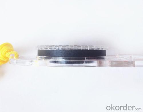


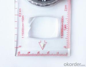
Professional Map or Ruler Mini-Compass DC47-2 for Surveying
- Ref Price:
-

- Loading Port:
- Tianjin
- Payment Terms:
- TT OR LC
- Min Order Qty:
- 20 pc
- Supply Capability:
- 10000 pc/month
OKorder Service Pledge
OKorder Financial Service
You Might Also Like


Features of DC47-2
1, professional usage: orientation, distance measuring, measuring slope, azimuth and pitching Angle measurement, drawing, a magnifying glass
2, high quality compass with neck rope, portable and rugged
3, ACRYLIC material, about 2mm thick
4, Damping Dial: to keep the stability of the pointer, more suitable for outdoor environment.
5, Accuracy: accurate and clear, there were 360 degrees azimuth Angle, outer ring is 64-00 system, Liquid filled in the compass for reliable readings.
6, Magnifier function
5,ruler compass,
6,for map measure and drawing
7,one meter neck rope,
8,Liquid filled in the compass for reliable readings,
9, magnifier function.
Product details of DC47-2
Model: DC47-2
Name: Professional map compass, ruler compass
Product Origin: China
Supply Ability: 10,000 pcs/month
Minimum Order: 20 pcs
MOQ for OEM package: 500pcs
Product Size: 125.5*60.5*10 (mm)
- Q: Handheld GPS how to achieve decimeter
- Hello A GPS is not up to the requirements of the class, if no one can buy that expensive submeter GPS, currently on the market with the best precision is GPS, is Derek GARMIN this year a new eTrex 10, 20 and 30, the three can be reached within 3 meters accuracy, you can look at
- Q: Can you buy a good handheld GPS in China? FiveTrouble master recommended several professional handheld GPS brand, in addition to handheld GPS can speed it? Thank you!!
- If it is used, there is no difference.
- Q: I am ready to go to the field to go to college, but I do not know how to buy a handheld GPS, I hope you recommend. The most important thing is easy to carry.
- Is not a professional geography or geological personnel, there is no need to use Garmin ah Magellan what ah, you do not need. Using a mobile phone that can accept GPS signals is enough, free software and maps can be found on the internet. On the market a lot of 2000 yuan or so of the phone has this feature, remember that the phone has GPS signal acceptance, not GPRS oh!
- Q: Jia Ming etre20 handheld GPS good
- Jia Ming eTrex 20 has an enhanced 2.2 inch screen, a color rendering effect of 65 thousand TFT, a readable display in the sun. Durable waterproof, but also upgraded the interface to retain the existing hardness and toughness, to withstand dust, dirt, moisture and water erosion, these are not the legendary navigator opponent.
- Q: What is GPS Mu meter ah, with the general said that the GPS measuring instrument what is the difference?
- If it's just a GPS meter and a GPS meter, that's a thing.If the measuring instrument, it is not the same with the measured mu instrument.In fact, these GPS is actually said handheld gps.It is used in measuring area and used in agriculture, forestry and animal husbandry.Handheld GPS generally have the function of measuring area.For example, Magellan, Gao Tianxiang handheld GPS etc. These are very famous, each model has the function of measuring areaWe have some stores!
- Q: Verify the accuracy of the GPS device to buy back, the way is to use Android under the'gps state 'software, to test the accuracy of real-time single point positioning.1 with two sets of the same Android Tablet Computer (custom machine, type of bad) in the same position for receiving, find that the accuracy is the same (software, are 1-2 meters), but the position would be poor 10 meters or more. It's in the same place.The 2 one is the Android tablet computer, a mobile phone is HTC G10, also received together in the same position, find that the accuracy is not the same as (the latter 20 meters or so), but also may be about 10 meters position difference.The accuracy of this GPS device can reach 1-2 meters, while the same location in real-time single point positioning error of 10 meters, a reasonable explanation.
- Oh the single point positioning accuracy is about 10 meters, but also have a great relationship with the environment around you, if in the city, the accuracy of twenty meters are possible, if the open place, outside. Ten meters should not be a problem. Whether you use a professional measurement RTK or ordinary navigation handheld machine, single point positioning accuracy can reach 1-2 meters of the machine I is not met, if you see where I wish to share with me, thank you. Can only say that the use of professional measurement RTK will certainly be higher than the navigation accuracy of GPS single point oh
- Q: How do I still stay in the GPS navigation, GPS monitoring of the primary idea? FiveBusiness services, thank you!Future business services
- 1 power, telecommunications, telecommunications and other network time synchronization2 accurate timing of admission3 accurate frequency of admission1 geodetic measurements of various levels2 Road and various line lofting3 underwater topographic survey4 crustal deformation measurement, dam and large building deformation monitoring5.GIS application6 construction machinery (tyre crane, bulldozer, etc.) control7 precision agricultureAt the present stage, it is mainly used for the security of vehicles and the management of personnel vehicles. With the continuous development of social economy, more and more vehicle users, GPS will gradually get wide application, on the stage of the car is enough for your service. Prospects can still be Lin Shijie GPS
- Q: How to use the handheld GPS whole watershed investigation
- The critical value is an object from a physical state to another physical state, a physical quantity to meet the conditions, which is equivalent to the stagnation point in Mathematics
- Q: Fuxin coordinates with the mapping of the seven parameters are what ah there is no professional knowledge to tell my brother I need to fill the gps... Thanks.
- Handheld GPS has not been used, you can find three known control points, try to solve.
- Q: I just bought a handheld GPS Magellan No. 1, showing the latitude and longitude coordinates, I want to set the geodetic coordinates of latitude and longitude, do not know where to set, I would like to ask you, how to set, there is a better picture shows the best, thank you so much.Magellan GPS 210 is not 2000 shy
- Latitude and longitude is the geodetic coordinates, the landlord said to be set up for the use of the projection plane Cartesian coordinates - Beijing 54 or Xi'an, the 80 plane rectangular coordinates it.1 position: [format setting unit - "[] position display format is set to User UTM Grid, and enter the relevant parameters, such as the 3 degree or 6 degree with the area with the central meridian projection, the ratio was 1, that deviation is 500000m, north-south deviation is 0.
Send your message to us
Professional Map or Ruler Mini-Compass DC47-2 for Surveying
- Ref Price:
-
- Loading Port:
- Tianjin
- Payment Terms:
- TT OR LC
- Min Order Qty:
- 20 pc
- Supply Capability:
- 10000 pc/month
OKorder Service Pledge
OKorder Financial Service
Similar products


Hot products


Hot Searches

