
GIS V2
- Ref Price:
-

- Loading Port:
- China Main Port
- Payment Terms:
- TT OR LC
- Min Order Qty:
- -
- Supply Capability:
- -
OKorder Service Pledge
OKorder Financial Service
You Might Also Like


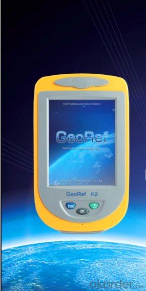
V2 series, a professional high-performance GIS data collector, applies advanced high-accuracy differential augmentation algorithm to provide post-processing enhanced differential function. With high-end mainstream hardware configurations, GeoRef V2 series supports large-size raster image data (up to 10GB) loading and 100 megabyte (MB) level vector data loading, and helps you achieve higher accuracy and better resolution for various applications in an effective and reliable way.
GeoRef V2 series, which is compatible with the international main-stream GIS platforms especially KQ GIS, offers overall GPS/GIS solution. Furthermore, KQ GEO could also offer users customized applications and functions to meet different requirements.
High-level System Configuration
◆ Industry-grade integrated design
◆ Windows CE 6.0 operating system
◆ 1GHz industry-grade mobile processor
◆ 256/512MB memory, 512MB flash memory
Integrated both Survey and Navigation GPS Receivers
◆ Integrated high-accuracy survey GPS receiver
◆ Integrated high-performance navigation GPS receiver
◆ Support SBAS (WAAS, EGNOS, MSAS)
◆ Built-in high-sensitive and anti-jamming GPS antenna
Integrated 2G/3G Wireless Communication
◆ Built-in industry-grade 2G/3G wireless communication modem
◆ Achieve high-accuracy positioning result by directly receiving differential data from reference station (CORS)
◆ Support data exchange between the server center and mobile GPS terminal
Integrated Bluetooth and WiFi Wireless Communications
◆ Built-in Bluetooth and WiFi wireless communication modems
◆ Stable short distance wireless data transmission
Integrated 3D Electronic Compass
◆ Effective assistance to GPS fieldwork
◆ High-speed and high-accuracy A/D conversion
◆ Zero pointing correction
Industry-grade Design
◆ Industry-grade integrated design with multi-functions
◆ IP67 waterproof and dustproof design against 1.5m natural drop
Visual Digital Image
◆Built-in high resolution camera supports on-site image acquisition and annotation
◆ Automatically matching GPS coordinates with image attributes
◆ Built-in microphone supports on-site audio acquisition and annotation
Professional Fieldwork Collection Software
GeoPac is the latest multifunctional GNSS data collection, processing and management software, containing data collection, edition, detection, analysis and storage, which is widely applied in different fields such as land supervision, water census, forestry inspection and etc.
◆ Comprehensive functionalities, meeting both requirements of high-accuracy engineering survey and field data collection.
◆ High-accuracy rapid positioning, meeting different accuracy requirements.
◆ User-friendly interface makes heavy-duty fieldwork easy and convenient.
◆ Universal coordinate systems with the popular Gauss, UTM, Mercator projection, etc.
◆ Various convenient coordinate transformation tools, making plane 4-parameter, spatial 7-parameter and 3-parameter transformation easier.
◆ Multiple professional data collection methods.
◆ Complete attributes library and easy setup make data collection, edition and management super-easy, greatly increasing fieldwork efficiency
- Q: What is GPS Mu meter ah, with the general said that the GPS measuring instrument what is the difference?
- The amount of words on the handheld GPS, Magellan can be both economic and affordable.
- Q: Handheld GPS which brand is good
- Now GPS can also do handheld measurement accuracy, precision can usually reach decimeter level, the industry there are relatively well-known Huace, professional GPS measurement instrument, high precision of handheld GPS the good.
- Q: What do you need to test for GPS?
- 3 positioning time this means when you restart your GPS receiver, it determines the time required for the current position. For the 12 channel receiver, if you are in the last position near the location of the cold start time is 30 seconds to 5 minutes, hot start is usually 5 to 40 seconds, and for the 2 channel receiver, most of the cold start more than 15 minutes, hot start 2 to 5 minutes. The positioning accuracy of the positioning accuracy of 4 which is obtained in the case of no WAAS/EGNOS conclusion, rather than most of the GPS receiver specification of the positioning accuracy, can look at the test report of others so before the purchase of GPS, now on the market with 12 channel GPS receiver error level is generally not more than 30 meters, height error not more than 50 meters, the average error is about 15 meters. Due to the use of the module, our product positioning error is about 10 meters,
- Q: In addition to the parameters, that is the problem of the machine, what method can reduce the error of these two machines to a minimum. Because, at the same time to find a coordinate. The gap is too big.
- GPS was in error with 10 meters, with the star search results, related to the environment, if the precision is high, as long as the use of handheld GPS submeter or handheld RTK
- Q: Fuxin coordinates with the mapping of the seven parameters are what ah there is no professional knowledge to tell my brother I need to fill the gps... Thanks.
- XYZ offset, XYZ twist, 6, plus a scaling factor.Seven parameters have to be calculated, or from the local surveying and mapping departments to.
- Q: The navigation module it is "selph" three generation? Another one I mainly use it to measure the land area, easy to use, the error is not big?I want to buy Magellan 500 do not know whether it is good to use
- Can only use professional GPS measuring instrument! Magellan and SIBAO!
- Q: How to hand GPS eTrex H data to the computer
- "Shaanxi skmax navigation information Limited" GARMIN proxy (GARMIN official website can be found), contact (Xiao Hou) the hope can help to you, if you do not understand what we see on the Internet, may at any time, contact us!
- Q: Ask how to select a google satellite map into a handheld Area GPS
- If it refers to a professional portable handheld GPS, please ignore this answer.
- Q: Handheld GPS, the measurement of arable land, fixed point and circle test, which is more accurate,
- So for you to measure the area, some of the 3cm point error surrounded by the graphics area and some millimeter level point error surrounded by the graphics area is not much difference.
- Q: What qualifications should a normal GPS locator have?
- You ask is handheld GPS, it is the manufacturer's qualification requirements or what. For example, business license, tax registration certificate, organization code certificate, vendor authorization, software copyright, precision test report, 3C certificate, ISO9001, industrial grade IP certificate and other relevant qualification certificates and documents
Send your message to us
GIS V2
- Ref Price:
-
- Loading Port:
- China Main Port
- Payment Terms:
- TT OR LC
- Min Order Qty:
- -
- Supply Capability:
- -
OKorder Service Pledge
OKorder Financial Service
Similar products


Hot products


Hot Searches

