
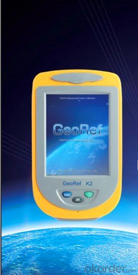
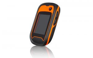
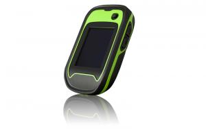
GIS K2
- Ref Price:
-

- Loading Port:
- China Main Port
- Payment Terms:
- TT OR LC
- Min Order Qty:
- -
- Supply Capability:
- -
OKorder Service Pledge
OKorder Financial Service
You Might Also Like

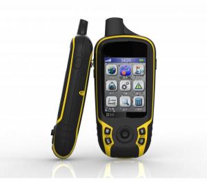
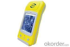
GeoRef K2 series is a high-sensitive GIS data collector specially designed for the industrial professionals. It offers overall GNSS/GIS solutions, which is compatible with the international main-stream GIS platforms especially KQ GIS, while supporting large-size raster image data (up to 10GB) and hundred megabyte level vector data loading. GeoRef K2 series, with independent intellectual property, offers high-accuracy real-time differential and kinematic survey for post-processing. Based on Windows CE operating system, KQ GEO can offer users customized applications or functions according to different requirements. GeoRef K2 series, even mini-size, lightweight but rugged, is suitable for complicated environment.
Advanced System Configuration
◆ Windows CE 6.0 operating system
◆1GHz industrial processor
◆ 256MB/512MB massive storage, 512MB flash memory
◆ 3.5 inches professional sunlight-readable color touch screen
◆ 3.7V, 4200mAh long-life Li-Ion battery, up to 8h continuous working with one battery
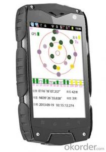
Professional GPS Functions
◆ 50-channels+ L1C/A
◆ Support SBAS (WAAS, EGNOS, MSAS, GAGAN)
◆ Built-in high-sensitive and anti-jamming GPS antenna
Integrated 2G/3G Wireless Communication
◆ Industrial 2G/3G wireless communications modem
◆ Data exchanging between the server center and the mobile GPS terminal
◆ Convenient for task assignment, online monitoring, data uploading, and rapid decision-making
Integrated Bluetooth and WiFi Wireless Communications
◆ Built-in Bluetooth and WiFi wireless communication modem
◆ Stable short distance wireless data transmission
Integrated 3D Electronic Compass
◆ Effective assistance to the GPS fieldwork
◆ High-speed and high-accuracy A/D conversion
◆ Zero pointing correction
Industrial Design
◆ Industrial integrated multi-functions
◆ IP67, waterproof and dustproof, against 1.5m natural falling
◆ For high-standard vehicle navigation GPS
Visual Digital Image
◆Built-in high resolution camera supports on-site image acquisition and annotation
◆ Automatically matching GPS coordinates with image attributes
◆ Built-in microphone supports on-site audio acquisition and annotation
Professional Fieldwork Collection Software
GeoPac is the latest multifunctional GNSS data collection, processing and management software, containing data collection, edition, detection, analysis and storage, which is widely applied in different fields such as engineering survey, road engineering, water conservancy, forestry and etc.
◆ Comprehensive functionalities, meeting both requirements of high-accuracy engineering survey and field data collection.
◆ High-accuracy rapid positioning, meeting different accuracy requirements.
◆ User-friendly interface makes heavy-duty fieldwork easy and convenient.
◆ Universal coordinate systems with the popular Gauss, UTM, Mercator projection, etc.
◆ Various convenient coordinate transformation tools, making plane 4-parameter, spatial 7-parameter and 3-parameter transformation easier.
◆ Multiple professional data collection methods.
◆ Complete attributes library and easy setup make data collection, edition and management super-easy, greatly increasing fieldwork efficiency.
- Q: Reversing camera can be mounted to the portable navigation device on Careland
- However, the portable Kay Car Navigator, not a whole machine, portable navigator device itself is likely for not providing video interface to install reversing camera.Hope to help you, hope to adopt!
- Q: Portable navigator remove the built-in battery, powered by cigarette lighter, there can not be star search, enter the navigation page after the card or crash, sometimes the screen image is not steady, car is not good, what is going on, how to solve? After a 12V to 36V wide voltage charger or the like
- Navigator wood in the side, open the navigation page directly to the screen, simply can not run the navigation programChasing the answerHello, this should be voltage instability, there may be a problem with the screen.
- Q: What brand of portable navigator
- No need to buy Portable navigation. Portable map updates slow and upgrade maps also charges.
- Q: Portable navigation with AV interface can be connected to the camera image
- There is a video input interface can be connected to the rear camera with the camera, there is no use
- Q: What is the difference between a GPS navigator and a portable navigator?
- The biggest difference is a high-grade one not high
- Q: Portable navigation sucker is always out of
- You can change the owner of the suction cup can be made of rubber or hard to change in the hope that I would like to help you wish you a happy [car questions asked the division of 4S professional technicians to solve 10 minutes]
- Q: Portable navigation Kay map with what version?
- PND is PDA + GPS means, C-Car car exclusive navigation version, does not support the use of portable navigation and mobile phones, so you should download the PND version
- Q: How to use handheld GPS locator
- Now the accuracy can reach 30 cm. The latitude and longitude of the WGS84 coordinates.
- Q: Portable navigation built-in hard disk or a good memory card
- These are not the memory card, but also cheap.Navigation does not require speed
- Q: Handheld GPS what brand of good quality?
- Please find the way to swim GPS use free installation, many types, small size, high positioning accuracy, large battery capacity. Private me
Send your message to us
GIS K2
- Ref Price:
-
- Loading Port:
- China Main Port
- Payment Terms:
- TT OR LC
- Min Order Qty:
- -
- Supply Capability:
- -
OKorder Service Pledge
OKorder Financial Service
Similar products


Hot products
Hot Searches

