
Surveying GIS K9
- Ref Price:
-

- Loading Port:
- China Main Port
- Payment Terms:
- TT OR LC
- Min Order Qty:
- -
- Supply Capability:
- -
OKorder Service Pledge
OKorder Financial Service
You Might Also Like


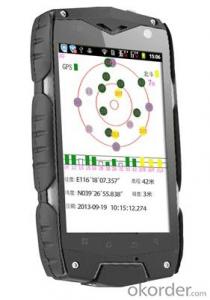
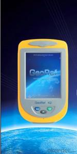
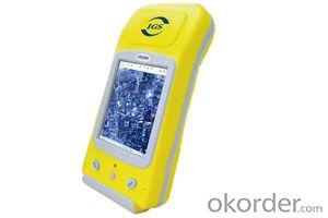
PJK 8 is a GPS data collection devices based with smart tablet Android operating system; 3.5 Cunban through the half- screen which is visible under bright light , high-resolution , ultra-thin , rugged design, easy to complete the wild variety of environments data collection ; built-in 3G data acquisition allows interaction within and outside the industry that has quickly realized .
Product Features
1, the basic functions
Operating system : Android 4.0, massive applications at your fingertips
Processor : 1GHZ processor speed
Memory capacity RAM: 512MB ROM: 4G
Memory card : MicroSD (TF) card , up to 32GB
2 , data collection
Data acquisition system with professional mobile GIS data collection , field mapping, waypoint storage coordinates to calculate the length , angle , and other areas of field measurement data , with a key two-coordinate conversion function .
3, GPS features
Differential : Support SBAS (MSAS, WAAS, EGNOS)
Real-time differential :1-3m
Single precision :3-5m
4 , communication performance
Built-in GSM and WCDMA communications , high-speed data transfer easy , can support voice calls
Bluetooth : 2.1 + EDR
WIFI: Support 802.11 Wireless LAN
USB: 2.0
5, the extended application
5 million pixel camera , 300,000 auto-focus camera ,
Video capture,
Built-in microphone supports voice attribute collection
Built-in electronic compass ,
Under no circumstances can indicate GPS direction , support multiple GPS intelligent navigation software
Support for emergency lighting and portrait and landscape screen automatically switches .
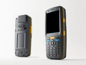
1, the physical properties of
Size : 125 * 65.5 * 20.5MM
Weight : 204G
Working temperature: -20 to 65 degrees
Storage temperature : -40 ℃ ~ 70 ℃
Humidity : 100 % non-condensing
Waterproof and dustproof : IP67
Anti- fall drop : Anti 1.5 meters free fall
Roll : Roll 1000 0.5 m height
Rugged and lightweight : GE Industrial grade high fire-retardant materials plus lightweight structure designed to allow field operations no longer be a burden.
2 , the display characteristics
Display: 3.5 -inch
Type: Multi -point capacitive touch screen
Brightness: anti-glare display, highlight
Resolution : 320 × 480
3, the power characteristics
Battery : 2000mAH Lithium Battery
Working hours : 10 hours of continuous work
4 ,Quality Certification
Product complies with EU CE, ROSH standards, China 's national quasi- GB 21288-2007 requirements
- Q: Handheld GPS locator measuring accuracy is about how many meters?
- The handheld machine precision is generally divided into: centimeter decimeter level, 1 meters, 2 meters, 3 meters, 5 meters; the precision is higher, the higher the price. You can consult the Haida official website "mobile MGIS mall".
- Q: I am ready to go to the field to go to college, but I do not know how to buy a handheld GPS, I hope you recommend. The most important thing is easy to carry.
- At present, the formal channels genuine licensed not so cheap, some refurbished machines may have. The cheapest machines now have about 900-1000!
- Q: Can a handheld navigator connect a cell phone? Thank you
- Open the phone hotspot WiFi, handheld navigator connected to this wifi.
- Q: What is the difference between professional GPS handsets and mobile navigation?
- GPS is the most important positioning accuracy. Professional handheld machine with industrial design. First of all, if used outdoors, then fell, and so on are likely to water, and this thing is also very expensive, so the opportunity to have a high professional anti shock waterproof performance.
- Q: Mountaineering to buy a professional GPS or Mountaineering Watch
- There is no need to buy too many devices. Now the phone is an essential tool, the phone has GPS,
- Q: Hand held GPS coordinate conversion method
- By the 84 coordinates to Beijing 54 Coordinate. A collection of application area of high grade control data in GPS receiver applied earth area (such as a county) find three (or more) uniform grade (accuracy better) or GPS "B" dot, point the best is around without interference of electromagnetic wave, vision, satellite signal. To the local surveying and mapping management department (such as: the local bureau of Surveying and mapping, surveying and Mapping Institute) Gauss plane coordinate copy these points of the Beijing 54 Coordinate System (x, y), the elevation of H and WGS-84 coordinates of the geodetic coordinates (B, L), the high H.
- Q: Professional handheld GPS GARMIN (DR) how to use
- Handheld GPS purposes, the measurement of soil area, linear navigation, auxiliary fishing waypoint navigation point information, traffic data display, such as the use of functional machines should be used manual
- Q: How do I still stay in the GPS navigation, GPS monitoring of the primary idea? FiveBusiness services, thank you!Future business services
- 1 power, telecommunications, telecommunications and other network time synchronization2 accurate timing of admission3 accurate frequency of admission1 geodetic measurements of various levels2 Road and various line lofting3 underwater topographic survey4 crustal deformation measurement, dam and large building deformation monitoring5.GIS application6 construction machinery (tyre crane, bulldozer, etc.) control7 precision agricultureAt the present stage, it is mainly used for the security of vehicles and the management of personnel vehicles. With the continuous development of social economy, more and more vehicle users, GPS will gradually get wide application, on the stage of the car is enough for your service. Prospects can still be Lin Shijie GPS
- Q: Welcome to make comments on the existing GPS tour pal what shortcomings to answer the more detailed the better
- Fifth elements: the terrain map is the main project of outdoor sports climbing, mountain climbing is very exhausting, we usually do a plan will be completed on schedule, a good plan should be to our destination in the manual run out before. And if you want to do this, it must be on the road difficult to have a correct anticipation. But this time, with the terrain map GPS can come in handy, the mountains and the altitude of the understanding, we need to know about these sections spend much time and energy. And the general GPS map, is unable to meet the needs. So we'd better buy a map with contour terrain data of professional grade GPS, make your own outdoor journey do in our hands.
- Q: In addition to the parameters, that is the problem of the machine, what method can reduce the error of these two machines to a minimum. Because, at the same time to find a coordinate. The gap is too big.
- GPS was in error with 10 meters, with the star search results, related to the environment, if the precision is high, as long as the use of handheld GPS submeter or handheld RTK
Send your message to us
Surveying GIS K9
- Ref Price:
-
- Loading Port:
- China Main Port
- Payment Terms:
- TT OR LC
- Min Order Qty:
- -
- Supply Capability:
- -
OKorder Service Pledge
OKorder Financial Service
Similar products

Hot products


Hot Searches

