


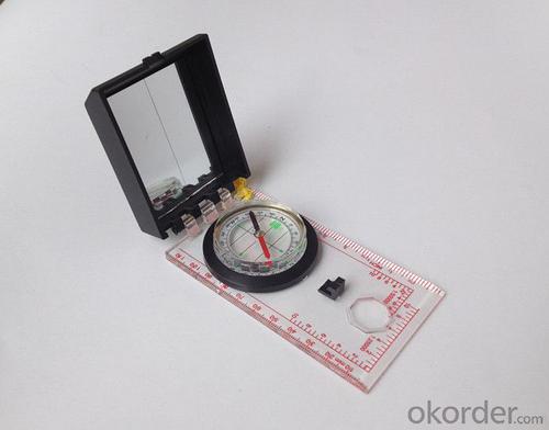


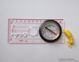
Transparant Map Scale Compass DC45-6
- Ref Price:
-

- Loading Port:
- China Main Port
- Payment Terms:
- TT OR LC
- Min Order Qty:
- -
- Supply Capability:
- -
OKorder Service Pledge
OKorder Financial Service
You Might Also Like


Model: DC45-6A
Name: Professional map compass, ruler compass
Product Origin: China
Supply Ability: 10,000 pcs/month
Minimum Order: 50 pcs
MOQ for OEM package: 500pcs
Product Size: 122*64*22 (mm)
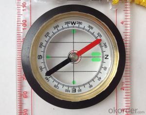
Features
1, professional usage: orientation, distance measuring, measuring slope, azimuth and pitching Angle measurement, drawing, a magnifying glass
2, high quality compass with neck rope, portable and rugged
3, ACRYLIC material, about 2mm thick
4, Damping Dial: to keep the stability of the pointer, more suitable for outdoor
environment.
5, Accuracy: accurate and clear, there were 360 degrees azimuth Angle, outer ring is 64-00 system, Liquid filled in the compass for reliable readings.
6, Magnifier function
- Q: What is the difference between industrial GPS handset and mobile navigation
- 5, strong battery life, is a major feature of professional GPS, Garmin handset General of dry batteries can be used more than ten hours, while the mobile phone GPS on GPS also can use a few hours, if you open the GPS in general about 3 hours will be over.6, supporting different software. Professional GPS handheld opportunities related to the PC end of the data processing software, this software can achieve the acquisition of data processing, as well as the application of data collection. The phone GPS can only navigation, and navigation is only a small part of the GPS function.I simply say these, this is my personal summary of the difference, if you have what is not clear can exchange. Want to help you.
- Q: Mobile GPS can replace professional handheld GPS
- No, professional signal and positioning more accurate,Walk along the plots in a circle can measure the size and graphics trajectory, 550 yuan, USB charging, large capacity lithium battery, black and white screen to see the clear day for outdoor use.
- Q: Verify the accuracy of the GPS device to buy back, the way is to use Android under the'gps state 'software, to test the accuracy of real-time single point positioning.1 with two sets of the same Android Tablet Computer (custom machine, type of bad) in the same position for receiving, find that the accuracy is the same (software, are 1-2 meters), but the position would be poor 10 meters or more. It's in the same place.The 2 one is the Android tablet computer, a mobile phone is HTC G10, also received together in the same position, find that the accuracy is not the same as (the latter 20 meters or so), but also may be about 10 meters position difference.The accuracy of this GPS device can reach 1-2 meters, while the same location in real-time single point positioning error of 10 meters, a reasonable explanation.
- You are very normal, the tablet computer and mobile phone antenna, not inside, the highest accuracy is about 10 meters, as ordinary navigation is good enough, to achieve centimeter level accuracy by GPS single is, that is to achieve the RTK measurement, is the application of professional measurement, now RTK or by the United States GPS satellite, not the United States GPS satellite as China Beidou mobile station and the base station is in need of mutual difference calculation to achieve accurate measurement. Now the single can receive SBAS signal, single precision up to 1-2 meters, the Northeast in some places to achieve sub meter level, which is the highest single precision can reach, is also used in field investigation using professional machine.
- Q: GPS handheld function to measure it?
- If the construction survey is certainly not the case, the control measurement is possible
- Q: What is the difference between a hand-held GPS and a car's onboard navigator
- As the first floor of a friend to answer the same, the general application of hand-held devices in land surveying, mountain climbing and other precise positioning when measuring the use of. Long standby time, three good performance. Easy to carry. A single charge can be used for a long time (depending on the machine). Although navigation, but the map is not detailed. At the same time, there is an opportunity to have latitude, latitude and other information.The car navigation is designed for users to drive out, in the field when not familiar with the road, ah, not familiar with the surrounding buildings, such as parking, hospitals, restaurants, gas stations. Used. Map details. But does not provide information such as latitude accuracy. No elevation.Look what you're doing. There is also a mobile phone navigation function.If you are purely for entertainment, then choose the phone.If you want to navigate in the car, select the vehicle navigation.If you are a very professional outdoor sports enthusiasts on the choice of handheld.
- Q: How to use the handheld GPS whole watershed investigation
- The critical value is an object from a physical state to another physical state, a physical quantity to meet the conditions, which is equivalent to the stagnation point in Mathematics
- Q: How about the accuracy of the GPS handset?
- So the selection depends on your needs the function and budget. Haida official website mall "mobile MGIS mall".
- Q: How to upgrade handheld navigator
- Hello to the brand's official website to download the latest map copy to memory card on the lineI wish you a pleasant car!
- Q: How the German born handheld GPS Mu meter, I want to buy?
- The data acquisition function of scientific, simple and accurate measurement of area, display area and the "Mu", "price" area can be set automatically calculate the area of "price", fit the actual demand Chinese industry users on the data collection and usage, highlighting the professional quality.Is the highest cost-effective mid-range machine
- Q: What is the difference between professional navigation and professional GPS navigator
- 1 high precision, good signal.Now GPS hardware precision is about 10 meters, the difference should be small. The accuracy of the practical application is also affected by the electronic map software. Signal does have good or bad, mainly in the fast positioning is not fast, stable, etc..2 long standby time, voice prompt.Standby time mainly to consider two factors. First, the battery capacity is large, two is the best battery is replaceable. PDA class GPS and vehicle navigation generally have voice prompts. This voice prompt is realized by navigation software.
Send your message to us
Transparant Map Scale Compass DC45-6
- Ref Price:
-
- Loading Port:
- China Main Port
- Payment Terms:
- TT OR LC
- Min Order Qty:
- -
- Supply Capability:
- -
OKorder Service Pledge
OKorder Financial Service
Similar products


Hot products


Hot Searches
Related keywords

