


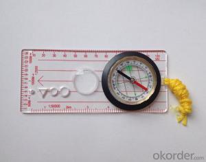
Map compass DC45-5B
- Ref Price:
-

- Loading Port:
- Tianjin
- Payment Terms:
- TT OR LC
- Min Order Qty:
- -
- Supply Capability:
- 5000 pc/month
OKorder Service Pledge
OKorder Financial Service
You Might Also Like


Product details
Model: DC45-5B
Name: Professional map compass, ruler compass
Product Origin: China
Supply Ability: 10,000 pcs/month
Minimum Order: 50 pcs
MOQ for OEM package: 500pcs
Product Size: 112*62*17 (mm)
Color: OEM
Features
1, professional usage: orientation, distance measuring, measuring slope, azimuth and pitching Angle measurement, drawing, a magnifying glass
2, high quality compass with neck rope, portable and rugged
3, ACRYLIC material, about 2mm thick
4, Damping Dial: to keep the stability of the pointer, more suitable for outdoor
environment.
5, Accuracy: accurate and clear, there were 360 degrees azimuth Angle, outer ring is 64-00 system, Liquid filled in the compass for reliable readings.
6, Magnifier function
- Q: Is it accurate to measure highway mileage with GPS handheld
- Can only say that the handheld GPS measurement of highway mileage can be a reference, if you want to measure the accuracy or sub meter level or professional measuring tools better
- Q: Handheld GPS locator measuring accuracy is about how many meters?
- The higher the accuracy, the higher the price. You can consult the Haida official website mobile MGIS mall
- Q: Can a handheld navigator connect a cell phone? Thank you
- Open the phone hotspot WiFi, handheld navigator connected to this wifi.
- Q: Hand held GPS coordinate conversion method
- Three parameter test DX, DY, DZ, DA, DF after the conversion parameters of the five, must be prompted to enter the handheld GPS, while the input area of the central meridian longitude. E on behalf of the east longitude, projection ratio of 1, the deviation of things to the north and south of the deviation of 0, and set the unit for M. Enter these parameters, should be taken to the field test, check whether these five parameters are correct. The method is selected, vision, GPS receiving signal strength of the feature points in the field (such as linear object intersections, independent features, etc.) is the best stone control points were measured and compared with theory and find out the coordinates of these points. If the results of the comparison exceed the nominal accuracy of the instrument, the conversion parameters or the problems that should be found should be recalculated.
- Q: Jia Ming etre20 handheld GPS good
- The new generation of the eTrex series is the first generation of user level receivers that can track both GPS and GLONASS satellites. GLONASS global navigation satellite system developed by Russian Federation, fully put into use. When using the GLONASS satellite, the average time for the receiver to lock the target is about 20% faster than GPS. And, when using both GPS and GLONASS, the receiver has the ability to lock more than 24 satellites as compared to GPS alone.
- Q: Handheld GPS and mobile phone GPS what is the difference?
- The same: GPS main chip may be the same; can complete the GPS positioning;
- Q: What do you need to test for GPS?
- 5.DGPS you know, differential GPS (DGPS) positioning accuracy is very high, some GPS equipment providers set up a DGPS transmitter in some areas, free of charge to its customers, if customers are buying GPS receivers with DGPS function. The DGPS transmitter is a fixed GPS receiver (in a 100km ~ 200km exploration scene in the radius setting) receive satellite signals, it knows exactly what is the exact time of transmitting satellite signal to the theory, and then compare it with the actual delivery time, then calculate the "difference", influence this is very close to the atmospheric refraction, it will send out the difference, usually with FM (FM) radio data transmission using subcarrier modulation signal in the baseband receiver, GPS and DGPS function can receive and use it more accurate positioning.
- Q: The navigation module it is "selph" three generation? Another one I mainly use it to measure the land area, easy to use, the error is not big?I want to buy Magellan 500 do not know whether it is good to use
- Professional handheld GPS only Magellan and set SIBAO
- Q: Handheld GPS purchaseHandheld GPS navigator!Is mainly used for tourism, I said is not a mobile phone, is a more professional handheld GPS navigator for travel outside! Handheld GPS navigator can voice navigation?
- The more high-end is good, clever and wheat zalun, many outdoor enthusiasts are used to this, hiking, cycling and other applications are relatively wide, is an American brand, Mazelen returned to the U.S. Army GPS, and as Ma Ying-Jeou ring when riding on the handlebar also puts a high out of this two 60CSX. the brand in the nature, the price is more expensive, in more than 2000, but the best is to the store to buy.
- Q: What is the difference between professional navigation and professional GPS navigator
- 3 map software is accurate, you can identify the road on the viaduct, and you can tip up and down viaduct."This should be no problem currently on the market of the navigation software is mainly three: Skywalker, Kai Lide, cityonmap. Three navigation software has its own advantages and disadvantages. I personally feel that the person with Skywalker more, some car navigation systems (non open operating system) OEM software with Kay more than cityonmap map Skywalker is better but the interface is not good.4 mobile phone PDA load or other independent GPS devices can be.
Send your message to us
Map compass DC45-5B
- Ref Price:
-
- Loading Port:
- Tianjin
- Payment Terms:
- TT OR LC
- Min Order Qty:
- -
- Supply Capability:
- 5000 pc/month
OKorder Service Pledge
OKorder Financial Service
Similar products


Hot products


Hot Searches

