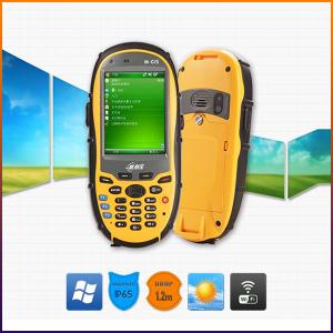


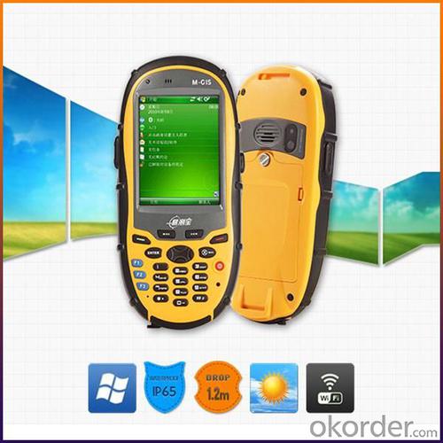

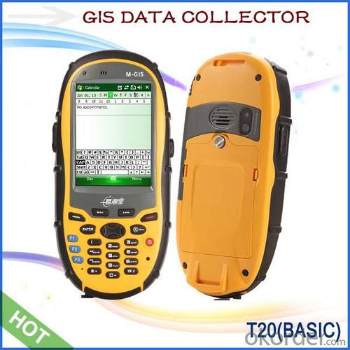
GIS Data Collector
- Ref Price:
-

- Loading Port:
- China Main Port
- Payment Terms:
- TT or LC
- Min Order Qty:
- 10 set
- Supply Capability:
- 200 Sets Per Day set/month
OKorder Service Pledge
OKorder Financial Service
You Might Also Like


Key Features:
1. Fast GPS receiver with 50 channels, high sensitive and anti-interference antenna.
2. Optional mobile operation system: Windows Mobile6.1 or Mobile6.5 or Android 2.3, high compatibility.
3. 3.5G communication mode, Bluetooth, WIFI, multi-mode data transmission for whole T20 series, camera and microphone for multimedia data collection, RFID provides convenient conditions for asset management users.
4. 5 megapixel camera, automatic focus, adding geographic coordinate function for photos.
5. Double input modes: Touch screen and keyboard.
6. SDK support.
7. 3-proof design IP65, compact, portable and convenient.
Product Models:


Technology Specs:
GNSS performance | Channel | 50 channe,l L1 |
Antenna | High sensitive, anti-interference antenna | |
Real Time Accuracy | 3~5M | |
DGPS(RMS) | 1~3M(SBAS),<1m(RTCM Input) | |
System | Operation System | Microsoft Windows Mobile6.1 or Mobile6.5, or Android 2.3 |
CPU | 806MHz | |
Memory | 256MB RAM | |
Output | Max. 4Hz output | |
Equipment Character | Camera | 5 megapixel camera with autofocus, Max. resolution 2592*1944 pixel, supports photos and position coordinate collection. |
Keyboard | 10 digital keys, supports figure, English input, 9 system function keys, provides SDK, supports user-defined, 3 quick start keys, visible in night. | |
Microphone | Supports voice recording | |
Speaker | Built-in speaker | |
TF Memory Card | Standard 2G, Supports Up To 32G | |
Communication Function | Cellular Voice&Data(Optional) | HSDPA,3.5G/WCDMA/GPRS |
Bluetooth | 2.1+EDR | |
Wi-Fi | Supports 802.11b/g/n, wireless LAN | |
RFID (optional) | 13.56MHz RFID | |
USB port | MiniUSB2.0 | |
Series port | Supports Protocol RS232 | |
Physical | Display | 3.2”(diagonal ) touch screen |
Display Effect | 320*240 pixel, 260,000 colors | |
Waterproof | IP65 | |
Drop | Naturally 1.2 m drop over concrete | |
Working Temperature | -20°C ~ +60°C | |
Storage Temperature | -30°C ~ +70°C | |
Dimension | 165*78*28mm | |
Net Weight | 230g(including battery) | |
Packing | Packing Box Dimension | 205*135*85mm |
Gross Weight | 701g | |
Power Supply | Battery | 3100mAH rechargeable and replaceable Li-ion battery, 10H working time |
Languages | Operation System languages |
Chinese(Simplified) Chinese(HongKong), English, Spanish, French, German, Dutch, Italian, Russian (It is discussable to change the language provided the quantity is large) |
Field Software Languages | Chinese, English,Portuguese(Brazil),Spanish,Romanian, Swedish, Turkish,Polish, Arabic, Estonian, Finnish, French, German, Greek, Hebrew, Hungarian, Japanese, Korean, Latvian, Lithuanian, Norwegian, Pashto, Czech, Danish, Dutch |
Remarks:
1. Specifications subject to change without notice.
2. Accuracy and reliability depend on the quality of GPS signal and working environment.
3. Battery life time and charge cycles will vary with conditions and environment of use.
4. Software may vary depending on configuration.
5. Weight varies from configurations and optional accessories.
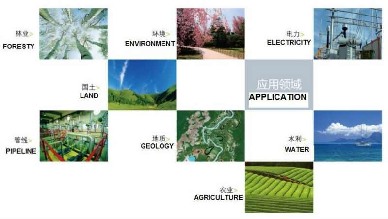
Application:
Utilities: Asset management, rapid response.
Local government: Asset management, issue reporting, emergency mangement.
Environmental management:Data collection.
Packing:

Delivery:

- Q: I would like to ask the GPS handset and GPS receiver (Surveying and mapping qualification application needs) is there a difference? If yes, what is the difference?
- GPS handheld GPS operating manual, GPS receiver is to receive satellite signals, GPS consists of two components.
- Q: GPS Mu meter which brand is good, handheld high-precision land area measuring instrument
- A German born mu can also recommend a good precision measuring instrument.
- Q: Can you buy a good handheld GPS in China? FiveTrouble master recommended several professional handheld GPS brand, in addition to handheld GPS can speed it? Thank you!!
- If it is used, there is no difference.
- Q: What is the difference between the phone's GPS and professional handheld GPS features and differences?
- With more professional and more accurate positioning but are generally used dry batteries or rechargeable batteries not built-in rechargeable battery that is because handheld GPS users are mostly investigation or walk tourists convenient in use and emphasizes there is screen are generally of low power consumption for general color screen can only convey longitude and altitude mobile phone GPS is just a subsidiary function loading car navigation map
- Q: I bought the way k20s, this handheld GPS how
- Ordinary hand-held GPS is 3-5 meter accuracy, high accuracy can be achieved unless buy submeter ordinary user, if you can.
- Q: I am a handheld GPS precision is low, how to use to be able to improve certain accuracy.
- If the carrier phase measurement function is not available, you have the maximum accuracy of GPS accuracy of 1-10This can only improve the observation environment using SBAS and other ways to improve the accuracy
- Q: How to hand GPS eTrex H data to the computer
- "Shaanxi skmax navigation information Limited" GARMIN proxy (GARMIN official website can be found), contact (Xiao Hou) the hope can help to you, if you do not understand what we see on the Internet, may at any time, contact us!
- Q: I just bought a handheld GPS Magellan No. 1, showing the latitude and longitude coordinates, I want to set the geodetic coordinates of latitude and longitude, do not know where to set, I would like to ask you, how to set, there is a better picture shows the best, thank you so much.Magellan GPS 210 is not 2000 shy
- 2 map reference setting: [[map] - unit "benchmark is set to User, and input the DX, DY, DZ, DA, DF parameters, usually DX, DY, DZ vary from region to region, so need to know the high level control points to solve, solving methods are as follows:The handheld GPS is placed in the control point field buried pile, were measured, and then hand coordinate coordinates and the known control points of the GPS measurements obtained for the poor, can be obtained by local coordinates and elevation deviation value: DX, DY, DZ.
- Q: How the German born handheld GPS Mu meter, I want to buy?
- Ergonomic design of lightweight and flexible dynamic appearance collocation black shell, the rear panel detector specially equipped with lights, emergency lights, more appropriate and practical, are small and easy to carry, dustproof, seismic, high temperature resistant, high capacity lithium battery long time power supply, full compliance with the harsh working environment.
- Q: Handheld GPS, the measurement of arable land, fixed point and circle test, which is more accurate,
- If the measurement point is only the case, the dynamic GPS is now the general error can be guaranteed within 3cm, the total station can be guaranteed to the millimeter.
1. Manufacturer Overview
| Location | Guangzhou, China |
| Year Established | 1999 |
| Annual Output Value | US$ 45.75 Million |
| Main Markets | Korea; Iran; Indonesia; Philippine; Poland; Italy; Brazil; South Africa; Russia |
| Company Certifications | FCC; CE |
2. Manufacturer Certificates
| a) Certification Name | |
| Range | |
| Reference | |
| Validity Period |
3. Manufacturer Capability
| a) Trade Capacity | |
| Nearest Port | Shenzhen; Guangzhou |
| Export Percentage | 8% |
| No.of Employees in Trade Department | 900 People |
| Language Spoken: | English; Chinese; Spanish; Arabic |
| b) Factory Information | |
| Factory Size: | Occupy 3000 square meters |
| No. of Production Lines | Above 5 |
| Contract Manufacturing | OEM Service Offered; Design Service Offered |
| Product Price Range | High; Average |
Send your message to us
GIS Data Collector
- Ref Price:
-
- Loading Port:
- China Main Port
- Payment Terms:
- TT or LC
- Min Order Qty:
- 10 set
- Supply Capability:
- 200 Sets Per Day set/month
OKorder Service Pledge
OKorder Financial Service
Similar products

Hot products


Hot Searches
Related keywords

