• Industrial Windows PDA MT06 System 1
Industrial Windows PDA MT06

Industrial Windows PDA MT06

Ref Price:
get latest price
Loading Port:
China Main Port
Payment Terms:
TT OR LC
Min Order Qty:
-
Supply Capability:
-

Add to My Favorites

Follow us:


OKorder Service Pledge

Quality Product, Order Online Tracking, Timely Delivery

OKorder Financial Service

Credit Rating, Credit Services, Credit Purchasing
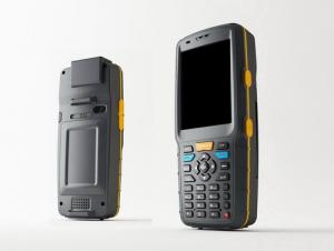
MT06 Series is a rugged PDA with high performance application processor, GPRS/EDGE, and RFID readers. With its Bluetooth and Wi-Fi, it could be connected to various devices and networks. It has been used in many application fields, such as mobile data collection, inventory management, membership management, etickets, access control and so on. This is a low cost model compared to MT02 Series, for it removes GPS, 3.2inch Transflective LCD, 3.0Mege Auto Focus Camera, and could be used as just a rugged PDA.
Features:
􀂄 IP54
􀂄 Window Mobile 6.1 and 6.5, WinCE 6.0
􀂄 Bluetooth EDR2.1 and Wi-Fi 802.11b/g
􀂄 RFID 13.56MHz 14443A/B read and write
􀂄 Battery 3000mAh (5000 times 1D barcode scanning, continuous)
Hardware
CPUMarvell PXA310(624MHz)/can update to 806MHz
RF BandGSM Quad-band 850/900/1800/1900MHz, GPRS, EDGE
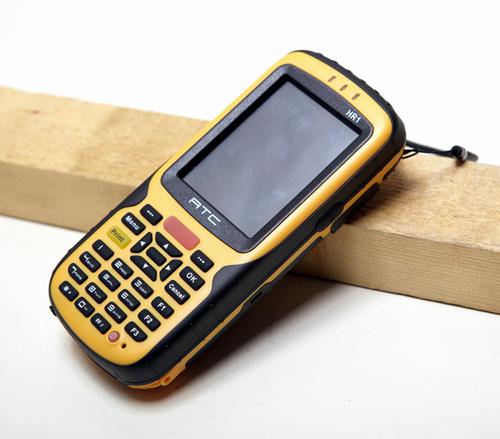
Display 2.8inch TFT LCD display  (320 x 240) 65k color/touch panel
Form FactorBar type classical Pocket PC,Industrial appearance
MemoryFlash ROM256MB
RAM128MB DDR
Extend SlotMicro SD 16G (SDHC)
GPS SolutionUblox The 5th Generation
Wire TransmissionUSB 2.0 Full Speed, charging/sync
BluetoothBluetooth SIG version 2.0 compliant; Supported profiles: headset, hands-free, object push, serial port, dial-up network
WiFiWiFi (802.11 b/g)
RFID(OPTION)read and write (13.56MHz ISO 14443A/B)
Laser scannerOPTION
External InterfaceRS232;SPI;print
Protection classIP54
Drop resistance level 1.8m
AudioHandfreeYes
StereoBlueTooth earphoneYes
Ringtonesupport 64-chord MIDI, MP3, WMA, WAV
Playbacksupport MIDI, MP3, WMA, WAV, AMR
Speakersupport handfree
Network Ledred/green/yellow
KeypadFront Number key, Function key
SideVolume up, Volume down,camera
InterfaceMini-USB connectorUSB2.0 connection and power charging
SIM card slotYes
Audio JackNO
BatteryTyperechargeable Li-ion battery 3000mAh
Standby Time500hours
Calls TimeUp to 6hours
Charging Time4 hours
Physical CharacteristicsDimension149*72*28mm
WeightTBC
Key Software
Operating SystemWindows Mobile 6.1 professional/wince 6/ WINCE6.0
Office MobileExcel MobileYes
Word MobileYes
Powerpoint MobileYes
OutlookYes
Personal AssistantCalculatorYes
CalendarYes
AlarmYes
Windows Media PlayerYes
Internet ExplorerYes
TaskYes
NoteYes
PC ToolsActiveSync4.5
MessageSMSSupport concatenated SMS; 10 built in SMS templates;support multi-recipients
MMSSupport JPEG/GIF89a/WBMP/GIF87/3GPP
Support USSD phase 2Yes
Pocket MSNYes
KVMJAVA MIDP 2.0
Default languageEnglish
Package Contents
Standard Packaging:   Main Unit*1pc,  Charger*1pc,  USB Cable*1pc, battery*1pc
Q:My friend is in use, the difference is not big, professional handset (smart or Magellan bulky, but 3 case), but the price is expensive, but can not call and map is very rotten, endurance of 10 hours (dry battery) the mobile phone also has all the time. Know friends say, I mainly in the suburbs! Thanks
Professional GPS is mainly used for acquisition, is not used for navigation; of course, some professional GPS can install third party software, the accuracy is higher than the phone, this is positive;Mobile navigation is only used for navigation, navigation, path analysis and navigation functions, not the acquisition of maps of the instrument.
Q:Saying that we have a project in front of it is to do so, it is surprising that there are wood
Hello friends, so, do 1:2000 topographic mapping with a handheld GPS is obviously not reality, after all, the handheld GPS precision is, however, now we are in the handheld equipment is no GPS, in fact, in the absence of the base station is a handheld GPS, receiving SBAS difference can reach sub meter level, but if a base station or receive CROS network differential signal will be RTK mobile station,
Q:Mountaineering to buy a professional GPS or Mountaineering Watch
Can be downloaded in general maps, satellite maps, and even contour maps, which features far more than handheld GPS or mountain climbing watches, you can better meet the needs of mountaineering.
Q:Is it accurate to measure highway mileage with GPS handheld
Can only say that the handheld GPS measurement of highway mileage can be a reference, if you want to measure the accuracy or sub meter level or professional measuring tools better
Q:Handheld GPS purchaseHandheld GPS navigator!Is mainly used for tourism, I said is not a mobile phone, is a more professional handheld GPS navigator for travel outside! Handheld GPS navigator can voice navigation?
Many outdoor enthusiasts are used to this, hiking, cycling and other applications are relatively wide, is an American brand, Mr Zelen back to U.S. Army GPS, and as Ma Ying-Jeou ring when riding on the handlebars also put a good 60CSX. the two brands in the nature, the price is more expensive, are in more than 2000, but the best is to the store to buy. If only for tourism, generally hundreds of pieces of GPS will be enough, go to computer city to see, must be sold, or go to your city in the outdoor store to see.
Q:GPS handheld function to measure it?
It depends on what kind of GPS handset. Some machines have this feature.
Q:Handheld GPS positioning, can be directly uploaded to the computer, and the computer has a scalable map to mark the upload point. The above system, now there are 20Such as the title, I want to achieve the final function: through the manual to a point, with a hand-held GPS locator will be recorded in the specific latitude and longitude, and sent to the network in real time, for my computer to mark these points on the map. If you can directly enter the site of some of the information, directly to the above is the bestIf you have the above equipment, please indicate the scientific name, and the specific application industry.Thanks.
7 support for added map marking, distance measurement and area measurement, location name display.8 support Hawkeye display thumbnail map, screenshot function.9 support to add custom logo icon, the user can change icon.
Q:How to upgrade handheld navigator
Hello to the brand's official website to download the latest map copy to memory card on the lineI wish you a pleasant car!
Q:Professional handheld GPS GARMIN (DR) how to use
Look at the functional machine should use the instructions
Q:I am ready to go to the field to go to college, but I do not know how to buy a handheld GPS, I hope you recommend. The most important thing is easy to carry.
Oh, if you go abroad to go to college, buy a map you can, no need to buy, if you want to buy, you have to look at what price, what configuration, entry-level like upstairs said, a few hundred dollars can buy one, but is relatively old models. No maps. If you want to have a map to your point, there are Yiliangqianliangsanqian. Recommended Garmin 60csx, Magellan explorer, Hua Cai Lu N400 can be.

1. Manufacturer Overview

Location
Year Established
Annual Output Value
Main Markets
Company Certifications

2. Manufacturer Certificates

a) Certification Name  
Range  
Reference  
Validity Period  

3. Manufacturer Capability

a)Trade Capacity  
Nearest Port
Export Percentage
No.of Employees in Trade Department
Language Spoken:
b)Factory Information  
Factory Size:
No. of Production Lines
Contract Manufacturing
Product Price Range

Send your message to us

This is not what you are looking for? Post Buying Request

Similar products

New products

Hot products


Related keywords