
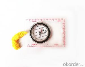


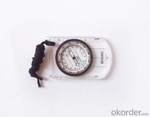
Professional Mapping Mini Compass with Scale
- Ref Price:
-

- Loading Port:
- Tianjin
- Payment Terms:
- TT OR LC
- Min Order Qty:
- 50 pc
- Supply Capability:
- 10000 pc/month
OKorder Service Pledge
OKorder Financial Service
You Might Also Like


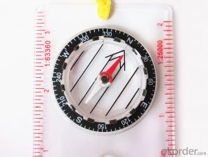
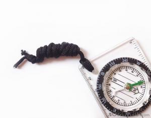
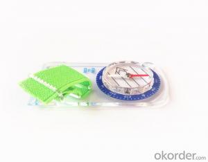
Structure of Mapping Compass Discription
Model: DC35-1A
Name: Professional map compass, ruler compass
Product Origin: China
Supply Ability: 10,000 pcs/month
Minimum Order: 50 pcs
MOQ for OEM package: 500pcs
Main Features of Mapping Compass
1, professional usage: orientation, distance measuring, measuring slope, azimuth and pitching Angle measurement, drawing, a magnifying glass
2, high quality compass with neck rope, portable and rugged
3, ACRYLIC material, about 2mm thick
4, Damping Dial: to keep the stability of the pointer, more suitable for outdoor environment.
5, Accuracy: accurate and clear, there were 360 degrees azimuth Angle, outer ring is 64-00 system, Liquid filled in the compass for reliable readings.
6, Magnifier function
7,one meter neck rope,
8,Liquid filled in the compass for reliable readings,
9, magnifier function.
10,night vision map compass
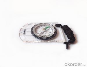
Mapping Compass Images


Map Scale Compass Specification:
Product Size: 86*60*10 (mm)
Color: OEM
FAQ of Map Scale Compass:
1,What is the warranty for this product?
3 months after receiving the device.
2,How long could we get the goods?
Within one week after payment, the product will be sent out.
3,Do you have service centers abroad?
No.The service centers are in China at present.
- Q: Handheld GPS positioning, can be directly uploaded to the computer, and the computer has a scalable map to mark the upload point. The above system, now there are 20Such as the title, I want to achieve the final function: through the manual to a point, with a hand-held GPS locator will be recorded in the specific latitude and longitude, and sent to the network in real time, for my computer to mark these points on the map. If you can directly enter the site of some of the information, directly to the above is the bestIf you have the above equipment, please indicate the scientific name, and the specific application industry.Thanks.
- 10 classification layer management, you can hide / show layer.11 support batch import export data.12 support for drawing straight lines, curves and any line segments, can change the color and width.
- Q: I am ready to go to the field to go to college, but I do not know how to buy a handheld GPS, I hope you recommend. The most important thing is easy to carry.
- At present, the formal channels genuine licensed not so cheap, some refurbished machines may have. The cheapest machines now have about 900-1000!
- Q: I am a handheld GPS precision is low, how to use to be able to improve certain accuracy.
- Look at the maximum accuracy of GPSIf the difference accuracy can reach 1cm you can connect CORS single base station and other network RTK way to achieve the corresponding accuracy
- Q: Hand held GPS coordinate conversion method
- Three parameter test DX, DY, DZ, DA, DF after the conversion parameters of the five, must be prompted to enter the handheld GPS, while the input area of the central meridian longitude. E on behalf of the east longitude, projection ratio of 1, the deviation of things to the north and south of the deviation of 0, and set the unit for M. Enter these parameters, should be taken to the field test, check whether these five parameters are correct. The method is selected, vision, GPS receiving signal strength of the feature points in the field (such as linear object intersections, independent features, etc.) is the best stone control points were measured and compared with theory and find out the coordinates of these points. If the results of the comparison exceed the nominal accuracy of the instrument, the conversion parameters or the problems that should be found should be recalculated.
- Q: Jia Ming etre20 handheld GPS good
- The new generation of the eTrex series is the first generation of user level receivers that can track both GPS and GLONASS satellites. GLONASS global navigation satellite system developed by Russian Federation, fully put into use. When using the GLONASS satellite, the average time for the receiver to lock the target is about 20% faster than GPS. And, when using both GPS and GLONASS, the receiver has the ability to lock more than 24 satellites as compared to GPS alone.
- Q: I am a handheld GPS precision is low, how to use to be able to improve certain accuracy
- Look at the maximum accuracy of GPSIf the difference accuracy can reach 1cm you can connect CORS single base station and other network RTK way to achieve the corresponding accuracy
- Q: Saying that we have a project in front of it is to do so, it is surprising that there are wood
- It is really unexpected, basically not, the accuracy is not enough!
- Q: How to hand GPS eTrex H data to the computer
- Computer installed on the MapSource software, connect the data cable, upload waypoints and tracks can be!
- Q: Magellan GPS handheld why so many people choose not to say that the map is not good
- Outdoor use three times a year also on the trip, but also want to use both sides can be used to the best, so these are the best of the two Ming and Magellan did not know that the election of the good, but I am willing to build businesses with the best Ming of the 450.Chasing the answerIf only in the city with less than 610510 can be upgraded Magellan navigation, 610 more than and 510 three axis electronic compass if you don't like the original forest does not receive any signal where there is no whatTake a look at yourself
- Q: What is the difference between professional navigation and professional GPS navigator
- 3 map software is accurate, you can identify the road on the viaduct, and you can tip up and down viaduct."This should be no problem currently on the market of the navigation software is mainly three: Skywalker, Kai Lide, cityonmap. Three navigation software has its own advantages and disadvantages. I personally feel that the person with Skywalker more, some car navigation systems (non open operating system) OEM software with Kay more than cityonmap map Skywalker is better but the interface is not good.4 mobile phone PDA load or other independent GPS devices can be.
Send your message to us
Professional Mapping Mini Compass with Scale
- Ref Price:
-
- Loading Port:
- Tianjin
- Payment Terms:
- TT OR LC
- Min Order Qty:
- 50 pc
- Supply Capability:
- 10000 pc/month
OKorder Service Pledge
OKorder Financial Service
Similar products


Hot products


Hot Searches
Related keywords

