
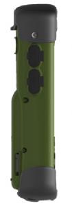
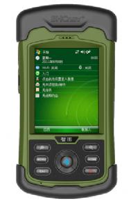
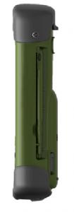
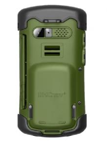


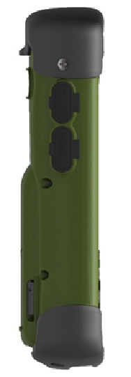
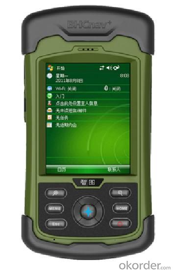
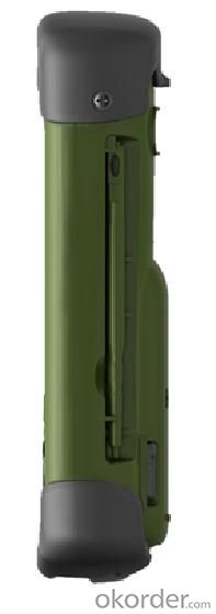
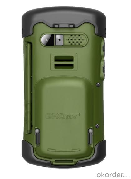
M50 GIS DATA COLLECTOR
- Ref Price:
-

- Loading Port:
- China Main Port
- Payment Terms:
- TT or LC
- Min Order Qty:
- 10 unit
- Supply Capability:
- 1000 Sets per Month unit/month
OKorder Service Pledge
OKorder Financial Service
You Might Also Like


M50 GIS DATA COLLECTOR
Premium, rugged, handheld GPS with camera, microphone, and speaker to record all your actions and navigate the outdoors
+3 mega-pixel Camera
+Built-in Barometric altimeter, E-compass, etc.
+3.5 Inch Touch Screen
+Integrated high-sensitivity multidirectional GPS antenna
Specification:


Remarks:
1. Specifications subject to change without notice.
2. Accuracy and reliability depend on the quality of GPS signal and working environment.
3. Battery life time and charge cycles will vary with conditions and environment of use.
4. Software may vary depending on configuration.
5. Weight varies from configurations and optional accessories.
Certificates:

Standard Packing:
GISA device(M50 GIS DATA Collector)
•Li-ion battery
•AC power adapter
•USB cable
•Handheld strap
•Stylus pen with string
•Screen protector
•Quick guide
•Inspection card
•CD
•4G micro SD card
Application:

Utilities: Underground asset mapping and inspection, water network modelling, as-built mapping of lines/cable installations, and incident/outage reporting.
Local government: High-density urban asset mapping, underground asset relocation, municipal asset inventory and inspection.
Environmental management: Weed management, water debris management, pollution mapping, environmental incident mapping, sample gathering, agricultural subsidy determination.
Warranty Period:
12 months after the delivery time from our factory for our M50 GIS Data Collector.
After Sale Service:
After Sale, We provide free technical support via e-mail, skype chatting, telephone or video if necessary for our M50 GIS data collector. Or you could also dispatch your engineers to our company, we can offer free training face to face. You should please bear the air tickets and all costs when staying in China. We offer additional accessories if you need. But the additional accessories will be charged.
Notices:
1. All our field software free of charge.
2. We have most of our products in stock and samples are available.
3. MOQ is one set.
4. For large quantity, we accept OEM production(printing customer's logo on the products)
Delivery :

- Q: Handheld GPS how to achieve decimeter
- Hello A GPS is not up to the requirements of the class, if no one can buy that expensive submeter GPS, currently on the market with the best precision is GPS, is Derek GARMIN this year a new eTrex 10, 20 and 30, the three can be reached within 3 meters accuracy, you can look at
- Q: GPS Mu meter which brand is good, handheld high-precision land area measuring instrument
- A German born mu can also recommend a good precision measuring instrument.
- Q: How to set the handheld GPS related parameters and coordinate conversion parameters throughout the country
- Two. To coordinate the coordinate data of the control points obtained provide technical support unit of Beijing Unistrong companies around the branch responsible person to calculate the coordinate transformation parameters conversion parameters, or to obtain their own conversion conversion software. After the conversion parameters are calculated by the prompt input handheld GPS. Only after such a setup, after all the soil in the region when the coordinates of the GPS read out the coordinates of the point for the Beijing 54 coordinates.
- Q: What is the difference between professional GPS handsets and mobile navigation?
- First of all, if used outdoors, then fell, and so on are likely to water, and this thing is also very expensive, so the opportunity to have a high professional anti shock waterproof performance. You can see the Challenger I tour the next 600, three well plates.
- Q: Mountaineering to buy a professional GPS or Mountaineering Watch
- There is no need to buy too many devices. Now the phone is an essential tool, the phone has GPS,
- Q: How to use the handheld GPS whole watershed investigation
- The critical value is an object from a physical state to another physical state, a physical quantity to meet the conditions, which is equivalent to the stagnation point in Mathematics
- Q: What do you need to test for GPS?
- 5.DGPS you know, differential GPS (DGPS) positioning accuracy is very high, some GPS equipment providers set up a DGPS transmitter in some areas, free of charge to its customers, if customers are buying GPS receivers with DGPS function. The DGPS transmitter is a fixed GPS receiver (in a 100km ~ 200km exploration scene in the radius setting) receive satellite signals, it knows exactly what is the exact time of transmitting satellite signal to the theory, and then compare it with the actual delivery time, then calculate the "difference", influence this is very close to the atmospheric refraction, it will send out the difference, usually with FM (FM) radio data transmission using subcarrier modulation signal in the baseband receiver, GPS and DGPS function can receive and use it more accurate positioning.
- Q: In addition to the parameters, that is the problem of the machine, what method can reduce the error of these two machines to a minimum. Because, at the same time to find a coordinate. The gap is too big.
- GPS was in error with 10 meters, with the star search results, related to the environment, if the precision is high, as long as the use of handheld GPS submeter or handheld RTK
- Q: Saying that we have a project in front of it is to do so, it is surprising that there are wood
- It is really unexpected, basically not, the accuracy is not enough!
- Q: Magellan GPS handheld why so many people choose not to say that the map is not good
- Select the right access to GPS oh it has a contact information users
1. Manufacturer Overview
| Location | Beijing, China |
| Year Established | 2004 |
| Annual Output Value | Below US$1 Million |
| Main Markets | Mid East; Northern Europ;Africa; Southeast Asia |
| Company Certifications | RoHS;CE;FCC;CCC;ISO |
2. Manufacturer Certificates
| a) Certification Name | |
| Range | |
| Reference | |
| Validity Period |
3. Manufacturer Capability
| a) Trade Capacity | |
| Nearest Port | Tianjin; Qingdao |
| Export Percentage | 1% - 10% |
| No.of Employees in Trade Department | 500-999People |
| Language Spoken: | English; Chinese |
| b) Factory Information | |
| Factory Size: | Above 50,000 square meters |
| No. of Production Lines | Above 8 |
| Contract Manufacturing | OEM Service Offered;Design Service Offered |
| Product Price Range | High;Average |
Send your message to us
M50 GIS DATA COLLECTOR
- Ref Price:
-
- Loading Port:
- China Main Port
- Payment Terms:
- TT or LC
- Min Order Qty:
- 10 unit
- Supply Capability:
- 1000 Sets per Month unit/month
OKorder Service Pledge
OKorder Financial Service
Similar products


Hot products


Hot Searches
Related keywords

