


PDA GIS Data Collector
- Ref Price:
-

- Loading Port:
- China Main Port
- Payment Terms:
- TT or LC
- Min Order Qty:
- 10 set
- Supply Capability:
- 200 Sets Per Day set/month
OKorder Service Pledge
OKorder Financial Service
You Might Also Like


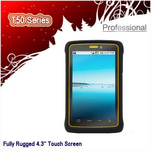
Specifications:
Handheld PDA
1. Android 4.3'' Screen Size
2. 800MHz, 512M RAM
3. Dual Camera: 5MP+2MP
4. IP66, MIL-STD-810F
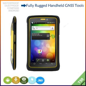
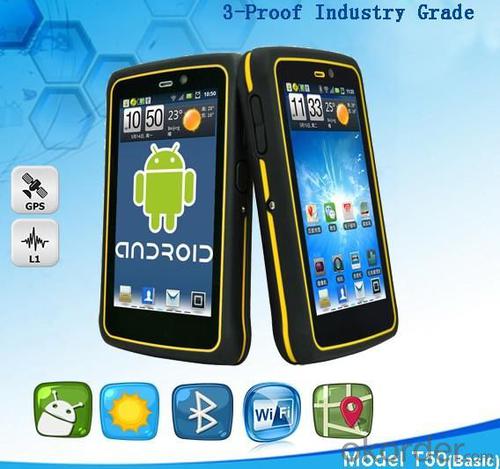
Android 2.3 Touch Screen Military Standard 3-proof Handheld PDA, GIS Data Collector, Gps Gnss Dgps Navigation
Key features:
1. Sunlight-readable 4.3’’(diagonal ) colorful screen, resolution 800*480 pixel.
2. Integrated 3G, WCDMA communication, high data transmission, supports voice calls.
3. Android 2.3 or 4.1 operating system, extensive application.
4. 3-proof IP66, accord with Military Standard MIL-STD-810F.
5. Dual cameras,5 megapixel main camera, supports photo and video, 2 megapixel secondary camera on front-facing.
6. Rechargeable and replaceable 2400AH Li-ion battery.
7. T50 series have a license for XTPRO professional software.
T50 Series Product Options:


Technology Specs:
System | Operating system | Android 2.3 or 4.1 |
Processor | 800MHz | |
Memory | 512M SDRAM 512M NAND flash | |
Positioning accuracy | Accuracy | 3~5m |
Difference | Supports WAAS,EGNOS,MSAS | |
Real-time difference | 1~3m | |
Equipment character | Compass | Yes |
Barometer | Yes | |
Display | 4.3’’(diagonal ) capacitive touch screen, 350nit, resolution 800*480 pixel | |
Camera | Dual cameras, 5 megapixel main camera and 2 megapixel secondary camera on front-facing. | |
Bluetooth | 2.1+EDR | |
Record | Yes | |
Speaker | Yes | |
Memory expansion | TF, supports 32G | |
Optical sensor | Yes | |
Range sensor | Yes | |
Communication function | Communication mode | WCDMA 3G GPRS |
WIFI | 802.11b/g/n | |
USB | USB2.0 | |
Physical | Military standard | MIL-STD-810F |
Waterproof | IP66 | |
Drop | Naturally 1.5m drop over concrete | |
Tumbling | 1,000 times in 0.5meter height | |
Relative humidity | 100% non-condensing | |
Working temperature | -20°C ~ +60°C | |
Storage temperature | -40°C ~ +70°C | |
Dimension | 132*82*21mm | |
Net weight | 230g(including battery) | |
Packing | Packing box dimension | 185*135*73mm |
Gross weight | 615g | |
Power supply | Battery | 2400mAH rechargeable and replaceable Li-ion battery |
Languages | Operation system languages: All languages Android 2.3 supports. | |
Remarks:
1. Specifications subject to change without notice.
2. Accuracy and reliability depend on the quality of GPS signal and working environment.
3. Battery life time and charge cycles will vary with conditions and environment of use.
4. Software may vary depending on configuration.
5. Weight varies from configurations and optional accessories.
Application:
Utilities: Asset management for Water, wastewater, gas, and electric.
Local government: Road and road asset management, public works installations, city-wide GIS data collection projects, scheduled asset inspections for compliance and metering, parks and urban forest maintenance and management.
Environmental management: Forest and park service management, fisheries management, general environmental management.
Standard Packing:

Delivery:

- Q: Highway measurement with GPS I do not know which of the base station settings and mobile station settings I are very vague, to the instrument to build a coordinate system how to build the relevant issues to me
- Defects of conventional measurement methods:1, the specification of the length of the attached wire, the length of the wire and the length of the wire between the nodes have strict requirements, generally for high grade roads are required to meet the requirements of the first line. In this way, the length of the wire shall not be more than 10 km, or the length of the wire shall not exceed the length of the wire attached to the attachment of the wire length of 0.7 times. This requirement is generally difficult to achieve in the actual work, often appear super standardized operations.2, to collect the starting point for the general route of measurement and control is difficult to ensure the same measurement system, the measurement and measurement, often in the city of control points mixed together, the compatibility between systems, if the starting point is not compatible, is bound to affect the quality of measurement.3, serious damage to the national site, the impact of measurement operations. Due to the country's basic control points, mostly completed in 50s and 60s, after more than 30 years, some point due to the needs of economic construction is destroyed, and some people because of the lack of knowledge of human destruction. Route survey work in these areas, often in the 50 km above all can not find the wire control points. The quality of the route control survey is not guaranteed.4, ground visibility difficulties often affect the implementation of conventional measurement. The control points of the general route shall be located within 300 meters from the course. Due to visibility reasons, it is difficult to meet the conditions, even in a large range, and the dense shrub forest area, simply can not implement conventional control measure.
- Q: Can you buy a good handheld GPS in China? FiveTrouble master recommended several professional handheld GPS brand, in addition to handheld GPS can speed it? Thank you!!
- In fact, the main function is to use navigation as long as the navigation function can be used
- Q: Can a handheld navigator connect a cell phone? Thank you
- Now basically use the phoneEasy update and operation
- Q: Hand held GPS coordinate conversion method
- By the 84 coordinates to Beijing 54 Coordinate. A collection of application area of high grade control data in GPS receiver applied earth area (such as a county) find three (or more) uniform grade (accuracy better) or GPS "B" dot, point the best is around without interference of electromagnetic wave, vision, satellite signal. To the local surveying and mapping management department (such as: the local bureau of Surveying and mapping, surveying and Mapping Institute) Gauss plane coordinate copy these points of the Beijing 54 Coordinate System (x, y), the elevation of H and WGS-84 coordinates of the geodetic coordinates (B, L), the high H.
- Q: Mobile GPS can replace professional handheld GPS
- Ziphah measured Mu instrument, a key measurement area, the use of simple, SV-118, with high precision imported GPS module and antenna, accurate measurement, the block walk in a circle to measure the size and graphics trajectory, 550 yuan, USB charging, large capacity lithium battery, black and white screen to see the clear day for outdoor use.
- Q: I am a handheld GPS precision is low, how to use to be able to improve certain accuracy
- If the carrier phase measurement function is not available, you have the maximum accuracy of GPS accuracy of 1-10This can only improve the observation environment using SBAS and other ways to improve the accuracy
- Q: In addition to the parameters, that is the problem of the machine, what method can reduce the error of these two machines to a minimum. Because, at the same time to find a coordinate. The gap is too big.
- GPS was in error with 10 meters, with the star search results, related to the environment, if the precision is high, as long as the use of handheld GPS submeter or handheld RTK
- Q: Fuxin coordinates with the mapping of the seven parameters are what ah there is no professional knowledge to tell my brother I need to fill the gps... Thanks.
- Handheld GPS has not been used, you can find three known control points, try to solve.
- Q: Handheld GPS purchaseHandheld GPS navigator!Is mainly used for tourism, I said is not a mobile phone, is a more professional handheld GPS navigator for travel outside! Handheld GPS navigator can voice navigation?
- Many outdoor enthusiasts are used to this, hiking, cycling and other applications are relatively wide, is an American brand, Mr Zelen back to U.S. Army GPS, and as Ma Ying-Jeou ring when riding on the handlebars also put a good 60CSX. the two brands in the nature, the price is more expensive, are in more than 2000, but the best is to the store to buy. If only for tourism, generally hundreds of pieces of GPS will be enough, go to computer city to see, must be sold, or go to your city in the outdoor store to see.
- Q: How the German born handheld GPS Mu meter, I want to buy?
- Brian GPS handheld measuring instrument type 30A is a German born Mu launched a new professional Mu instrument, using high sensitivity GPS receiver chip, GPS super signal tracking capability, satellite positioning easily.
1. Manufacturer Overview
| Location | Guangzhou, China |
| Year Established | 1999 |
| Annual Output Value | US$ 45.75 Million |
| Main Markets | Korea; Iran; Indonesia; Philippine; Poland; Italy; Brazil; South Africa; Russia |
| Company Certifications | FCC; CE |
2. Manufacturer Certificates
| a) Certification Name | |
| Range | |
| Reference | |
| Validity Period |
3. Manufacturer Capability
| a) Trade Capacity | |
| Nearest Port | Shenzhen; Guangzhou |
| Export Percentage | 8% |
| No.of Employees in Trade Department | 900 People |
| Language Spoken: | English; Chinese; Spanish; Arabic |
| b) Factory Information | |
| Factory Size: | Occupy 3000 square meters |
| No. of Production Lines | Above 5 |
| Contract Manufacturing | OEM Service Offered; Design Service Offered |
| Product Price Range | High; Average |
Send your message to us
PDA GIS Data Collector
- Ref Price:
-
- Loading Port:
- China Main Port
- Payment Terms:
- TT or LC
- Min Order Qty:
- 10 set
- Supply Capability:
- 200 Sets Per Day set/month
OKorder Service Pledge
OKorder Financial Service
Similar products


Hot products


Hot Searches
Related keywords

