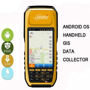
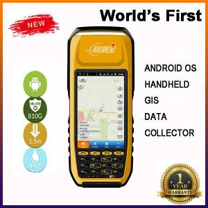

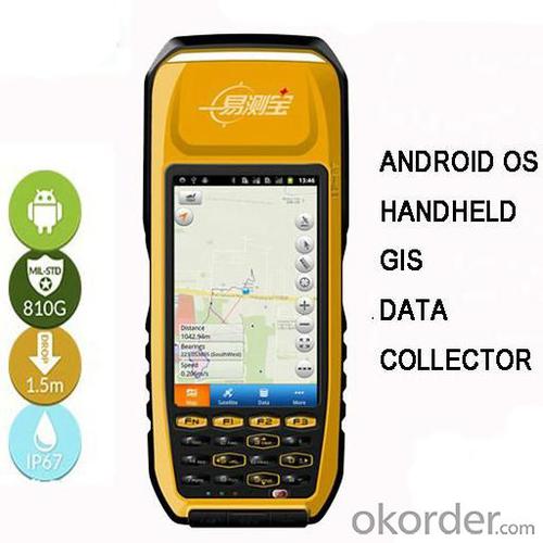


Android High Accuracy GIS Data Collector
- Ref Price:
-

- Loading Port:
- China Main Port
- Payment Terms:
- TT or LC
- Min Order Qty:
- 1 set
- Supply Capability:
- 1000 Sets per Month set/month
OKorder Service Pledge
OKorder Financial Service
You Might Also Like


Specifications:
Gps Android
1.Submeter accuracy, GPS, L1
2.4.3'',Android 2.3,800MHz, 512MB RAM
3.Bluetooth, WIFI,USB
Integrate SOS Of Powerful Features Gps Android, Supports SBAS(WASS/EGNOS/MSAA),With Laser Centering Device
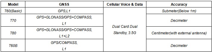
Product Models:
Key features:
1. Android 2.3 operation system, Fast data processing 800MB host processor,512MB RAM.
2. Big and sunlight-readable 4.3’’ touch screen, resolution 800*480 pixel.
3. Dual card and dual standby, 3.5G communication.
4. Professional multi-frequency (L1, L2), multi-satellite CNSS core (GPS/GLONASS/COMPASS), with built-in internal laser centering.
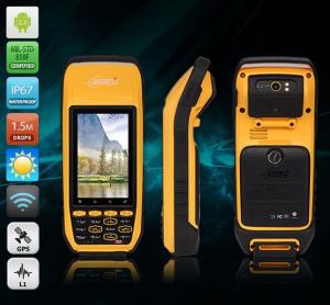
5. Rugged body, IP67 and Military Standard MIL-STD-810G by SGS Testing Report.
6. Convenient input: Full digital keyboard and a user-defined hard key.
Technology Specs:
GNSS Performance | Satellite Type | GPS/GLONASS/COMPASS | ||
Satellite Frequency Range | L1,L2 Dual-frequency | |||
Interstellar Difference | Supports SBAS(WASS/EGNOS/MSAS) | |||
Update Rate | 1Hz or More | |||
Accuracy | Real Time | 2.5m | ||
Static Process | 5mm+1ppm | |||
DGPS | Code | 60cm | ||
SBAS | <1m | |||
Real Time Centimeter Output (RTK, Model T80 Only) | Horizontal( External Antenna) | 1cm+1ppm | ||
Vertical( External Antenna) | 2cm+2ppm | |||
System | Operation System | Android2.3 | ||
Processor | 800MHz | |||
RAM | 512MB | |||
ROM | 512MB | |||
Equipment Character | Laser Centering | Built-in Laser Centering | ||
Camera | 5 Megapixel With Autofocus Camera, Supports 6 Times Digital Zoom,Dual LED Flashlights. | |||
Display | 4.3’’ (Diagonal) Screen, Resolution 800*480 Pixel | |||
Keyboard | Full Digital Keyboard And A User-Defined Hard Key | |||
Sensor | Electronic Compass, Barometric Altimeter And Gravity Sensors | |||
TF Memory Card Slot | Supports Up To 32GB | |||
Speaker | Built-In Speaker | |||
Communication Function | Communication Mode | 3.5G, Dual Card And Dual Standby | ||
Bluetooth | 2.1+EDR | |||
Wi-Fi | 802.11b/g/n | |||
USB | miniUSB2.0 | |||
Physical | Waterproof | IP67 | ||
Drop | Naturally 1.5m Drop Over Concrete | |||
Working Temperature | -20°C ~ +60°C | |||
Storage Temperature | -30°C ~ +70°C | |||
Dimension | 233*87*61mm | |||
Net Weight | 800g(Including Battery) | |||
Packing | Packing Box Dimension | 445*360*220mm | ||
Gross Weight | 3350g | |||
Power Supply | Battery | 7200mAH Li-ion battery, 12H working time | ||
Languages | Operation System Languages | All Languages Android 2.3 Supports | ||
Software Languages | Chinese(Simplified), English (It is discussable to change other languages provided order quantity is large) | |||
Remarks:
1. Specifications subject to change without notice.
2. Accuracy and reliability depend on the quality of GPS signal and working environment.
3. Battery life time and charge cycles will vary with conditions and environment of use.
4. Software may vary depending on configuration.
5. Weight varies from configurations and optional accessories.
Standard Packing:
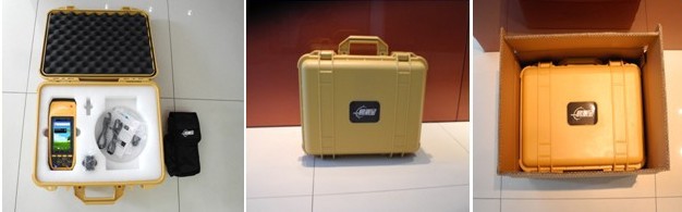
Remarks: For saving freight for the buyers, we also offer optional packing way with out the PC kit.
Application:
Utilities: Underground asset mapping and inspection, water network modelling, as-built mapping of lines/cable installations, and incident/outage reporting.
Local government: High-density urban asset mapping, underground asset relocation, municipal asset inventory and inspection.
Environmental management: Weed management, water debris management, pollution mapping, environmental incident mapping, sample gathering, agricultural subsidy determination.
Warranty Period:
12 months after the delivery time from our factory.
After Sale Service:
After Sale, We provide free technical support via e-mail, skype chatting, telephone or video if necessary. Or you could also dispatch your engineers to our company, we can offer free training face to face. You should please bear the air tickets and all costs when staying in China. We offer additional accessories if you need. But the additional accessories will be charged.
Others:
1. All our field software free of charge.
2. We have most of our products in stock and samples are available.
3. MOQ is one set.
4. For large quantity, we accept OEM production(printing customer's logo on the products)
Delivery:

- Q: I am ready to go to the field to go to college, but I do not know how to buy a handheld GPS, I hope you recommend. The most important thing is easy to carry.
- Younger brother, buy a smart phone, ranging from several hundred dollars to several thousand dollars, as long as the GPS module on the line, understand it?I'm not talking about it, as long as the smart phone with GPS module, you can use when GPS, can be used to drive, you can certainly use a walk. Even if there is no GPS die fast, with a cell phone signal can be positioned, but not too accurate. Hundreds of meters.In addition, you go to college, do not use smart phones, students are not afraid of jokes? Buy a Android system on the machine line. Cheap on a few hundred dollars.You say you take a hand-held machine, and then take a cell phone to go out, trouble is not trouble?
- Q: How to set the handheld GPS related parameters and coordinate conversion parameters throughout the country
- Collect the application area of high grade control data in GPS receiver applied earth area (such as a county) find three (or more) uniform grade (accuracy better) or GPS "B" network, the best point is around without interference of electromagnetic wave, vision, the satellite signal is strong. To the local surveying and mapping management department (such as: the local bureau of Surveying and mapping, surveying and Mapping Institute) Gauss plane coordinate copy these points of the Beijing 54 Coordinate System (x, y), the elevation of H and WGS-84 coordinates of the geodetic coordinates (B, L), the high H.
- Q: What is the difference between industrial GPS handset and mobile navigation
- 5, strong battery life, is a major feature of professional GPS, Garmin handset General of dry batteries can be used more than ten hours, while the mobile phone GPS on GPS also can use a few hours, if you open the GPS in general about 3 hours will be over.6, supporting different software. Professional GPS handheld opportunities related to the PC end of the data processing software, this software can achieve the acquisition of data processing, as well as the application of data collection. The phone GPS can only navigation, and navigation is only a small part of the GPS function.I simply say these, this is my personal summary of the difference, if you have what is not clear can exchange. Want to help you.
- Q: What is the difference between the phone's GPS and professional handheld GPS features and differences?
- If you travel enthusiasts so you still recommend buying the handheld bar dry batteries can be replaced immediately if it is built in deep mountains and forests where you go oh for charging software installation, you can go to the forum to see the relevant system is very simple and the most important point is that basically all the navigation software has cracked the free version allows you to use it here and I hope to help you
- Q: Want to buy handheld GPS in Hongkong, I would like to ask what brand is better, the specific model? Where to buy? How much is the price? In the mainland can be used? More questions, thank you!
- I doubt this question will be answered by the people of Hongkong?Handheld GPS do best is GARMIN, Taiwan and the mainland are agents. It's all the same.
- Q: Professional handheld GPS GARMIN (DR) how to use
- Look at the functional machine should use the instructions
- Q: Fuxin coordinates with the mapping of the seven parameters are what ah there is no professional knowledge to tell my brother I need to fill the gps... Thanks.
- XYZ offset, XYZ twist, 6, plus a scaling factor.Seven parameters have to be calculated, or from the local surveying and mapping departments to.
- Q: I just bought a handheld GPS Magellan No. 1, showing the latitude and longitude coordinates, I want to set the geodetic coordinates of latitude and longitude, do not know where to set, I would like to ask you, how to set, there is a better picture shows the best, thank you so much.Magellan GPS 210 is not 2000 shy
- 1 position: [format setting unit - "[] position display format is set to User UTM Grid, and enter the relevant parameters, such as the 3 degree or 6 degree with the area with the central meridian projection, the ratio was 1, that deviation is 500000m, north-south deviation is 0.2 map reference setting: [[map] - unit "benchmark is set to User, and input the DX, DY, DZ, DA, DF parameters, usually DX, DY, DZ vary from region to region, so need to know the high level control points to solve, solving methods are as follows:The handheld GPS is placed in the control point field buried pile, were measured, and then hand coordinate coordinates and the known control points of the GPS measurements obtained for the poor, can be obtained by local coordinates and elevation deviation value: DX, DY, DZ.
- Q: How to upgrade handheld navigator
- Some 4S shop can;Read the instructions, there are generally USB mouth, then you can upgrade the computer practice;There is a memory card, then you can remove the plug on the computer upgrade;Or get the computer city to see it.
- Q: Handheld GPS each brand has what difference; different price difference in where is the positioning accuracy is different or what function is not the same?What are the differences between the measurements and the cars?
- Where the speed of the car, how many miles are open at a glance at the professional GPS locator
1. Manufacturer Overview
| Location | Guangzhou, China |
| Year Established | 1999 |
| Annual Output Value | US$ 45.75 Million |
| Main Markets | Korea; Iran; Indonesia; Philippine; Poland; Italy; Brazil; South Africa; Russia |
| Company Certifications | FCC; CE |
2. Manufacturer Certificates
| a) Certification Name | |
| Range | |
| Reference | |
| Validity Period |
3. Manufacturer Capability
| a) Trade Capacity | |
| Nearest Port | Shenzhen; Guangzhou |
| Export Percentage | 8% |
| No.of Employees in Trade Department | 900 People |
| Language Spoken: | English; Chinese; Spanish; Arabic |
| b) Factory Information | |
| Factory Size: | Occupy 3000 square meters |
| No. of Production Lines | Above 5 |
| Contract Manufacturing | OEM Service Offered; Design Service Offered |
| Product Price Range | High; Average |
Send your message to us
Android High Accuracy GIS Data Collector
- Ref Price:
-
- Loading Port:
- China Main Port
- Payment Terms:
- TT or LC
- Min Order Qty:
- 1 set
- Supply Capability:
- 1000 Sets per Month set/month
OKorder Service Pledge
OKorder Financial Service
Similar products


Hot products


Hot Searches
Related keywords

