


Acrylic Map compass DC45-5B
- Ref Price:
-

- Loading Port:
- Tianjin
- Payment Terms:
- TT OR LC
- Min Order Qty:
- -
- Supply Capability:
- 5000 pc/month
OKorder Service Pledge
OKorder Financial Service
You Might Also Like


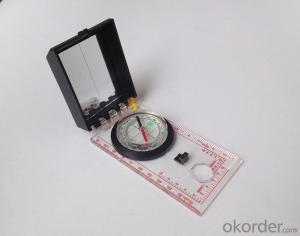
Product details
Model: DC45-5B
Name: Professional map compass, ruler compass
Product Origin: China
Supply Ability: 10,000 pcs/month
Minimum Order: 50 pcs
MOQ for OEM package: 500pcs
Product Size: 112*62*17 (mm)
Color: OEM
Features
1, professional usage: orientation, distance measuring, measuring slope, azimuth and pitching Angle measurement, drawing, a magnifying glass
2, high quality compass with neck rope, portable and rugged
3, ACRYLIC material, about 2mm thick
4, Damping Dial: to keep the stability of the pointer, more suitable for outdoor
environment.
5, Accuracy: accurate and clear, there were 360 degrees azimuth Angle, outer ring is 64-00 system, Liquid filled in the compass for reliable readings.
6, Magnifier function
- Q: What factors affect the handheld GPS receive signal?
- The United States Department of defense. A SA satellite signal to interference (the U.S. government for consideration of security of civil code of a called "selective availability (Selective SA Availability)" interference, to ensure the best protection system is effective. Because of the random error information added by SA in the navigation message, the positioning accuracy of the civil signal C/A code is reduced to about 100 meters. However, the use of differential GPS technology, the system error can be reduced to 10 to 15 metersTwo. Weather factors (including sunspots, bad weather, etc.) to reduce the intensity of the received signalThree. In buildings, vehicles, insulation paper, or metal shielding, GPS signal will be reduced or completely lost signal. In open spaces, GPS devices receive the best signal. .
- Q: My friend is in use, the difference is not big, professional handset (smart or Magellan bulky, but 3 case), but the price is expensive, but can not call and map is very rotten, endurance of 10 hours (dry battery) the mobile phone also has all the time. Know friends say, I mainly in the suburbs! Thanks
- Design ideas and the use of different objectsThe handheld is designed for military, mapping, mining, agriculture, outdoor sports (hiking, hiking, orienteering, cycling, water sports, paragliding, etc.).Cell phone navigation is designed to drive a car in the city, built-in interest points are mostly concentrated in the city.
- Q: Mountaineering to buy a professional GPS or Mountaineering Watch
- Can be downloaded in general maps, satellite maps, and even contour maps, which features far more than handheld GPS or mountain climbing watches, you can better meet the needs of mountaineering.
- Q: Hand held GPS coordinate conversion method
- Two. To coordinate the coordinate data of the control points obtained provide technical support unit of Beijing Unistrong companies around the branch responsible person to calculate the coordinate transformation parameters conversion parameters, or to obtain their own conversion conversion software. After the conversion parameters are calculated by the prompt input handheld GPS. Only after such a setup, after all the soil in the region when the coordinates of the GPS read out the coordinates of the point for the Beijing 54 coordinates.
- Q: What is GPS Mu meter ah, with the general said that the GPS measuring instrument what is the difference?
- GPS Mu meter also known as land area measuring instrument, handheld meter meter, etc.. Integrated computational methods for understanding and intelligent high precision GPS positioning system, the precise area of the handheld computer system, can realize the irregular area of real-time measurement and dynamic graphical display and intelligent data processing and storage.GPS measurement of the meter is different from the general GPS measuring instrument is based on the latitude and longitude of its area calculation function, general GPS is generally used for positioning.
- Q: GPS handheld function to measure it?
- Depends on the accuracy of the range you require, if the accuracy of the 3-5 meter can be used for ranging, measuring area, latitude and longitude, elevation information, etc.
- Q: In addition to the parameters, that is the problem of the machine, what method can reduce the error of these two machines to a minimum. Because, at the same time to find a coordinate. The gap is too big.
- GPS was in error with 10 meters, with the star search results, related to the environment, if the precision is high, as long as the use of handheld GPS submeter or handheld RTK
- Q: Handheld GPS purchaseHandheld GPS navigator!Is mainly used for tourism, I said is not a mobile phone, is a more professional handheld GPS navigator for travel outside! Handheld GPS navigator can voice navigation?
- If it is only used for general tourism, then hundreds of pieces of GPS is enough, go to the computer city to see, there must be sold, or go to your city to look at the outdoor store
- Q: How the German born handheld GPS Mu meter, I want to buy?
- The data acquisition function of scientific, simple and accurate measurement of area, display area and the "Mu", "price" area can be set automatically calculate the area of "price", fit the actual demand Chinese industry users on the data collection and usage, highlighting the professional quality.Is the highest cost-effective mid-range machine
- Q: Handheld GPS, the measurement of arable land, fixed point and circle test, which is more accurate,
- So for you to measure the area, some of the 3cm point error surrounded by the graphics area and some millimeter level point error surrounded by the graphics area is not much difference.
Send your message to us
Acrylic Map compass DC45-5B
- Ref Price:
-
- Loading Port:
- Tianjin
- Payment Terms:
- TT OR LC
- Min Order Qty:
- -
- Supply Capability:
- 5000 pc/month
OKorder Service Pledge
OKorder Financial Service
Similar products


Hot products


Hot Searches

