
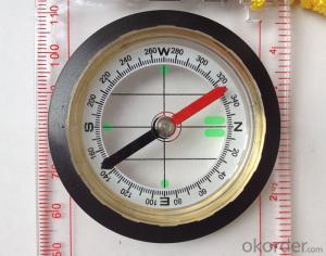
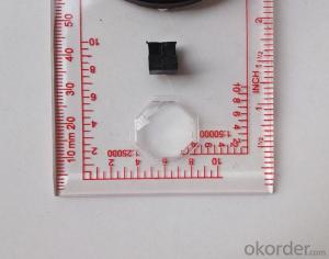
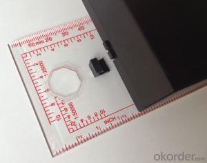


Acrylic Map compass DC45-6A
- Ref Price:
-

- Loading Port:
- Tianjin
- Payment Terms:
- TT OR LC
- Min Order Qty:
- -
- Supply Capability:
- 5000 pc/month
OKorder Service Pledge
OKorder Financial Service
You Might Also Like


Product details
Model: DC45-6A
Name: Professional map compass, ruler compass
Product Origin: China
Supply Ability: 10,000 pcs/month
Minimum Order: 50 pcs
MOQ for OEM package: 500pcs
Product Size: 122*61*22 (mm)
Color: OEM
Features
1, professional usage: orientation, distance measuring, measuring slope, azimuth and pitching Angle measurement, drawing, a magnifying glass
2, high quality compass with neck rope, portable and rugged
3, ACRYLIC material, about 2mm thick
4, Damping Dial: to keep the stability of the pointer, more suitable for outdoor
environment.
5, Accuracy: accurate and clear, there were 360 degrees azimuth Angle, outer ring is 64-00 system, Liquid filled in the compass for reliable readings.
6, Magnifier function
- Q: My friend is in use, the difference is not big, professional handset (smart or Magellan bulky, but 3 case), but the price is expensive, but can not call and map is very rotten, endurance of 10 hours (dry battery) the mobile phone also has all the time. Know friends say, I mainly in the suburbs! Thanks
- Two, different hardware configurationAs the field work environment is relatively poor, so waterproof, dustproof, shockproof for handheld GPS is very necessary. Handheld GPS on the market level of water is generally IPX7, and the continuous use of time is often more than 10 hours. Mobile phones are not so much demand. Handheld GPS function is relatively simple, and even most of the products are still grayscale display screen, multimedia features almost No.In the chip, there is not much difference between the GPS and GPS handheld mobile phone, mobile phone is commonly used in the Samsung 2440 chip and SIRF III receiving module on the handset is also very common, but in recent years MSTAR from Taiwan due to its advantages of cheap, very popular in the low-end handset.
- Q: Is it accurate to measure highway mileage with GPS handheld
- Can only say that the handheld GPS measurement of highway mileage can be a reference, if you want to measure the accuracy or sub meter level or professional measuring tools better
- Q: Handheld GPS navigation is what? Where to buy handheld GPS navigation, how to select GPS navigation?
- Handheld GPS navigator, also known as portable navigator, but also divided into 2 kinds, one is the ordinary PND navigator, you can go to Zhongguancun, the major appliance stores to buy, and the other is the mobile navigation, GPS smart phone is installed in the GPS navigation software can be,The navigator is composed of 2 parts: hardware and navigation software. The navigator on the market is about RMB 600. The brand of Kelid navigation software is usedGPS is a portable handheld navigation navigation products, the market is now very much, most car navigation can be used, the Gps signal is still free to receive satellite signals in the United States, you only need to charge it, map to the sellers in general can be upgraded.
- Q: Seeking the similarities and differences between RTK and GPS
- GPS: is the satellite positioning system in general, narrow sense refers to the GPS satellite, and the narrow sense refers to all can receive GPS signal equipment; RTK refers to the dynamic real time difference measurement, it also refers to the difference can be used for real-time dynamic measurement equipment. The difference between the two measurements from speaking: GPS contains RTK, also includes some precision lower grade equipment, such as the Garmin handset, handset, GPS meter level navigation etc..
- Q: What is the difference between the phone's GPS and professional handheld GPS features and differences?
- With more professional and more accurate positioning but are generally used dry batteries or rechargeable batteries not built-in rechargeable battery that is because handheld GPS users are mostly investigation or walk tourists convenient in use and emphasizes there is screen are generally of low power consumption for general color screen can only convey longitude and altitude mobile phone GPS is just a subsidiary function loading car navigation map
- Q: I am a handheld GPS precision is low, how to use to be able to improve certain accuracy.
- If you can join the CORS network, the accuracy of decimeter to centimeter level.
- Q: What is GPS Mu meter ah, with the general said that the GPS measuring instrument what is the difference?
- GPS Mu meter also known as land area measuring instrument, handheld meter meter, etc.. Integrated computational methods for understanding and intelligent high precision GPS positioning system, the precise area of the handheld computer system, can realize the irregular area of real-time measurement and dynamic graphical display and intelligent data processing and storage.GPS measurement of the meter is different from the general GPS measuring instrument is based on the latitude and longitude of its area calculation function, general GPS is generally used for positioning.
- Q: Handheld GPS charge is not into electricity what is the reason
- 3, restore the factory settings to see whether the system is.4, the battery damage, can replace the battery repair.
- Q: Handheld GPS and mobile phone GPS what is the difference?
- Handheld GPS also supports GPS compass navigation and map navigation as well as other more professional GPS applications; mobile GPS can work with fewer, more consumer grade product applications
- Q: How to upgrade handheld navigator
- Recommend the use of mobile map navigation.Chasing the answerEasy upgrade.
Send your message to us
Acrylic Map compass DC45-6A
- Ref Price:
-
- Loading Port:
- Tianjin
- Payment Terms:
- TT OR LC
- Min Order Qty:
- -
- Supply Capability:
- 5000 pc/month
OKorder Service Pledge
OKorder Financial Service
Similar products


Hot products


Hot Searches

