


Map compass DC47-2
- Ref Price:
-

- Loading Port:
- Tianjin
- Payment Terms:
- TT OR LC
- Min Order Qty:
- -
- Supply Capability:
- 5000 pc/month
OKorder Service Pledge
OKorder Financial Service
You Might Also Like


Product details
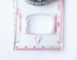
Model: DC47-2
Name: Professional map compass, ruler compass
Product Origin: China
Supply Ability: 10,000 pcs/month
Minimum Order: 50 pcs
MOQ for OEM package: 500pcs
Product Size: 115*55*11 (mm)
Color: OEM
Features
1, professional usage: orientation, distance measuring, measuring slope, azimuth and pitching Angle measurement, drawing, a magnifying glass
2, high quality compass with neck rope, portable and rugged
3, ACRYLIC material, about 2mm thick
4, Damping Dial: to keep the stability of the pointer, more suitable for outdoor
environment.
5, Accuracy: accurate and clear, there were 360 degrees azimuth Angle, outer ring is 64-00 system, Liquid filled in the compass for reliable readings.
6, Magnifier function
- Q: Handheld GPS positioning, can be directly uploaded to the computer, and the computer has a scalable map to mark the upload point. The above system, now there are 20Such as the title, I want to achieve the final function: through the manual to a point, with a hand-held GPS locator will be recorded in the specific latitude and longitude, and sent to the network in real time, for my computer to mark these points on the map. If you can directly enter the site of some of the information, directly to the above is the bestIf you have the above equipment, please indicate the scientific name, and the specific application industry.Thanks.
- The main function of Siwei Hin GPS map tag software1 support Google online (offline) hybrid satellite maps and general maps.2 support 1-18 level map arbitrary scaling, the left mouse button drag roaming.3 support the name of the query location, you can enter the location of the location after the location of the query.
- Q: Handheld GPS need to put the phone card?
- Hello, now the general GPS are required to put the card! Thanks
- Q: Can you buy a good handheld GPS in China? FiveTrouble master recommended several professional handheld GPS brand, in addition to handheld GPS can speed it? Thank you!!
- The main function is to use navigation as long as the navigation function can be used
- Q: Handheld GPS navigation is what? Where to buy handheld GPS navigation, how to select GPS navigation?
- Select the main consideration of the following issues on the line:1, GPS receiving capacity, in the interior, the streets can be measured on a few stars, while looking at the speed of the search star? If a place for 2 - 3 minutes accurate positioning can be used2, the map is the latest, often used to check those routes3, battery life is how long to ask4, accessories, such as support, car charge, the size of the memory card should be clearly presentedThe location of the purchase is usually in the car decoration department or the electronic mall or digital products store salesAffordable mall can look at the old brand, operating for many years, where I bought the electronic dog
- Q: Can a handheld navigator connect a cell phone? Thank you
- Open the phone hotspot WiFi, handheld navigator connected to this wifi.
- Q: Handheld GPS which brand is good
- Now GPS can also do handheld measurement accuracy, precision can usually reach decimeter level, the industry there are relatively well-known Huace, professional GPS measurement instrument, high precision of handheld GPS the good.
- Q: GPS handheld function to measure it?
- Depends on the accuracy of the range you require, if the accuracy of the 3-5 meter can be used for ranging, measuring area, latitude and longitude, elevation information, etc.
- Q: How to use the handheld GPS whole watershed investigation
- Therefore, it is an important method to solve the maximum value in physics by solving the maximum and minimum values of the physical quantity by the critical state.
- Q: Saying that we have a project in front of it is to do so, it is surprising that there are wood
- To 3D GPS it is not easy to find the map
- Q: How to upgrade handheld navigator
- Recommend the use of mobile map navigation.Chasing the answerEasy upgrade.
Send your message to us
Map compass DC47-2
- Ref Price:
-
- Loading Port:
- Tianjin
- Payment Terms:
- TT OR LC
- Min Order Qty:
- -
- Supply Capability:
- 5000 pc/month
OKorder Service Pledge
OKorder Financial Service
Similar products


Hot products


Hot Searches

