


Map Scale Compass DC47
- Ref Price:
-

- Loading Port:
- China Main Port
- Payment Terms:
- TT OR LC
- Min Order Qty:
- -
- Supply Capability:
- -
OKorder Service Pledge
OKorder Financial Service
You Might Also Like


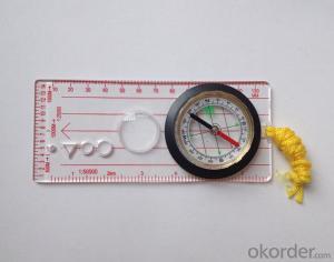
Model: DC47
Name: Professional map compass, ruler compass
Product Origin: China
Supply Ability: 10,000 pcs/month
Minimum Order: 50 pcs
MOQ for OEM package: 500pcs
Product Size: 115*55*11 (mm)
Features
1, professional usage: orientation, distance measuring, measuring slope, azimuth and pitching Angle measurement, drawing, a magnifying glass
2, high quality compass with neck rope, portable and rugged
3, ACRYLIC material, about 2mm thick
4, Damping Dial: to keep the stability of the pointer, more suitable for outdoor
environment.
5, Accuracy: accurate and clear, there were 360 degrees azimuth Angle, outer ring is 64-00 system, Liquid filled in the compass for reliable readings.
Payment term: TT/ LC
- Q: I would like to ask the GPS handset and GPS receiver (Surveying and mapping qualification application needs) is there a difference? If yes, what is the difference?
- This is the case, GPS handheld refers to a thin hand, while the GPS receiver refers to the RTK host, equivalent to the base station in our industry said. The general application of Surveying and mapping qualifications are required for this application, referred to as RTK (1+1) set, level, theodolite, total station, walkie talkie, technical personnel.... And so on, are essential equipment.
- Q: Handheld GPS locator measuring accuracy is about how many meters?
- The handheld machine precision is generally divided into: centimeter decimeter level, 1 meters, 2 meters, 3 meters, 5 meters; the precision is higher, the higher the price. You can consult the Haida official website "mobile MGIS mall".
- Q: Mountaineering to buy a professional GPS or Mountaineering Watch
- Can be downloaded in general maps, satellite maps, and even contour maps, which features far more than handheld GPS or mountain climbing watches, you can better meet the needs of mountaineering.
- Q: GPS handheld function to measure it?
- It depends on what kind of GPS handset. Some machines have this feature.
- Q: My cell phone: HTC Hero 200Question type: Internet softwareMy work needs to locate, record, output, and input GPS coordinates. Track record measurement, coordinate transformation. So would you have a professional security software under the table, so go out with a mobile phone or a PAD, or N equipment back to survey the tired,
- Taobao to enter the online shopping, mobile phone navigator on the line, I suggest you download the Careland navigation map, or tiger map
- Q: Handheld GPS and mobile phone GPS what is the difference?
- Handheld GPS also supports GPS compass navigation and map navigation as well as other more professional GPS applications; mobile GPS can work with fewer, more consumer grade product applications
- Q: What do you need to test for GPS?
- As a high-tech product, GPS has a very complex technical parameters. However, as people's living standards improved rapidly, more and more ordinary people began to pay attention to the positioning and navigation tools originated from the military. Because the convenience it brings is unprecedented. In order to let everyone out of all the technical parameters of GPS receiver, no longer confused at the time of purchase, the author selected six of the most important technical indicators, one by one to explain to you. 1 parallel channels on the market most of the GPS receiver is a 8 channel, 12 channel, the 16 channel, which allows them to continuously track the information of each satellite. Some GPS devices only have 2 to 5 parallel channel receiving satellite signals, because the average of 8 satellites are visible, which means that the GPS receiver must visit each of the satellites in order to obtain information about each satellite. All of our products are in Shenzhen channel 16 channel, multi-channel parallel GPS receiver, including the advantages of rapid cold start and initialization of satellite information, but also in the forest area can have a better reception. General 12 channel receiver does not require an external antenna, unless you are in a bad environment conditions such as closed space, such as the cabin, the car. 2 the sensitivity of the GPS satellite signal to the ground has been very weak, as well as ground wireless communication clutter interference. The lowest traceable signal strength of the GPS receiver determines how much useful signal is received. A GPS receiver with a lower minimum tracking signal strength has a higher sensitivity, and can receive more available satellites under bad conditions
- Q: Saying that we have a project in front of it is to do so, it is surprising that there are wood
- To 3D GPS it is not easy to find the map
- Q: How about the accuracy of the GPS handset?
- So the selection depends on your needs the function and budget. Haida official website mall "mobile MGIS mall".
- Q: Handheld GPS purchaseHandheld GPS navigator!Is mainly used for tourism, I said is not a mobile phone, is a more professional handheld GPS navigator for travel outside! Handheld GPS navigator can voice navigation?
- The more high-end is good, clever and wheat zalun, many outdoor enthusiasts are used to this, hiking, cycling and other applications are relatively wide, is an American brand, Mazelen returned to the U.S. Army GPS, and as Ma Ying-Jeou ring when riding on the handlebar also puts a high out of this two 60CSX. the brand in the nature, the price is more expensive, in more than 2000, but the best is to the store to buy.
Send your message to us
Map Scale Compass DC47
- Ref Price:
-
- Loading Port:
- China Main Port
- Payment Terms:
- TT OR LC
- Min Order Qty:
- -
- Supply Capability:
- -
OKorder Service Pledge
OKorder Financial Service
Similar products


Hot products


Hot Searches
Related keywords

