


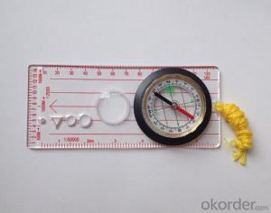
Transparant Map Scale Compass DC47-2
- Ref Price:
-

- Loading Port:
- China Main Port
- Payment Terms:
- TT OR LC
- Min Order Qty:
- -
- Supply Capability:
- -
OKorder Service Pledge
OKorder Financial Service
You Might Also Like


Model: DC47-2
Name: Professional map compass, ruler compass
Product Origin: China
Supply Ability: 10,000 pcs/month
Minimum Order: 50 pcs
MOQ for OEM package: 500pcs
Product Size: 115*55*11 (mm)
Features
1, professional usage: orientation, distance measuring, measuring slope, azimuth and pitching Angle measurement, drawing, a magnifying glass
2, high quality compass with neck rope, portable and rugged
3, ACRYLIC material, about 2mm thick
4, Damping Dial: to keep the stability of the pointer, more suitable for outdoor
environment.
5, Accuracy: accurate and clear, there were 360 degrees azimuth Angle, outer ring is 64-00 system, Liquid filled in the compass for reliable readings.
6, Magnifier function
- Q: Highway measurement with GPS I do not know which of the base station settings and mobile station settings I are very vague, to the instrument to build a coordinate system how to build the relevant issues to me
- Defects of conventional measurement methods:1, the specification of the length of the attached wire, the length of the wire and the length of the wire between the nodes have strict requirements, generally for high grade roads are required to meet the requirements of the first line. In this way, the length of the wire shall not be more than 10 km, or the length of the wire shall not exceed the length of the wire attached to the attachment of the wire length of 0.7 times. This requirement is generally difficult to achieve in the actual work, often appear super standardized operations.2, to collect the starting point for the general route of measurement and control is difficult to ensure the same measurement system, the measurement and measurement, often in the city of control points mixed together, the compatibility between systems, if the starting point is not compatible, is bound to affect the quality of measurement.3, serious damage to the national site, the impact of measurement operations. Due to the country's basic control points, mostly completed in 50s and 60s, after more than 30 years, some point due to the needs of economic construction is destroyed, and some people because of the lack of knowledge of human destruction. Route survey work in these areas, often in the 50 km above all can not find the wire control points. The quality of the route control survey is not guaranteed.4, ground visibility difficulties often affect the implementation of conventional measurement. The control points of the general route shall be located within 300 meters from the course. Due to visibility reasons, it is difficult to meet the conditions, even in a large range, and the dense shrub forest area, simply can not implement conventional control measure.
- Q: Handheld GPS how to achieve decimeter
- Hello A GPS is not up to the requirements of the class, if no one can buy that expensive submeter GPS, currently on the market with the best precision is GPS, is Derek GARMIN this year a new eTrex 10, 20 and 30, the three can be reached within 3 meters accuracy, you can look at
- Q: What is the difference between the phone's GPS and professional handheld GPS features and differences?
- But because it is a built-in or external Bluetooth GPS so the accuracy is not good at least a few meters there will be a gap drift phenomenon is simple said you drive open what is displayed on the screen of your car has been in the car to go outside for a while after a while back lane unstable and power consumption a larger say to you if you are a fresh hand if there is WM or Symbian system that will buy a mobile phone Bluetooth GPS module in Internet search navigation software can be installed navigation
- Q: Handheld GPS which brand is good
- Now GPS can also do handheld measurement accuracy, precision can usually reach decimeter level, the industry there are relatively well-known Huace, professional GPS measurement instrument, high precision of handheld GPS the good.
- Q: What is the difference between a hand-held GPS and a car's onboard navigator
- As the first floor of a friend to answer the same, the general application of hand-held devices in land surveying, mountain climbing and other precise positioning when measuring the use of. Long standby time, three good performance. Easy to carry. A single charge can be used for a long time (depending on the machine). Although navigation, but the map is not detailed. At the same time, there is an opportunity to have latitude, latitude and other information.The car navigation is designed for users to drive out, in the field when not familiar with the road, ah, not familiar with the surrounding buildings, such as parking, hospitals, restaurants, gas stations. Used. Map details. But does not provide information such as latitude accuracy. No elevation.Look what you're doing. There is also a mobile phone navigation function.If you are purely for entertainment, then choose the phone.If you want to navigate in the car, select the vehicle navigation.If you are a very professional outdoor sports enthusiasts on the choice of handheld.
- Q: Welcome to make comments on the existing GPS tour pal what shortcomings to answer the more detailed the better
- The first three factors: ability as a good tour pal, sun and rain fearless tramp over mountains and through ravines Rulvpingdi, GPS, his nature can not be weak, small knock a small touch can not have temper, off or out in the water dirty, also to be able to continue the work. So the waterproof / earthquake / dust and other indicators become the primary consideration factors GPS these are the protective ability of vehicle GPS, most of them do not have, and some professional GPS design, there will be more conducive to the harsh environment, such as some of the products designed to be capable of floating after falling into the water. The outdoor need to step back. What is it, if you can not do to prevent flooding, then rain proof ability is the minimum requirement.
- Q: The navigation module it is "selph" three generation? Another one I mainly use it to measure the land area, easy to use, the error is not big?I want to buy Magellan 500 do not know whether it is good to use
- Can only use professional GPS measuring instrument! Magellan and SIBAO!
- Q: Ask how to select a google satellite map into a handheld Area GPS
- The ordinary mobile phone GPS, can install Orville interactive map support pre download any regional satellite map, support for offline use
- Q: Handheld GPS each brand has what difference; different price difference in where is the positioning accuracy is different or what function is not the same?What are the differences between the measurements and the cars?
- Where the speed of the car, how many miles are open at a glance at the professional GPS locator
- Q: What is the difference between professional navigation and professional GPS navigator
- You can understand the principle of the radio transmitter receiver radio information, is not charged. GPS only in the need to track and special needs, and through the GSM network data is to receive GPRS traffic charges. Upgrade the main map of the general manufacturers do not charge. Now there are many kinds of vehicle navigation systems, different brands and various functions....Now we have to find a good brand navigation.....I hear people say it's a good way...A Thunis brand navigator is a hot productNow to the car navigator has a lot of MP3, MP4 and other entertainment features,,,,Fixed speed, movement speed and other functions....It is best to have a rear view, and, more secure.... GPS Car Navigator, simply said, is the navigator can help users to accurately locate the current position, and according to the established objective calculation of stroke by map display driving auxiliary equipment and voice prompt two ways to guide the user to the destination. It includes two important components: one is the global positioning system (Global Positioning System) referred to as GPSSuggest that you buy a professional GPS, after all, the phone's function is to call.
Send your message to us
Transparant Map Scale Compass DC47-2
- Ref Price:
-
- Loading Port:
- China Main Port
- Payment Terms:
- TT OR LC
- Min Order Qty:
- -
- Supply Capability:
- -
OKorder Service Pledge
OKorder Financial Service
Similar products


Hot products


Hot Searches
Related keywords

