


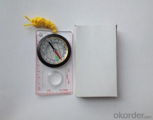
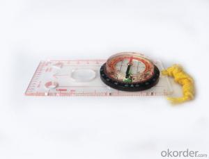
Mini Mapping Scale Compass for Surveying
- Ref Price:
-

- Loading Port:
- Tianjin
- Payment Terms:
- TT OR LC
- Min Order Qty:
- 50 pc
- Supply Capability:
- 10000 pc/month
OKorder Service Pledge
OKorder Financial Service
You Might Also Like


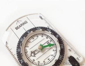
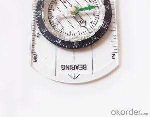
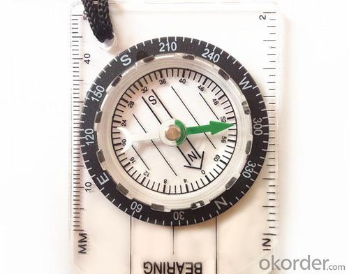
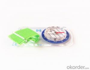
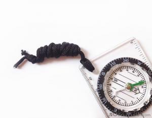
Structure of Mapping Compass Discription:
Model: DC35-1B
Name: Professional map compass, ruler compass
Product Origin: China
Supply Ability: 10,000 pcs/month
Minimum Order: 50 pcs
MOQ for OEM package: 500pcs
Main Features of Mapping Compass:
1, professional usage: orientation, distance measuring, measuring slope, azimuth and pitching Angle measurement, drawing, a magnifying glass
2, high quality compass with neck rope, portable and rugged
3, ACRYLIC material, about 2mm thick
4, Damping Dial: to keep the stability of the pointer, more suitable for outdoor
environment.
5, Accuracy: accurate and clear, there were 360 degrees azimuth Angle, outer ring is 64-00 system, Liquid filled in the compass for reliable readings.
6, Magnifier function
5, with ruler on compass DC45-5B,
6,for map measure and drawing
7,one meter neck rope,
8,Liquid filled in the compass for reliable readings,
9, magnifier function.
10,night vision map compass
Mapping Compss Images:


Map Scale Compass Specification:
Product Size: 70*48*9(mm)
Color: OEM
FAQ of Map Scale Compass:
1,What is the warranty for this product?
3 months after receiving the device.
2,How long could we get the goods?
Within one week after payment, the product will be sent out.
3,Do you have service centers abroad?
No.The service centers are in China at present.
- Q: Handheld GPS locator measuring accuracy is about how many meters?
- The higher the accuracy, the higher the price. You can consult the Haida official website mobile MGIS mall
- Q: Handheld GPS navigation is what? Where to buy handheld GPS navigation, how to select GPS navigation?
- Handheld GPS navigator, also known as portable navigator, but also divided into 2 kinds, one is the ordinary PND navigator, you can go to Zhongguancun, the major appliance stores to buy, and the other is the mobile navigation, GPS smart phone is installed in the GPS navigation software can be,The navigator is composed of 2 parts: hardware and navigation software. The navigator on the market is about RMB 600. The brand of Kelid navigation software is usedGPS is a portable handheld navigation navigation products, the market is now very much, most car navigation can be used, the Gps signal is still free to receive satellite signals in the United States, you only need to charge it, map to the sellers in general can be upgraded.
- Q: How to set the handheld GPS related parameters and coordinate conversion parameters throughout the country
- Two. To coordinate the coordinate data of the control points obtained provide technical support unit of Beijing Unistrong companies around the branch responsible person to calculate the coordinate transformation parameters conversion parameters, or to obtain their own conversion conversion software. After the conversion parameters are calculated by the prompt input handheld GPS. Only after such a setup, after all the soil in the region when the coordinates of the GPS read out the coordinates of the point for the Beijing 54 coordinates.
- Q: What is the difference between the phone's GPS and professional handheld GPS features and differences?
- With more professional and more accurate positioning but are generally used dry batteries or rechargeable batteries not built-in rechargeable battery that is because handheld GPS users are mostly investigation or walk tourists convenient in use and emphasizes there is screen are generally of low power consumption for general color screen can only convey longitude and altitude mobile phone GPS is just a subsidiary function loading car navigation map
- Q: Can a handheld navigator connect a cell phone? Thank you
- Mobile navigator can downloadOther purchases can not beNow basically use the phoneEasy update and operation
- Q: My cell phone: HTC Hero 200Question type: Internet softwareMy work needs to locate, record, output, and input GPS coordinates. Track record measurement, coordinate transformation. So would you have a professional security software under the table, so go out with a mobile phone or a PAD, or N equipment back to survey the tired,
- Taobao to enter the online shopping, mobile phone navigator on the line, I suggest you download the Careland navigation map, or tiger map
- Q: Welcome to make comments on the existing GPS tour pal what shortcomings to answer the more detailed the better
- Fifth elements: the terrain map is the main project of outdoor sports climbing, mountain climbing is very exhausting, we usually do a plan will be completed on schedule, a good plan should be to our destination in the manual run out before. And if you want to do this, it must be on the road difficult to have a correct anticipation. But this time, with the terrain map GPS can come in handy, the mountains and the altitude of the understanding, we need to know about these sections spend much time and energy. And the general GPS map, is unable to meet the needs. So we'd better buy a map with contour terrain data of professional grade GPS, make your own outdoor journey do in our hands.
- Q: What do you need to test for GPS?
- As a high-tech product, GPS has a very complex technical parameters. However, as people's living standards improved rapidly, more and more ordinary people began to pay attention to the positioning and navigation tools originated from the military. Because the convenience it brings is unprecedented. In order to let everyone out of all the technical parameters of GPS receiver, no longer confused at the time of purchase, the author selected six of the most important technical indicators, one by one to explain to you. 1 parallel channels on the market most of the GPS receiver is a 8 channel, 12 channel, the 16 channel, which allows them to continuously track the information of each satellite. Some GPS devices only have 2 to 5 parallel channel receiving satellite signals, because the average of 8 satellites are visible, which means that the GPS receiver must visit each of the satellites in order to obtain information about each satellite. All of our products are in Shenzhen channel 16 channel, multi-channel parallel GPS receiver, including the advantages of rapid cold start and initialization of satellite information, but also in the forest area can have a better reception. General 12 channel receiver does not require an external antenna, unless you are in a bad environment conditions such as closed space, such as the cabin, the car. 2 the sensitivity of the GPS satellite signal to the ground has been very weak, as well as ground wireless communication clutter interference. The lowest traceable signal strength of the GPS receiver determines how much useful signal is received. A GPS receiver with a lower minimum tracking signal strength has a higher sensitivity, and can receive more available satellites under bad conditions
- Q: Fuxin coordinates with the mapping of the seven parameters are what ah there is no professional knowledge to tell my brother I need to fill the gps... Thanks.
- XYZ offset, XYZ twist, 6, plus a scaling factor.Seven parameters have to be calculated, or from the local surveying and mapping departments to.
- Q: What qualifications should a normal GPS locator have?
- Patent, business licenseLook what kind of
Send your message to us
Mini Mapping Scale Compass for Surveying
- Ref Price:
-
- Loading Port:
- Tianjin
- Payment Terms:
- TT OR LC
- Min Order Qty:
- 50 pc
- Supply Capability:
- 10000 pc/month
OKorder Service Pledge
OKorder Financial Service
Similar products


Hot products


Hot Searches
Related keywords

