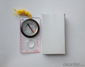


Good Mapor Ruler Mini-Compass for Surveying
- Ref Price:
-

- Loading Port:
- Tianjin
- Payment Terms:
- TT OR LC
- Min Order Qty:
- 20 pc
- Supply Capability:
- 10000 pc/month
OKorder Service Pledge
OKorder Financial Service
You Might Also Like


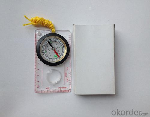
Model: DC45-5A
Name: Professional map compass, ruler compass
Product Origin: China
Supply Ability: 10,000 pcs/month
Minimum Order: 20 pcs
MOQ for OEM package: 500pcs
Product Size: 108*61*16 (mm)
Features of DC45-5A
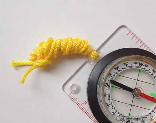
1, professional usage: orientation, distance measuring, measuring slope, azimuth and pitching Angle measurement, drawing, a magnifying glass
2, high quality compass with neck rope, portable and rugged
3, ACRYLIC material, about 2mm thick
4, Damping Dial: to keep the stability of the pointer, more suitable for outdoor environment.
5, Accuracy: accurate and clear, there were 360 degrees azimuth Angle, outer ring is 64-00 system, Liquid filled in the compass for reliable readings.
6, Magnifier function
5,ruler compass,
6,for map measure and drawing
7,one meter neck rope,
8,Liquid filled in the compass for reliable readings,
9, magnifier function.
- Q: Handheld GPS positioning, can be directly uploaded to the computer, and the computer has a scalable map to mark the upload point. The above system, now there are 20Such as the title, I want to achieve the final function: through the manual to a point, with a hand-held GPS locator will be recorded in the specific latitude and longitude, and sent to the network in real time, for my computer to mark these points on the map. If you can directly enter the site of some of the information, directly to the above is the bestIf you have the above equipment, please indicate the scientific name, and the specific application industry.Thanks.
- The main function of Siwei Hin GPS map tag software1 support Google online (offline) hybrid satellite maps and general maps.2 support 1-18 level map arbitrary scaling, the left mouse button drag roaming.3 support the name of the query location, you can enter the location of the location after the location of the query.
- Q: Handheld GPS need to put the phone card?
- Hello, now the general GPS are required to put the card! Thanks
- Q: I bought the way k20s, this handheld GPS how
- Choi way handheld GPS feel that you can also be in the last year, the Zhengzhou Bureau of Surveying and mapping seems to be called the wide Han instrument that home to buy, so there is no problem with it, the price is not expensive.
- Q: Hand held GPS coordinate conversion method
- By the 84 coordinates to Beijing 54 Coordinate. A collection of application area of high grade control data in GPS receiver applied earth area (such as a county) find three (or more) uniform grade (accuracy better) or GPS "B" dot, point the best is around without interference of electromagnetic wave, vision, satellite signal. To the local surveying and mapping management department (such as: the local bureau of Surveying and mapping, surveying and Mapping Institute) Gauss plane coordinate copy these points of the Beijing 54 Coordinate System (x, y), the elevation of H and WGS-84 coordinates of the geodetic coordinates (B, L), the high H.
- Q: GPS handheld function to measure it?
- Depends on the accuracy of the range you require, if the accuracy of the 3-5 meter can be used for ranging, measuring area, latitude and longitude, elevation information, etc.
- Q: My cell phone: HTC Hero 200Question type: Internet softwareMy work needs to locate, record, output, and input GPS coordinates. Track record measurement, coordinate transformation. So would you have a professional security software under the table, so go out with a mobile phone or a PAD, or N equipment back to survey the tired,
- Taobao to enter the online shopping, mobile phone navigator on the line, I suggest you download the Careland navigation map, or tiger map
- Q: Handheld GPS and mobile phone GPS what is the difference?
- The same: GPS main chip may be the same; can complete the GPS positioning;
- Q: The navigation module it is "selph" three generation? Another one I mainly use it to measure the land area, easy to use, the error is not big?I want to buy Magellan 500 do not know whether it is good to use
- A type specific.GPS chip area measurement is the most "selph" 3 generation, special machine is very good, the error is very small.
- Q: Magellan GPS handheld why so many people choose not to say that the map is not good
- Outdoor use three times a year also on the trip, but also want to use both sides can be used to the best, so these are the best of the two Ming and Magellan did not know that the election of the good, but I am willing to build businesses with the best Ming of the 450.Chasing the answerIf only in the city with less than 610510 can be upgraded Magellan navigation, 610 more than and 510 three axis electronic compass if you don't like the original forest does not receive any signal where there is no whatTake a look at yourself
- Q: What is the difference between professional navigation and professional GPS navigator
- 5 price of less than 3000 yuan.> 4, 5 a answer: there are PDAGPS mobile phone development, but should be more than 6000. One of the PDAGPS generally above 3000, generally have more than 3000 car navigation. If you have Bluetooth support PDA or PDA phone, plus a Bluetooth GPS is as long as 1000 or so. So the first three choices and then you have only the following three choices: first, the new machine but the older models, businesses dumped, and the other is to know the people, and the three is a vintage.More well-known brands in the market: Taiwan (MIO), the new branch, Taiwan HOLUX long days, GARMIN, HP, etc.PDAGPS mobile phone: MIO A700, E, TATO588, HP6515PDAGPS development: MIO168, 169, 269, P350, HOLUX PolarisVehicle navigation: MIO C210, new section four or five, GARMIN three or four
Send your message to us
Good Mapor Ruler Mini-Compass for Surveying
- Ref Price:
-
- Loading Port:
- Tianjin
- Payment Terms:
- TT OR LC
- Min Order Qty:
- 20 pc
- Supply Capability:
- 10000 pc/month
OKorder Service Pledge
OKorder Financial Service
Similar products


Hot products


Hot Searches

