
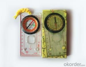


Professional Map or Ruler Mini-Compass DC45-C for Surveying
- Ref Price:
-

- Loading Port:
- Tianjin
- Payment Terms:
- TT OR LC
- Min Order Qty:
- 20 pc
- Supply Capability:
- 10000 pc/month
OKorder Service Pledge
OKorder Financial Service
You Might Also Like


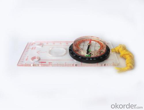
Model: DC45-5C
Name: Professional map compass, ruler compass
Product Origin: China
Supply Ability: 10,000 pcs/month
Minimum Order: 20 pcs
MOQ for OEM package: 500pcs
Product Size: 128*60*16 (mm)
Features of DC45-5C
1, professional usage: orientation, distance measuring, measuring slope, azimuth and pitching Angle measurement, drawing, a magnifying glass
2, high quality compass with neck rope, portable and rugged
3, ACRYLIC material, about 2mm thick
4, Damping Dial: to keep the stability of the pointer, more suitable for outdoor environment.
5, Accuracy: accurate and clear, there were 360 degrees azimuth Angle, outer ring is 64-00 system, Liquid filled in the compass for reliable readings.
6, Magnifier function
5,ruler compass,
6,for map measure and drawing
7,one meter neck rope,
8,Liquid filled in the compass for reliable readings,
9, magnifier function.
- Q: I would like to ask the GPS handset and GPS receiver (Surveying and mapping qualification application needs) is there a difference? If yes, what is the difference?
- GPS handheld GPS operating manual, GPS receiver is to receive satellite signals, GPS consists of two components.
- Q: Handheld GPS buried in the soil there is a signal
- It depends on how deep you buried the darker the GPS signal, and must ensure that the GPS antenna upward, the above can not be covered with metal objects
- Q: I am ready to go to the field to go to college, but I do not know how to buy a handheld GPS, I hope you recommend. The most important thing is easy to carry.
- Younger brother, buy a smart phone, ranging from several hundred dollars to several thousand dollars, as long as the GPS module on the line, understand it?I'm not talking about it, as long as the smart phone with GPS module, you can use when GPS, can be used to drive, you can certainly use a walk. Even if there is no GPS die fast, with a cell phone signal can be positioned, but not too accurate. Hundreds of meters.In addition, you go to college, do not use smart phones, students are not afraid of jokes? Buy a Android system on the machine line. Cheap on a few hundred dollars.You say you take a hand-held machine, and then take a cell phone to go out, trouble is not trouble?
- Q: I bought the way k20s, this handheld GPS how
- Ordinary hand-held GPS is 3-5 meter accuracy, high accuracy can be achieved unless buy submeter ordinary user, if you can.
- Q: Handheld GPS charge is not into electricity what is the reason
- 3, restore the factory settings to see whether the system is.4, the battery damage, can replace the battery repair.
- Q: Handheld GPS and mobile phone GPS what is the difference?
- Different: antenna size, function, accuracy, protection level, and has been different in the application layer (handheld GPS support GPS compass navigation and map navigation and other more professional GPS applications);
- Q: What do you need to test for GPS?
- 6 antenna type to give you a good positioning, GPS receiver requires at least 3 ~ 5 satellites are visible. If you are in a canyon or on both sides of the street, or in the dense jungle, you may not be able to contact with enough satellites, so that you can not locate or only two-dimensional coordinates. Also, if you're in a building inside, you may not be able to update your location, some GPS receivers have a separate antenna can be attached to the windshield, or built-in active antenna, or an external active antenna can be placed on the roof, the receiver which helps you get more satellite signals the. 7 other indicators to buy GPS equipment, according to the needs and use of the environment, size, weight, waterproof, shockproof, dustproof performance, high temperature resistance, power consumption and other indicators should be taken into account.
- Q: How to hand GPS eTrex H data to the computer
- You have a data cable, the computer installed on the MapSource software, connect the computer and handheld GPS can transfer data!!!"Shaanxi skmax navigation information Limited" GARMIN proxy (GARMIN official website can be found), contact (Xiao Hou) the hope can help to you, if you do not understand what we see on the Internet, may at any time, contact us
- Q: Handheld GPS, the measurement of arable land, fixed point and circle test, which is more accurate,
- If the area is measured, are almost. However, if the measurement point is only the case, the dynamic GPS is now the general error can be guaranteed within 3cm, the total station can be guaranteed to the millimeter.
- Q: Handheld GPS each brand has what difference; different price difference in where is the positioning accuracy is different or what function is not the same?What are the differences between the measurements and the cars?
- Engage in measurement and what is the difference between the car I do not know, look at the car to see if the functionSMS + Mobile Internet + computer network platform! 3 ways to check the car!
Send your message to us
Professional Map or Ruler Mini-Compass DC45-C for Surveying
- Ref Price:
-
- Loading Port:
- Tianjin
- Payment Terms:
- TT OR LC
- Min Order Qty:
- 20 pc
- Supply Capability:
- 10000 pc/month
OKorder Service Pledge
OKorder Financial Service
Similar products


Hot products


Hot Searches

