


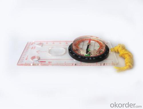


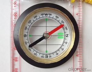
Professional Map Mini-Compass DC45-C for Surveying
- Ref Price:
-

- Loading Port:
- Tianjin
- Payment Terms:
- TT OR LC
- Min Order Qty:
- 20 pc
- Supply Capability:
- 10000 pc/month
OKorder Service Pledge
OKorder Financial Service
You Might Also Like


Model: DC45-5C
Name: Professional map compass, ruler compass
Product Origin: China
Supply Ability: 10,000 pcs/month
Minimum Order: 20 pcs
MOQ for OEM package: 500pcs
Product Size: 128*60*16 (mm)
Features of DC45-5C
1, professional usage: orientation, distance measuring, measuring slope, azimuth and pitching Angle measurement, drawing, a magnifying glass
2, high quality compass with neck rope, portable and rugged
3, ACRYLIC material, about 2mm thick
4, Damping Dial: to keep the stability of the pointer, more suitable for outdoor environment.
5, Accuracy: accurate and clear, there were 360 degrees azimuth Angle, outer ring is 64-00 system, Liquid filled in the compass for reliable readings.
6, Magnifier function
5,ruler compass,
6,for map measure and drawing
7,one meter neck rope,
8,Liquid filled in the compass for reliable readings,
9, magnifier function.
- Q: I would like to ask the GPS handset and GPS receiver (Surveying and mapping qualification application needs) is there a difference? If yes, what is the difference?
- 1. GPS is a geodetic instrument, with an accuracy of CM, generally for the millimeter,,Divided into (1) pure static type, such as the South Star of the North Star, the accuracy of mm, now the basic domestic,,(2) RTK, RTK can do is use, carrier phase measurement, the precision is cm level, RTK mobile station must have the control hand book, like television and remote similar, but now there are a lot of hand book can be used as handset2. The handset is generally rough field positioning equipment, navigation for mobile phone use, the general size, precision grade m, now can to about 20cm, and can be used for RTK mobile station use (need to access the base station) can reach cm level.Surveying and mapping qualification applications require geodetic measurement equipment, that is, 1.Now domestic GPS, such as the Haida, the south, China, etc. can be measured, not expensive
- Q: Handheld GPS need to put the phone card?
- Hello, now the general GPS are required to put the card! Thanks
- Q: GPS Mu meter which brand is good, handheld high-precision land area measuring instrument
- A German born mu can also recommend a good precision measuring instrument.
- Q: Is it accurate to measure highway mileage with GPS handheld
- Can only say that the handheld GPS measurement of highway mileage can be a reference, if you want to measure the accuracy or sub meter level or professional measuring tools better
- Q: Handheld GPS navigation is what? Where to buy handheld GPS navigation, how to select GPS navigation?
- Handheld GPS is mainly for GIS data acquisition, a lot of advanced GPS with PDA function, you can load navigation software for vehicle navigationBut the handheld GPS is mainly to do some engineering design, the main area can be measured, the location, and the boundary survey. GPS can do advanced vehicle navigation can also waypoint navigation, is a coordinate input to precise navigation to this position.Handheld GPS navigation is divided into 2 kinds, one is portable GPS navigation, one is used for surveying and mapping professional GPS handheld
- Q: Mobile GPS can replace professional handheld GPS
- No, the phone's GPS is used for navigation, professional handheld GPS is used for measurement. Navigation GPS cannot be used for measurement because of insufficient accuracy.
- Q: My cell phone: HTC Hero 200Question type: Internet softwareMy work needs to locate, record, output, and input GPS coordinates. Track record measurement, coordinate transformation. So would you have a professional security software under the table, so go out with a mobile phone or a PAD, or N equipment back to survey the tired,
- Taobao to enter the online shopping, mobile phone navigator on the line, I suggest you download the Careland navigation map, or tiger map
- Q: Fuxin coordinates with the mapping of the seven parameters are what ah there is no professional knowledge to tell my brother I need to fill the gps... Thanks.
- XYZ offset, XYZ twist, 6, plus a scaling factor.Seven parameters have to be calculated, or from the local surveying and mapping departments to.
- Q: I just bought a handheld GPS Magellan No. 1, showing the latitude and longitude coordinates, I want to set the geodetic coordinates of latitude and longitude, do not know where to set, I would like to ask you, how to set, there is a better picture shows the best, thank you so much.Magellan GPS 210 is not 2000 shy
- 2 map reference setting: [[map] - unit "benchmark is set to User, and input the DX, DY, DZ, DA, DF parameters, usually DX, DY, DZ vary from region to region, so need to know the high level control points to solve, solving methods are as follows:The handheld GPS is placed in the control point field buried pile, were measured, and then hand coordinate coordinates and the known control points of the GPS measurements obtained for the poor, can be obtained by local coordinates and elevation deviation value: DX, DY, DZ.
- Q: Handheld GPS, the measurement of arable land, fixed point and circle test, which is more accurate,
- If the measurement point is only the case, the dynamic GPS is now the general error can be guaranteed within 3cm, the total station can be guaranteed to the millimeter.
Send your message to us
Professional Map Mini-Compass DC45-C for Surveying
- Ref Price:
-
- Loading Port:
- Tianjin
- Payment Terms:
- TT OR LC
- Min Order Qty:
- 20 pc
- Supply Capability:
- 10000 pc/month
OKorder Service Pledge
OKorder Financial Service
Similar products


Hot products


Hot Searches

