


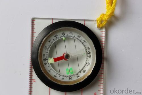


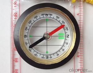
Professional Map Mini-Compass DC45-W for Surveying
- Ref Price:
-

- Loading Port:
- Tianjin
- Payment Terms:
- TT OR LC
- Min Order Qty:
- 20 pc
- Supply Capability:
- 10000 pc/month
OKorder Service Pledge
OKorder Financial Service
You Might Also Like


Model: DC45-5W
Name: Professional map compass, ruler compass
Product Origin: China
Supply Ability: 10,000 pcs/month
Minimum Order: 20 pcs
MOQ for OEM package: 500pcs
Product Size: 114*60.5*167(mm)
Features of DC45-5W
1, professional usage: orientation, distance measuring, measuring slope, azimuth and pitching Angle measurement, drawing, a magnifying glass
2, high quality compass with neck rope, portable and rugged
3, ACRYLIC material, about 2mm thick
4, Damping Dial: to keep the stability of the pointer, more suitable for outdoor environment.
5, Accuracy: accurate and clear, there were 360 degrees azimuth Angle, outer ring is 64-00 system, Liquid filled in the compass for reliable readings.
6, Magnifier function
5,ruler compass,
6,for map measure and drawing
7,one meter neck rope,
8,Liquid filled in the compass for reliable readings,
9, magnifier function.
- Q: Handheld GPS need to put the phone card?
- Travel GPS professional solutions:Put card. Will be equipped with a card at the time of purchase.
- Q: My friend is in use, the difference is not big, professional handset (smart or Magellan bulky, but 3 case), but the price is expensive, but can not call and map is very rotten, endurance of 10 hours (dry battery) the mobile phone also has all the time. Know friends say, I mainly in the suburbs! Thanks
- Two, different hardware configurationAs the field work environment is relatively poor, so waterproof, dustproof, shockproof for handheld GPS is very necessary. Handheld GPS on the market level of water is generally IPX7, and the continuous use of time is often more than 10 hours. Mobile phones are not so much demand. Handheld GPS function is relatively simple, and even most of the products are still grayscale display screen, multimedia features almost No.In the chip, there is not much difference between the GPS and GPS handheld mobile phone, mobile phone is commonly used in the Samsung 2440 chip and SIRF III receiving module on the handset is also very common, but in recent years MSTAR from Taiwan due to its advantages of cheap, very popular in the low-end handset.
- Q: Is it accurate to measure highway mileage with GPS handheld
- As long as you can receive more than four satellites, and the signal is good, the accuracy should be high.
- Q: Mountaineering to buy a professional GPS or Mountaineering Watch
- Can be downloaded in general maps, satellite maps, and even contour maps, which features far more than handheld GPS or mountain climbing watches, you can better meet the needs of mountaineering.
- Q: Jia Ming etre20 handheld GPS good
- Jia Ming eTrex 20 has an enhanced 2.2 inch screen, a color rendering effect of 65 thousand TFT, a readable display in the sun. Durable waterproof, but also upgraded the interface to retain the existing hardness and toughness, to withstand dust, dirt, moisture and water erosion, these are not the legendary navigator opponent.
- Q: Handheld GPS charge is not into electricity what is the reason
- 3, restore the factory settings to see whether the system is.4, the battery damage, can replace the battery repair.
- Q: How do I still stay in the GPS navigation, GPS monitoring of the primary idea? FiveBusiness services, thank you!Future business services
- 6 people travel and adventure7 personal communication terminal (with mobile phones, PDA, electronic map integration)8 time synchronization of electric power, post and telecommunication9 accurate timing of admission10 accurate frequency of admission
- Q: Welcome to make comments on the existing GPS tour pal what shortcomings to answer the more detailed the better
- Fifth elements: the terrain map is the main project of outdoor sports climbing, mountain climbing is very exhausting, we usually do a plan will be completed on schedule, a good plan should be to our destination in the manual run out before. And if you want to do this, it must be on the road difficult to have a correct anticipation. But this time, with the terrain map GPS can come in handy, the mountains and the altitude of the understanding, we need to know about these sections spend much time and energy. And the general GPS map, is unable to meet the needs. So we'd better buy a map with contour terrain data of professional grade GPS, make your own outdoor journey do in our hands.
- Q: How to hand GPS eTrex H data to the computer
- "Shaanxi skmax navigation information Limited" GARMIN proxy (GARMIN official website can be found), contact (Xiao Hou) the hope can help to you, if you do not understand what we see on the Internet, may at any time, contact us!
- Q: What qualifications should a normal GPS locator have?
- Patent, business licenseLook what kind of
Send your message to us
Professional Map Mini-Compass DC45-W for Surveying
- Ref Price:
-
- Loading Port:
- Tianjin
- Payment Terms:
- TT OR LC
- Min Order Qty:
- 20 pc
- Supply Capability:
- 10000 pc/month
OKorder Service Pledge
OKorder Financial Service
Similar products


Hot products


Hot Searches

