


Good Mapor Ruler Mini-Compass DC47-2 for Surveying
- Ref Price:
-

- Loading Port:
- Tianjin
- Payment Terms:
- TT OR LC
- Min Order Qty:
- 20 pc
- Supply Capability:
- 10000 pc/month
OKorder Service Pledge
OKorder Financial Service
You Might Also Like


Model: DC47-2
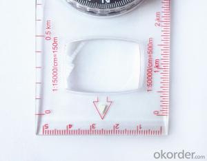
Name: Professional map compass, ruler compass
Product Origin: China
Supply Ability: 10,000 pcs/month
Minimum Order: 20 pcs
MOQ for OEM package: 500pcs
Product Size: 125.5*60.5*10 (mm)
Features of DC47-2
1, professional usage: orientation, distance measuring, measuring slope, azimuth and pitching Angle measurement, drawing, a magnifying glass
2, high quality compass with neck rope, portable and rugged
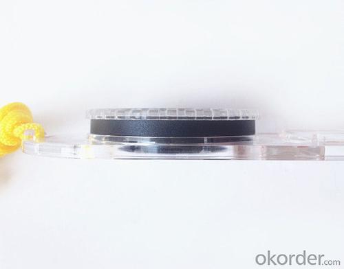
3, ACRYLIC material, about 2mm thick
4, Damping Dial: to keep the stability of the pointer, more suitable for outdoor environment.
5, Accuracy: accurate and clear, there were 360 degrees azimuth Angle, outer ring is 64-00 system, Liquid filled in the compass for reliable readings.
6, Magnifier function
5,ruler compass,
6,for map measure and drawing
7,one meter neck rope,
8,Liquid filled in the compass for reliable readings,
9, magnifier function.
- Q: Handheld GPS buried in the soil there is a signal
- It depends on how deep you buried the darker the GPS signal, and must ensure that the GPS antenna upward, the above can not be covered with metal objects
- Q: Handheld GPS how to achieve decimeter
- Hello A GPS is not up to the requirements of the class, if no one can buy that expensive submeter GPS, currently on the market with the best precision is GPS, is Derek GARMIN this year a new eTrex 10, 20 and 30, the three can be reached within 3 meters accuracy, you can look at
- Q: Can you buy a good handheld GPS in China? FiveTrouble master recommended several professional handheld GPS brand, in addition to handheld GPS can speed it? Thank you!!
- If it is used, there is no difference.
- Q: My friend is in use, the difference is not big, professional handset (smart or Magellan bulky, but 3 case), but the price is expensive, but can not call and map is very rotten, endurance of 10 hours (dry battery) the mobile phone also has all the time. Know friends say, I mainly in the suburbs! Thanks
- Professional GPS is mainly used for acquisition, is not used for navigation; of course, some professional GPS can install third party software, the accuracy is higher than the phone, this is positive;Mobile navigation is only used for navigation, navigation, path analysis and navigation functions, not the acquisition of maps of the instrument.
- Q: Handheld GPS locator measuring accuracy is about how many meters?
- The handheld machine precision is generally divided into: centimeter decimeter level, 1 meters, 2 meters, 3 meters, 5 meters; the precision is higher, the higher the price. You can consult the Haida official website "mobile MGIS mall".
- Q: What is the difference between professional GPS handsets and mobile navigation?
- GPS is the most important positioning accuracy. Professional handheld machine with industrial design. First of all, if used outdoors, then fell, and so on are likely to water, and this thing is also very expensive, so the opportunity to have a high professional anti shock waterproof performance.
- Q: Verify the accuracy of the GPS device to buy back, the way is to use Android under the'gps state 'software, to test the accuracy of real-time single point positioning.1 with two sets of the same Android Tablet Computer (custom machine, type of bad) in the same position for receiving, find that the accuracy is the same (software, are 1-2 meters), but the position would be poor 10 meters or more. It's in the same place.The 2 one is the Android tablet computer, a mobile phone is HTC G10, also received together in the same position, find that the accuracy is not the same as (the latter 20 meters or so), but also may be about 10 meters position difference.The accuracy of this GPS device can reach 1-2 meters, while the same location in real-time single point positioning error of 10 meters, a reasonable explanation.
- Oh, together with the exchange of learning, mutual verification, I said that is my experience. Software tells you that the accuracy is handled and limited, especially for some third party software. If you do not limit the scope of the conditions, the limit is too difficult to determine. If the satellite in poor condition, serious occlusion, satellite time difference, let alone ten meters, a few dozen a hundred meters are possible. Under normal circumstances, single point positioning accuracy is about ten meters, of course, sometimes all aspects of the conditions are very good, a few meters are also some. As for the accuracy of the GPS that you say htc10 and tablet computer, to this kind of navigation type GPS, from the respect of the respect that the instrument says, the accuracy should be in 10 meters to 15 meters (all the conditions are all right). Oh exchange!
- Q: How do I still stay in the GPS navigation, GPS monitoring of the primary idea? FiveBusiness services, thank you!Future business services
- 6 people travel and adventure7 personal communication terminal (with mobile phones, PDA, electronic map integration)8 time synchronization of electric power, post and telecommunication9 accurate timing of admission10 accurate frequency of admission
- Q: How about the accuracy of the GPS handset?
- So the selection depends on your needs the function and budget. Haida official website mall "mobile MGIS mall".
- Q: The navigation module it is "selph" three generation? Another one I mainly use it to measure the land area, easy to use, the error is not big?I want to buy Magellan 500 do not know whether it is good to use
- Can only use professional GPS measuring instrument! Magellan and SIBAO!
Send your message to us
Good Mapor Ruler Mini-Compass DC47-2 for Surveying
- Ref Price:
-
- Loading Port:
- Tianjin
- Payment Terms:
- TT OR LC
- Min Order Qty:
- 20 pc
- Supply Capability:
- 10000 pc/month
OKorder Service Pledge
OKorder Financial Service
Similar products


Hot products


Hot Searches

