


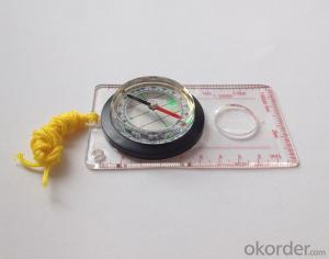
Map Scale Compass DC40-3A
- Ref Price:
-

- Loading Port:
- China Main Port
- Payment Terms:
- TT OR LC
- Min Order Qty:
- -
- Supply Capability:
- -
OKorder Service Pledge
OKorder Financial Service
You Might Also Like


Model: DC40-3A
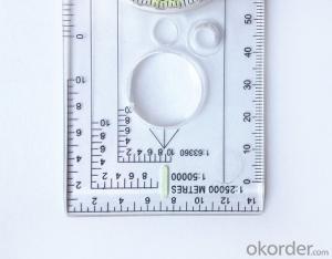
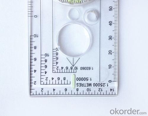
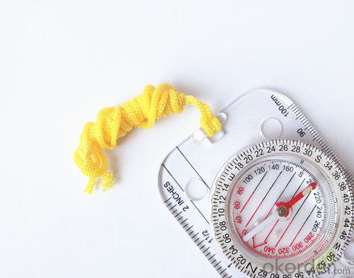
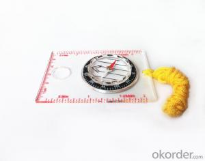
Name: Professional map compass, ruler compass
Product Origin: China
MOQ for OEM package: 500pcs
Product Size: 126*60*10 (mm)
Features
1, professional usage: orientation, distance measuring, measuring slope, azimuth and pitching Angle measurement,
2, high quality compass with neck rope, portable and rugged
3, ACRYLIC material, about 2mm thick
4, Damping Dial: to keep the stability of the pointer, more suitable for outdoor
environment.
5, Accuracy: accurate and clear, there were 360 degrees azimuth Angle, outer ring is 64-00 system, Liquid filled in the compass for reliable readings.
- Q: How to set the handheld GPS related parameters and coordinate conversion parameters throughout the country
- Two. To coordinate the coordinate data of the control points obtained provide technical support unit of Beijing Unistrong companies around the branch responsible person to calculate the coordinate transformation parameters conversion parameters, or to obtain their own conversion conversion software. After the conversion parameters are calculated by the prompt input handheld GPS. Only after such a setup, after all the soil in the region when the coordinates of the GPS read out the coordinates of the point for the Beijing 54 coordinates.
- Q: Handheld GPS which brand is good
- Now GPS can also do handheld measurement accuracy, precision can usually reach decimeter level, the industry there are relatively well-known Huace, professional GPS measurement instrument, high precision of handheld GPS the good.
- Q: What is the difference between a hand-held GPS and a car's onboard navigator
- Effect of GPS navigation handheld as vehicle, as the vehicle with what map, the hand-held GPS is mainly used for point positioning, measuring area, high precision, good anti 3, my understanding is that
- Q: Welcome to make comments on the existing GPS tour pal what shortcomings to answer the more detailed the better
- The first three factors: ability as a good tour pal, sun and rain fearless tramp over mountains and through ravines Rulvpingdi, GPS, his nature can not be weak, small knock a small touch can not have temper, off or out in the water dirty, also to be able to continue the work. So the waterproof / earthquake / dust and other indicators become the primary consideration factors GPS these are the protective ability of vehicle GPS, most of them do not have, and some professional GPS design, there will be more conducive to the harsh environment, such as some of the products designed to be capable of floating after falling into the water. The outdoor need to step back. What is it, if you can not do to prevent flooding, then rain proof ability is the minimum requirement.
- Q: How to use the handheld GPS whole watershed investigation
- Therefore, it is an important method to solve the maximum value in physics by solving the maximum and minimum values of the physical quantity by the critical state.
- Q: The navigation module it is "selph" three generation? Another one I mainly use it to measure the land area, easy to use, the error is not big?I want to buy Magellan 500 do not know whether it is good to use
- A type specific.GPS chip area measurement is the most "selph" 3 generation, special machine is very good, the error is very small.
- Q: Magellan GPS handheld why so many people choose not to say that the map is not good
- Select the right access to GPS oh it has a contact information users
- Q: Handheld GPS each brand has what difference; different price difference in where is the positioning accuracy is different or what function is not the same?What are the differences between the measurements and the cars?
- I was engaged in car GPS positioning, the first difference between different prices is the biggest cost of different module determines the price, this is the precise positioning of the key, but also the guarantee of product quality, rather than low-cost copycat version, as a kind of different price mobile phone, why Apple four generation sell so expensive but, only a few hundred to copycat.
- Q: What qualifications should a normal GPS locator have?
- Look at his company's business license is what's on the line, if the manufacturer has the most basic 3C proved, and some such as system certification or proof of what the explosion proof CEPREI
- Q: What is the difference between professional navigation and professional GPS navigator
- 1 high precision, good signal.Now GPS hardware precision is about 10 meters, the difference should be small. The accuracy of the practical application is also affected by the electronic map software. Signal does have good or bad, mainly in the fast positioning is not fast, stable, etc..2 long standby time, voice prompt.Standby time mainly to consider two factors. First, the battery capacity is large, two is the best battery is replaceable. PDA class GPS and vehicle navigation generally have voice prompts. This voice prompt is realized by navigation software.
Send your message to us
Map Scale Compass DC40-3A
- Ref Price:
-
- Loading Port:
- China Main Port
- Payment Terms:
- TT OR LC
- Min Order Qty:
- -
- Supply Capability:
- -
OKorder Service Pledge
OKorder Financial Service
Similar products


Hot products


Hot Searches
Related keywords

