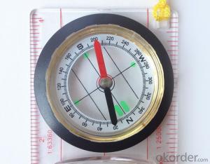

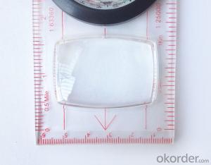


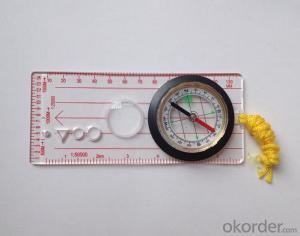
Transparant Map Scale Compass DC45-5B
- Ref Price:
-

- Loading Port:
- China Main Port
- Payment Terms:
- TT OR LC
- Min Order Qty:
- -
- Supply Capability:
- -
OKorder Service Pledge
OKorder Financial Service
You Might Also Like


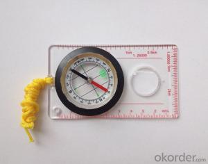
Model: DC45-5B
Name: Professional map compass, ruler compass
Product Origin: China
Supply Ability: 10,000 pcs/month
Minimum Order: 50 pcs
MOQ for OEM package: 500pcs
Product Size: 112*62*17(mm)
Features
1, professional usage: orientation, distance measuring, measuring slope, azimuth and pitching Angle measurement, drawing, a magnifying glass
2, high quality compass with neck rope, portable and rugged
3, ACRYLIC material, about 2mm thick
4, Damping Dial: to keep the stability of the pointer, more suitable for outdoor
environment.
5, Accuracy: accurate and clear, there were 360 degrees azimuth Angle, outer ring is 64-00 system, Liquid filled in the compass for reliable readings.
6, Magnifier function
- Q: Handheld GPS positioning, can be directly uploaded to the computer, and the computer has a scalable map to mark the upload point. The above system, now there are 20Such as the title, I want to achieve the final function: through the manual to a point, with a hand-held GPS locator will be recorded in the specific latitude and longitude, and sent to the network in real time, for my computer to mark these points on the map. If you can directly enter the site of some of the information, directly to the above is the bestIf you have the above equipment, please indicate the scientific name, and the specific application industry.Thanks.
- The main function of Siwei Hin GPS map tag software1 support Google online (offline) hybrid satellite maps and general maps.2 support 1-18 level map arbitrary scaling, the left mouse button drag roaming.3 support the name of the query location, you can enter the location of the location after the location of the query.
- Q: Handheld GPS navigation is what? Where to buy handheld GPS navigation, how to select GPS navigation?
- Handheld GPS is mainly for GIS data acquisition, a lot of advanced GPS with PDA function, you can load navigation software for vehicle navigationBut the handheld GPS is mainly to do some engineering design, the main area can be measured, the location, and the boundary survey. GPS can do advanced vehicle navigation can also waypoint navigation, is a coordinate input to precise navigation to this position.Handheld GPS navigation is divided into 2 kinds, one is portable GPS navigation, one is used for surveying and mapping professional GPS handheld
- Q: What is the difference between industrial GPS handset and mobile navigation
- I am a professional to do GPS, the difference between the professional handheld and mobile GPS is very understanding, here and your simple communication.1, GPS is the most important positioning accuracy and confidence. Professional handheld GPS chip used to stabilize the performance of some, the accuracy will be better, such as Garmin handheld high-end product positioning can be achieved within 3 meters, while the phone's GPS chip is different.2, both in the design and positioning of the crowd is very different. Professional GPS more focus on outdoor industry and users, the use of design idea is how to better outdoors, outdoor tourism including tourism exploration assistant very full function, and mobile phone GPS is a trend not only, what purpose.
- Q: Can a handheld navigator connect a cell phone? Thank you
- Open the phone hotspot WiFi, handheld navigator connected to this wifi.
- Q: What is the difference between professional GPS handsets and mobile navigation?
- First of all, if used outdoors, then fell, and so on are likely to water, and this thing is also very expensive, so the opportunity to have a high professional anti shock waterproof performance. You can see the Challenger I tour the next 600, three well plates.
- Q: Verify the accuracy of the GPS device to buy back, the way is to use Android under the'gps state 'software, to test the accuracy of real-time single point positioning.1 with two sets of the same Android Tablet Computer (custom machine, type of bad) in the same position for receiving, find that the accuracy is the same (software, are 1-2 meters), but the position would be poor 10 meters or more. It's in the same place.The 2 one is the Android tablet computer, a mobile phone is HTC G10, also received together in the same position, find that the accuracy is not the same as (the latter 20 meters or so), but also may be about 10 meters position difference.The accuracy of this GPS device can reach 1-2 meters, while the same location in real-time single point positioning error of 10 meters, a reasonable explanation.
- You are very normal, the tablet computer and mobile phone antenna, not inside, the highest accuracy is about 10 meters, as ordinary navigation is good enough, to achieve centimeter level accuracy by GPS single is, that is to achieve the RTK measurement, is the application of professional measurement, now RTK or by the United States GPS satellite, not the United States GPS satellite as China Beidou mobile station and the base station is in need of mutual difference calculation to achieve accurate measurement. Now the single can receive SBAS signal, single precision up to 1-2 meters, the Northeast in some places to achieve sub meter level, which is the highest single precision can reach, is also used in field investigation using professional machine.
- Q: My cell phone: HTC Hero 200Question type: Internet softwareMy work needs to locate, record, output, and input GPS coordinates. Track record measurement, coordinate transformation. So would you have a professional security software under the table, so go out with a mobile phone or a PAD, or N equipment back to survey the tired,
- Taobao to enter the online shopping, mobile phone navigator on the line, I suggest you download the Careland navigation map, or tiger map
- Q: How do I still stay in the GPS navigation, GPS monitoring of the primary idea? FiveBusiness services, thank you!Future business services
- 1 power, telecommunications, telecommunications and other network time synchronization2 accurate timing of admission3 accurate frequency of admission1 geodetic measurements of various levels2 Road and various line lofting3 underwater topographic survey4 crustal deformation measurement, dam and large building deformation monitoring5.GIS application6 construction machinery (tyre crane, bulldozer, etc.) control7 precision agricultureAt the present stage, it is mainly used for the security of vehicles and the management of personnel vehicles. With the continuous development of social economy, more and more vehicle users, GPS will gradually get wide application, on the stage of the car is enough for your service. Prospects can still be Lin Shijie GPS
- Q: Saying that we have a project in front of it is to do so, it is surprising that there are wood
- Hello friends, so, do 1:2000 topographic mapping with a handheld GPS is obviously not reality, after all, the handheld GPS precision is, however, now we are in the handheld equipment is no GPS, in fact, in the absence of the base station is a handheld GPS, receiving SBAS difference can reach sub meter level, but if a base station or receive CROS network differential signal will be RTK mobile station,
- Q: Handheld GPS each brand has what difference; different price difference in where is the positioning accuracy is different or what function is not the same?What are the differences between the measurements and the cars?
- Where the speed of the car, how many miles are open at a glance at the professional GPS locator
Send your message to us
Transparant Map Scale Compass DC45-5B
- Ref Price:
-
- Loading Port:
- China Main Port
- Payment Terms:
- TT OR LC
- Min Order Qty:
- -
- Supply Capability:
- -
OKorder Service Pledge
OKorder Financial Service
Similar products


Hot products


Hot Searches
Related keywords

