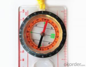


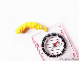
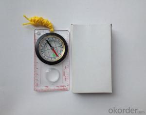
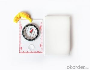
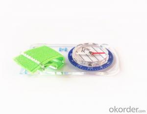
Professional Map Scale Compass with Ruler
- Ref Price:
-

- Loading Port:
- Tianjin
- Payment Terms:
- TT OR LC
- Min Order Qty:
- 50 pc
- Supply Capability:
- 10000 pc/month
OKorder Service Pledge
OKorder Financial Service
You Might Also Like


Structure of of Map Scale Compass Discription:
Model: DC45-5C
Name: Professional map compass, ruler compass
Product Origin: China
Supply Ability: 10,000 pcs/month
Minimum Order: 50 pcs
MOQ for OEM package: 500pcs
Main Features of Map Scale Compass:
1, professional usage: orientation, distance measuring, measuring slope, azimuth and pitching Angle measurement, drawing, a magnifying glass;
2, high quality compass with neck rope, portable and rugged;
3, ACRYLIC material, about 2mm thick;
4, Damping Dial: to keep the stability of the pointer, more suitable for outdoor environment;
5, Accuracy: accurate and clear, there were 360 degrees azimuth Angle, outer ring is 64-00 system, Liquid filled in the compass for reliable readings;
6, Magnifier function;
5, with ruler on compass DC45-5C;
6,for map measure and drawing;
7,one meter neck rope;
8,Liquid filled in the compass for reliable readings;
9, magnifier function;
10,night vision map compass;
11, Support OEM
Map Scale Compass Images:


Map Scale Compass Specification:
Product Size: 128*60*16(mm)
Color: OEM
FAQ of Map Scale Compass:
1,What is the warranty for this product?
3 months after receiving the device.
2,How long could we get the goods?
Within one week after payment, the product will be sent out.
3,Do you have service centers abroad?
No.The service centers are in China at present.
- Q: What factors affect the handheld GPS receive signal?
- In addition to not see the sky (such as indoor, underground, dense forest) and narrow alleys and tall buildings on both sides of the environment, there will be no impact. Many GPS has 12 receivers (antenna unit), as long as it can capture 3 satellites can be three-dimensional positioning (including height), the 2 satellites can be flat positioning.
- Q: GPS Mu meter which brand is good, handheld high-precision land area measuring instrument
- Simple operation, the screen is large, a few buttonsBoot, and then look at the star almost, to find a field, start and then click on the end of a circle, out of the number ofElectricity can alsoPrecision mody... With a special RTK or not, but what is sure to measure a circleFlat measurement of quasi accurate, biased on what is almost, it can be accepted
- Q: Is it accurate to measure highway mileage with GPS handheld
- Measuring mileage, since the unit has been upgraded to the inside, it is quite accurate oh
- Q: I am ready to go to the field to go to college, but I do not know how to buy a handheld GPS, I hope you recommend. The most important thing is easy to carry.
- Oh, if you go abroad to go to college, buy a map you can, no need to buy, if you want to buy, you have to look at what price, what configuration, entry-level like upstairs said, a few hundred dollars can buy one, but is relatively old models. No maps. If you want to have a map to your point, there are Yiliangqianliangsanqian. Recommended Garmin 60csx, Magellan explorer, Hua Cai Lu N400 can be.
- Q: Handheld GPS navigation is what? Where to buy handheld GPS navigation, how to select GPS navigation?
- Handheld GPS navigator, also known as portable navigator, but also divided into 2 kinds, one is the ordinary PND navigator, you can go to Zhongguancun, the major appliance stores to buy, and the other is the mobile navigation, GPS smart phone is installed in the GPS navigation software can be,The navigator is composed of 2 parts: hardware and navigation software. The navigator on the market is about RMB 600. The brand of Kelid navigation software is usedGPS is a portable handheld navigation navigation products, the market is now very much, most car navigation can be used, the Gps signal is still free to receive satellite signals in the United States, you only need to charge it, map to the sellers in general can be upgraded.
- Q: How to set the handheld GPS related parameters and coordinate conversion parameters throughout the country
- Collect the application area of high grade control data in GPS receiver applied earth area (such as a county) find three (or more) uniform grade (accuracy better) or GPS "B" network, the best point is around without interference of electromagnetic wave, vision, the satellite signal is strong. To the local surveying and mapping management department (such as: the local bureau of Surveying and mapping, surveying and Mapping Institute) Gauss plane coordinate copy these points of the Beijing 54 Coordinate System (x, y), the elevation of H and WGS-84 coordinates of the geodetic coordinates (B, L), the high H.
- Q: Handheld GPS charge is not into electricity what is the reason
- 3, restore the factory settings to see whether the system is.4, the battery damage, can replace the battery repair.
- Q: Handheld GPS and mobile phone GPS what is the difference?
- Handheld GPS also supports GPS compass navigation and map navigation as well as other more professional GPS applications; mobile GPS can work with fewer, more consumer grade product applications
- Q: How about the accuracy of the GPS handset?
- So the selection depends on your needs the function and budget. Haida official website mall "mobile MGIS mall".
- Q: I just bought a handheld GPS Magellan No. 1, showing the latitude and longitude coordinates, I want to set the geodetic coordinates of latitude and longitude, do not know where to set, I would like to ask you, how to set, there is a better picture shows the best, thank you so much.Magellan GPS 210 is not 2000 shy
- Latitude and longitude is the geodetic coordinates, the landlord said to be set up for the use of the projection plane Cartesian coordinates - Beijing 54 or Xi'an, the 80 plane rectangular coordinates it.1 position: [format setting unit - "[] position display format is set to User UTM Grid, and enter the relevant parameters, such as the 3 degree or 6 degree with the area with the central meridian projection, the ratio was 1, that deviation is 500000m, north-south deviation is 0.
Send your message to us
Professional Map Scale Compass with Ruler
- Ref Price:
-
- Loading Port:
- Tianjin
- Payment Terms:
- TT OR LC
- Min Order Qty:
- 50 pc
- Supply Capability:
- 10000 pc/month
OKorder Service Pledge
OKorder Financial Service
Similar products


Hot products


Hot Searches
Related keywords

