


Professional Map or Ruler CompassDC35-1B for Surveying
- Ref Price:
-

- Loading Port:
- Tianjin
- Payment Terms:
- TT OR LC
- Min Order Qty:
- 20 pc
- Supply Capability:
- 10000 pc/month
OKorder Service Pledge
OKorder Financial Service
You Might Also Like


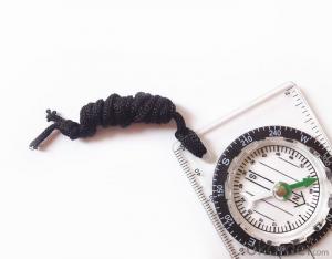
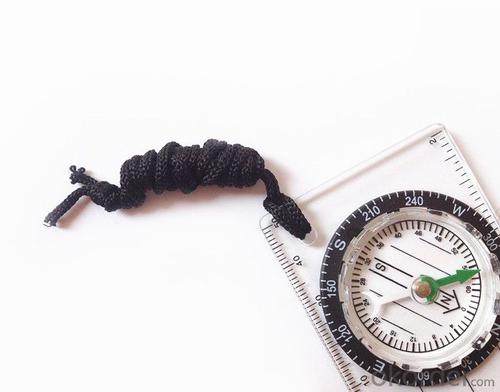
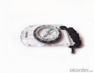
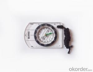
Model: DC35-1B
Name: Professional map compass, ruler compass
Product Origin: China
Supply Ability: 10,000 pcs/month
Minimum Order: 50 pcs
MOQ for OEM package: 500pcs
Product Size: 70*48*9 (mm)
Features of DC35-B
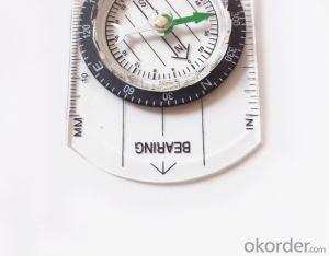
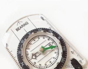
1, professional usage: orientation, distance measuring, measuring slope, azimuth and pitching Angle measurement, drawing, a magnifying glass
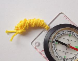
2, high quality compass with neck rope, portable and rugged
3, ACRYLIC material, about 2mm thick
4, Damping Dial: to keep the stability of the pointer, more suitable for outdoor environment.
5, Accuracy: accurate and clear, there were 360 degrees azimuth Angle, outer ring is 64-00 system, Liquid filled in the compass for reliable readings.
6, Magnifier function
5,ruler compass,
6,for map measure and drawing
7,one meter neck rope,
8,Liquid filled in the compass for reliable readings,
9, magnifier function.
- Q: I am ready to go to the field to go to college, but I do not know how to buy a handheld GPS, I hope you recommend. The most important thing is easy to carry.
- Oh, if you go abroad to go to college, buy a map you can, no need to buy, if you want to buy, you have to look at what price, what configuration, entry-level like upstairs said, a few hundred dollars can buy one, but is relatively old models. No maps. If you want to have a map to your point, there are Yiliangqianliangsanqian. Recommended Garmin 60csx, Magellan explorer, Hua Cai Lu N400 can be.
- Q: What is the difference between industrial GPS handset and mobile navigation
- 5, strong battery life, is a major feature of professional GPS, Garmin handset General of dry batteries can be used more than ten hours, while the mobile phone GPS on GPS also can use a few hours, if you open the GPS in general about 3 hours will be over.6, supporting different software. Professional GPS handheld opportunities related to the PC end of the data processing software, this software can achieve the acquisition of data processing, as well as the application of data collection. The phone GPS can only navigation, and navigation is only a small part of the GPS function.I simply say these, this is my personal summary of the difference, if you have what is not clear can exchange. Want to help you.
- Q: Can a handheld navigator connect a cell phone? Thank you
- Open the phone hotspot WiFi, handheld navigator connected to this wifi.
- Q: I bought the way k20s, this handheld GPS how
- Ordinary hand-held GPS is 3-5 meter accuracy, high accuracy can be achieved unless buy submeter ordinary user, if you can.
- Q: Handheld GPS brand rankings
- SIBAOIn the GNSS coordinate precision and attributes, "SIBAO" has a professional GPS handset, GIS i-PPP GIS, a mobile data collector, GIS, high precision GIS, high precision measurement of RTK complete product structure, to form a comprehensive solution to the spatial information industry scheme.
- Q: Mobile GPS can replace professional handheld GPS
- Ziphah measured Mu instrument, a key measurement area, the use of simple, SV-118, with high precision imported GPS module and antenna, accurate measurement, the block walk in a circle to measure the size and graphics trajectory, 550 yuan, USB charging, large capacity lithium battery, black and white screen to see the clear day for outdoor use.
- Q: What is the difference between a hand-held GPS and a car's onboard navigator
- As the first floor of a friend to answer the same, the general application of hand-held devices in land surveying, mountain climbing and other precise positioning when measuring the use of. Long standby time, three good performance. Easy to carry. A single charge can be used for a long time (depending on the machine). Although navigation, but the map is not detailed. At the same time, there is an opportunity to have latitude, latitude and other information.The car navigation is designed for users to drive out, in the field when not familiar with the road, ah, not familiar with the surrounding buildings, such as parking, hospitals, restaurants, gas stations. Used. Map details. But does not provide information such as latitude accuracy. No elevation.Look what you're doing. There is also a mobile phone navigation function.If you are purely for entertainment, then choose the phone.If you want to navigate in the car, select the vehicle navigation.If you are a very professional outdoor sports enthusiasts on the choice of handheld.
- Q: I just bought a handheld GPS Magellan No. 1, showing the latitude and longitude coordinates, I want to set the geodetic coordinates of latitude and longitude, do not know where to set, I would like to ask you, how to set, there is a better picture shows the best, thank you so much.Magellan GPS 210 is not 2000 shy
- 1 position: [format setting unit - "[] position display format is set to User UTM Grid, and enter the relevant parameters, such as the 3 degree or 6 degree with the area with the central meridian projection, the ratio was 1, that deviation is 500000m, north-south deviation is 0.2 map reference setting: [[map] - unit "benchmark is set to User, and input the DX, DY, DZ, DA, DF parameters, usually DX, DY, DZ vary from region to region, so need to know the high level control points to solve, solving methods are as follows:The handheld GPS is placed in the control point field buried pile, were measured, and then hand coordinate coordinates and the known control points of the GPS measurements obtained for the poor, can be obtained by local coordinates and elevation deviation value: DX, DY, DZ.
- Q: Handheld GPS each brand has what difference; different price difference in where is the positioning accuracy is different or what function is not the same?What are the differences between the measurements and the cars?
- Engage in measurement and what is the difference between the car I do not know, look at the car to see if the functionSMS + Mobile Internet + computer network platform! 3 ways to check the car!
- Q: What qualifications should a normal GPS locator have?
- Look at his company's business license is what's on the line, if the manufacturer has the most basic 3C proved, and some such as system certification or proof of what the explosion proof CEPREI
Send your message to us
Professional Map or Ruler CompassDC35-1B for Surveying
- Ref Price:
-
- Loading Port:
- Tianjin
- Payment Terms:
- TT OR LC
- Min Order Qty:
- 20 pc
- Supply Capability:
- 10000 pc/month
OKorder Service Pledge
OKorder Financial Service
Similar products
Hot products


Hot Searches

