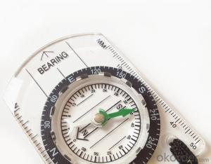


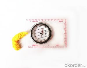
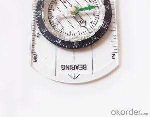
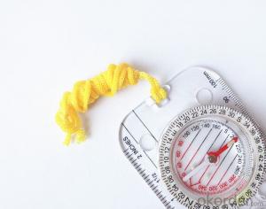
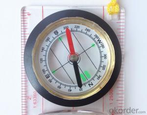
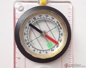
Map Scale Compass or Ruler DC35-B
- Ref Price:
-

- Loading Port:
- China Main Port
- Payment Terms:
- TT OR LC
- Min Order Qty:
- -
- Supply Capability:
- -
OKorder Service Pledge
OKorder Financial Service
You Might Also Like


Model: DC35-1B
Name: Professional map compass, ruler compass
Product Origin: China
Supply Ability: 10,000 pcs/month
Minimum Order: 50 pcs
MOQ for OEM package: 500pcs
Product Size: 70*48*9(mm)
Features
1, professional usage: orientation, distance measuring, measuring slope, azimuth and pitching Angle measurement, drawing, a magnifying glass
2, high quality compass with neck rope, portable and rugged
3, ACRYLIC material, about 2mm thick
4, Damping Dial: to keep the stability of the pointer, more suitable for outdoor
environment.
5, Accuracy: accurate and clear, there were 360 degrees azimuth Angle, outer ring is 64-00 system, Liquid filled in the compass for reliable readings.
Payment: TT or LC
- Q: Highway measurement with GPS I do not know which of the base station settings and mobile station settings I are very vague, to the instrument to build a coordinate system how to build the relevant issues to me
- If you are a GPS base station location and measurement of road staff recommend that you use the professional version of the GPS version of the great error because you said is also a way of positioning is not accurate the coordinate system should also use professional equipment and operating personnel want to help you
- Q: Handheld GPS locator measuring accuracy is about how many meters?
- The handheld machine precision is generally divided into: centimeter decimeter level, 1 meters, 2 meters, 3 meters, 5 meters;
- Q: What is the difference between professional GPS handsets and mobile navigation?
- Mobile phones are used for network navigation, no network will not work, professional GPS navigation satellite navigation,
- Q: Mountaineering to buy a professional GPS or Mountaineering Watch
- Can be downloaded in general maps, satellite maps, and even contour maps, which features far more than handheld GPS or mountain climbing watches, you can better meet the needs of mountaineering.
- Q: Professional handheld GPS GARMIN (DR) how to use
- Would like to use the function of handheld GPS purposes, the measurement of soil area, linear navigation, auxiliary fishing waypoint navigation point information, traffic data display, etc.
- Q: Handheld GPS which brand is good
- Now GPS can also do handheld measurement accuracy, precision can usually reach decimeter level, the industry there are relatively well-known Huace, professional GPS measurement instrument, high precision of handheld GPS the good.
- Q: GPS handheld function to measure it?
- If the construction survey is certainly not the case, the control measurement is possible
- Q: I just bought a handheld GPS Magellan No. 1, showing the latitude and longitude coordinates, I want to set the geodetic coordinates of latitude and longitude, do not know where to set, I would like to ask you, how to set, there is a better picture shows the best, thank you so much.Magellan GPS 210 is not 2000 shy
- 2 map reference setting: [[map] - unit "benchmark is set to User, and input the DX, DY, DZ, DA, DF parameters, usually DX, DY, DZ vary from region to region, so need to know the high level control points to solve, solving methods are as follows:The handheld GPS is placed in the control point field buried pile, were measured, and then hand coordinate coordinates and the known control points of the GPS measurements obtained for the poor, can be obtained by local coordinates and elevation deviation value: DX, DY, DZ.
- Q: Ask how to select a google satellite map into a handheld Area GPS
- If it refers to a professional portable handheld GPS, please ignore this answer.
- Q: What qualifications should a normal GPS locator have?
- You ask is handheld GPS, it is the manufacturer's qualification requirements or what. For example, business license, tax registration certificate, organization code certificate, vendor authorization, software copyright, precision test report, 3C certificate, ISO9001, industrial grade IP certificate and other relevant qualification certificates and documents
Send your message to us
Map Scale Compass or Ruler DC35-B
- Ref Price:
-
- Loading Port:
- China Main Port
- Payment Terms:
- TT OR LC
- Min Order Qty:
- -
- Supply Capability:
- -
OKorder Service Pledge
OKorder Financial Service
Similar products

Hot products


Hot Searches
Related keywords

