


Map Scale or Ruler Compass DC35F
- Ref Price:
-

- Loading Port:
- China Main Port
- Payment Terms:
- TT OR LC
- Min Order Qty:
- -
- Supply Capability:
- -
OKorder Service Pledge
OKorder Financial Service
You Might Also Like


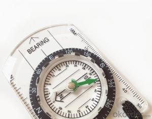
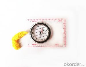
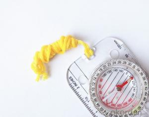
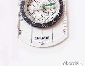
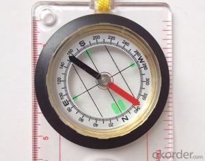
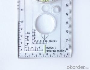
Model: DC35F
Name: Professional map compass, ruler compass
Product Origin: China
Supply Ability: 10,000 pcs/month
Minimum Order: 50 pcs
MOQ for OEM package: 500pcs
Product Size: 90*46*10 (mm)
Features
1, professional usage: orientation, distance measuring, measuring slope, azimuth and pitching Angle measurement, drawing, a magnifying glass
2, high quality compass with neck rope, portable and rugged
3, ACRYLIC material, about 2mm thick
4, Damping Dial: to keep the stability of the pointer, more suitable for outdoor
environment.
5, Accuracy: accurate and clear, there were 360 degrees azimuth Angle, outer ring is 64-00 system, Liquid filled in the compass for reliable readings.
Payment term: TT/LC
- Q: Handheld GPS positioning, can be directly uploaded to the computer, and the computer has a scalable map to mark the upload point. The above system, now there are 20Such as the title, I want to achieve the final function: through the manual to a point, with a hand-held GPS locator will be recorded in the specific latitude and longitude, and sent to the network in real time, for my computer to mark these points on the map. If you can directly enter the site of some of the information, directly to the above is the bestIf you have the above equipment, please indicate the scientific name, and the specific application industry.Thanks.
- 13 support GPS satellite positioning function, the need to connect GPS satellite positioning hardware devices (USB GPS devices or Bluetooth GPS devices; tablet PC).14 support offline map pack custom download function, you can download the map anywhere in the world.
- Q: Handheld GPS need to put the phone card?
- Hello, now the general GPS are required to put the card! Thanks
- Q: Can you buy a good handheld GPS in China? FiveTrouble master recommended several professional handheld GPS brand, in addition to handheld GPS can speed it? Thank you!!
- The main function is to use navigation as long as the navigation function can be used
- Q: What is the difference between industrial GPS handset and mobile navigation
- 3, professional handheld machine with industrial design. First of all, if used outdoors, then fell, and so on are likely to water, and this thing is also very expensive, so the opportunity to have a high professional anti shock waterproof performance.4, different screen design. If you look carefully, you can see in the outdoor light, mobile phone can not see the contents of the screen, while the professional handset is not the same, can see clearly in bright light, does not affect the work of foreign trade operations.
- Q: What is the difference between the phone's GPS and professional handheld GPS features and differences?
- With more professional and more accurate positioning but are generally used dry batteries or rechargeable batteries not built-in rechargeable battery that is because handheld GPS users are mostly investigation or walk tourists convenient in use and emphasizes there is screen are generally of low power consumption for general color screen can only convey longitude and altitude mobile phone GPS is just a subsidiary function loading car navigation map
- Q: I am a handheld GPS precision is low, how to use to be able to improve certain accuracy.
- If you can join the CORS network, the accuracy of decimeter to centimeter level.
- Q: Handheld GPS brand rankings
- SIBAOIn the GNSS coordinate precision and attributes, "SIBAO" has a professional GPS handset, GIS i-PPP GIS, a mobile data collector, GIS, high precision GIS, high precision measurement of RTK complete product structure, to form a comprehensive solution to the spatial information industry scheme.
- Q: Jia Ming etre20 handheld GPS good
- The new generation of the eTrex series is the first generation of user level receivers that can track both GPS and GLONASS satellites. GLONASS global navigation satellite system developed by Russian Federation, fully put into use. When using the GLONASS satellite, the average time for the receiver to lock the target is about 20% faster than GPS. And, when using both GPS and GLONASS, the receiver has the ability to lock more than 24 satellites as compared to GPS alone.
- Q: Professional handheld GPS GARMIN (DR) how to use
- Handheld GPS purposes, the measurement of soil area, linear navigation, auxiliary fishing waypoint navigation point information, traffic data display, such as the use of functional machines should be used manual
- Q: I just bought a handheld GPS Magellan No. 1, showing the latitude and longitude coordinates, I want to set the geodetic coordinates of latitude and longitude, do not know where to set, I would like to ask you, how to set, there is a better picture shows the best, thank you so much.Magellan GPS 210 is not 2000 shy
- Latitude and longitude is the geodetic coordinates, the landlord said to be set up for the use of the projection plane Cartesian coordinates - Beijing 54 or Xi'an, the 80 plane rectangular coordinates it.1 position: [format setting unit - "[] position display format is set to User UTM Grid, and enter the relevant parameters, such as the 3 degree or 6 degree with the area with the central meridian projection, the ratio was 1, that deviation is 500000m, north-south deviation is 0.
Send your message to us
Map Scale or Ruler Compass DC35F
- Ref Price:
-
- Loading Port:
- China Main Port
- Payment Terms:
- TT OR LC
- Min Order Qty:
- -
- Supply Capability:
- -
OKorder Service Pledge
OKorder Financial Service
Similar products
Hot products


Hot Searches
Related keywords

