


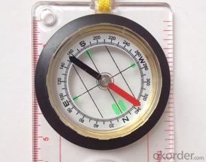
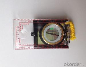
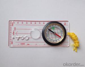
Map Scale Compass DC45-5D with Ruler
- Ref Price:
-

- Loading Port:
- China Main Port
- Payment Terms:
- TT OR LC
- Min Order Qty:
- -
- Supply Capability:
- -
OKorder Service Pledge
OKorder Financial Service
You Might Also Like


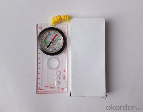
Model: DC45-5D
Name: Professional map compass, ruler compass
Product Origin: China
Supply Ability: 10,000 pcs/month
Minimum Order: 50 pcs
MOQ for OEM package: 500pcs
Product Size: 140*61*17(mm)
Features
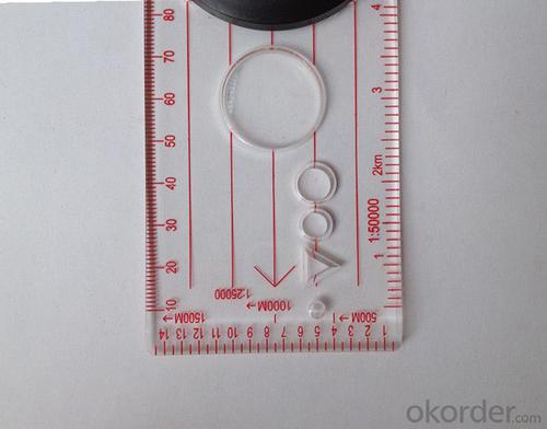
1, professional usage: orientation, distance measuring, measuring slope, azimuth and pitching Angle measurement, drawing, a magnifying glass
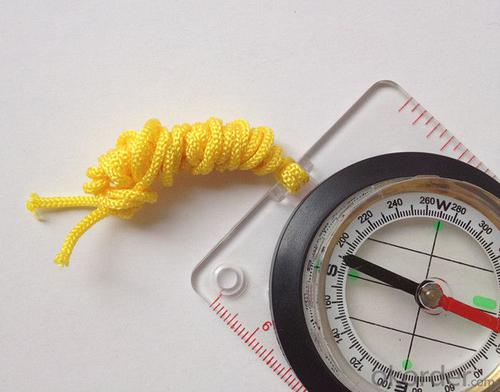
2, high quality compass with neck rope, portable and rugged
3, ACRYLIC material, about 2mm thick
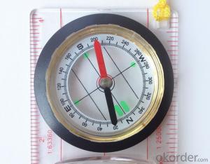
4, Damping Dial: to keep the stability of the pointer, more suitable for outdoor
environment.
5, Accuracy: accurate and clear, there were 360 degrees azimuth Angle, outer ring is 64-00 system, Liquid filled in the compass for reliable readings.
Payment: TT or LC
- Q: GPS Mu meter which brand is good, handheld high-precision land area measuring instrument
- A German born mu can also recommend a good precision measuring instrument.Simple operation, the screen is large, a few buttonsBoot, and then look at the star almost, to find a field, start and then click on the end of a circle, out of the number ofElectricity can alsoPrecision mody... With a special RTK or not, but what is sure to measure a circleFlat measurement of quasi accurate, biased on what is almost, it can be accepted
- Q: Is it accurate to measure highway mileage with GPS handheld
- Can only say that the handheld GPS measurement of highway mileage can be a reference, if you want to measure the accuracy or sub meter level or professional measuring tools better
- Q: I am ready to go to the field to go to college, but I do not know how to buy a handheld GPS, I hope you recommend. The most important thing is easy to carry.
- At present, the formal channels genuine licensed not so cheap, some refurbished machines may have. The cheapest machines now have about 900-1000!
- Q: Handheld GPS navigation is what? Where to buy handheld GPS navigation, how to select GPS navigation?
- Handheld GPS is mainly for GIS data acquisition, a lot of advanced GPS with PDA function, you can load navigation software for vehicle navigationBut the handheld GPS is mainly to do some engineering design, the main area can be measured, the location, and the boundary survey. GPS can do advanced vehicle navigation can also waypoint navigation, is a coordinate input to precise navigation to this position.Handheld GPS navigation is divided into 2 kinds, one is portable GPS navigation, one is used for surveying and mapping professional GPS handheld
- Q: GPS handheld function to measure it?
- If the construction survey is certainly not the case, the control measurement is possible
- Q: Handheld GPS charge is not into electricity what is the reason
- 3, restore the factory settings to see whether the system is.4, the battery damage, can replace the battery repair.
- Q: Handheld GPS and mobile phone GPS what is the difference?
- Different: antenna size, function, accuracy, protection level, and has been different in the application layer (handheld GPS support GPS compass navigation and map navigation and other more professional GPS applications);
- Q: In addition to the parameters, that is the problem of the machine, what method can reduce the error of these two machines to a minimum. Because, at the same time to find a coordinate. The gap is too big.
- GPS was in error with 10 meters, with the star search results, related to the environment, if the precision is high, as long as the use of handheld GPS submeter or handheld RTK
- Q: I just bought a handheld GPS Magellan No. 1, showing the latitude and longitude coordinates, I want to set the geodetic coordinates of latitude and longitude, do not know where to set, I would like to ask you, how to set, there is a better picture shows the best, thank you so much.Magellan GPS 210 is not 2000 shy
- Latitude and longitude is the geodetic coordinates, the landlord said to be set up for the use of the projection plane Cartesian coordinates - Beijing 54 or Xi'an, the 80 plane rectangular coordinates it.1 position: [format setting unit - "[] position display format is set to User UTM Grid, and enter the relevant parameters, such as the 3 degree or 6 degree with the area with the central meridian projection, the ratio was 1, that deviation is 500000m, north-south deviation is 0.
- Q: Handheld GPS purchaseHandheld GPS navigator!Is mainly used for tourism, I said is not a mobile phone, is a more professional handheld GPS navigator for travel outside! Handheld GPS navigator can voice navigation?
- Many outdoor enthusiasts are used to this, hiking, cycling and other applications are relatively wide, is an American brand, Mr Zelen back to U.S. Army GPS, and as Ma Ying-Jeou ring when riding on the handlebars also put a good 60CSX. the two brands in the nature, the price is more expensive, are in more than 2000, but the best is to the store to buy. If only for tourism, generally hundreds of pieces of GPS will be enough, go to computer city to see, must be sold, or go to your city in the outdoor store to see.
Send your message to us
Map Scale Compass DC45-5D with Ruler
- Ref Price:
-
- Loading Port:
- China Main Port
- Payment Terms:
- TT OR LC
- Min Order Qty:
- -
- Supply Capability:
- -
OKorder Service Pledge
OKorder Financial Service
Similar products

Hot products


Hot Searches
Related keywords

