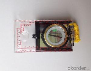


Map Scale Compass DC45-6A with Ruler
- Ref Price:
-

- Loading Port:
- China Main Port
- Payment Terms:
- TT OR LC
- Min Order Qty:
- -
- Supply Capability:
- -
OKorder Service Pledge
OKorder Financial Service
You Might Also Like


Model: DC45-6A
Name: Professional map compass, ruler compass
Product Origin: China
Supply Ability: 10,000 pcs/month
Minimum Order: 50 pcs
MOQ for OEM package: 500pcs
Product Size: 122*64*22 (mm)
Features
1, professional usage: orientation, distance measuring, measuring slope, azimuth and pitching Angle measurement, drawing, a magnifying glass
2, high quality compass with neck rope, portable and rugged
3, ACRYLIC material, about 2mm thick
4, Damping Dial: to keep the stability of the pointer, more suitable for outdoor
environment.
5, Accuracy: accurate and clear, there were 360 degrees azimuth Angle, outer ring is 64-00 system, Liquid filled in the compass for reliable readings.
Payment term: TT/ LC
- Q:My friend is in use, the difference is not big, professional handset (smart or Magellan bulky, but 3 case), but the price is expensive, but can not call and map is very rotten, endurance of 10 hours (dry battery) the mobile phone also has all the time. Know friends say, I mainly in the suburbs! Thanks
- Three, the map of the differenceIn terms of the difference between the two maps is relatively large, most of the hand-held machine using contour map, the city is only as a secondary auxiliary. The mobile map is just the opposite, very detailed description of the city streets.Refer toThere is no road for GPS routing calculation. Popular said, handheld GPS to do is to draw a straight line to the destination, to determine their own inflection point. Handheld GPS will tell you to the destination: distance, course, yaw distance and other information (a lot of parameters, you can choose to display). In addition, handheld GPS also has to add a new landmark, through the software to draw their own waypoints, the average position of the measurement function, and even can measure the height and temperature, highlighting the degree of professionalism of its application.Cell phone navigation is very different from the former. GPS will be in accordance with the routing algorithm to calculate the nearest path, the premise is to have a detailed street map. GPS will tell you the right to turn right at the intersection. Mobile GPS can also search the starting point near the point of interest information, and can calculate the fastest path to reach the land.
- Q:Handheld GPS navigation is what? Where to buy handheld GPS navigation, how to select GPS navigation?
- Handheld GPS navigator, also known as portable navigator, but also divided into 2 kinds, one is the ordinary PND navigator, you can go to Zhongguancun, the major appliance stores to buy, and the other is the mobile navigation, GPS smart phone is installed in the GPS navigation software can be,The navigator is composed of 2 parts: hardware and navigation software. The navigator on the market is about RMB 600. The brand of Kelid navigation software is usedGPS is a portable handheld navigation navigation products, the market is now very much, most car navigation can be used, the Gps signal is still free to receive satellite signals in the United States, you only need to charge it, map to the sellers in general can be upgraded.
- Q:What do you need to test for GPS?
- 6 antenna type to give you a good positioning, GPS receiver requires at least 3 ~ 5 satellites are visible. If you are in a canyon or on both sides of the street, or in the dense jungle, you may not be able to contact with enough satellites, so that you can not locate or only two-dimensional coordinates. Also, if you're in a building inside, you may not be able to update your location, some GPS receivers have a separate antenna can be attached to the windshield, or built-in active antenna, or an external active antenna can be placed on the roof, the receiver which helps you get more satellite signals the. 7 other indicators to buy GPS equipment, according to the needs and use of the environment, size, weight, waterproof, shockproof, dustproof performance, high temperature resistance, power consumption and other indicators should be taken into account.
- Q:Handheld GPS, the measurement of arable land, fixed point and circle test, which is more accurate,
- So for you to measure the area, some of the 3cm point error surrounded by the graphics area and some millimeter level point error surrounded by the graphics area is not much difference.
- Q:GPS Mu meter which brand is good, handheld high-precision land area measuring instrument
- A German born mu can also recommend a good precision measuring instrument.
- Q:I bought the way k20s, this handheld GPS how
- Choi way handheld GPS feel that you can also be in the last year, the Zhengzhou Bureau of Surveying and mapping seems to be called the wide Han instrument that home to buy, so there is no problem with it, the price is not expensive.
- Q:How to use the handheld GPS whole watershed investigation
- The critical value is an object from a physical state to another physical state, a physical quantity to meet the conditions, which is equivalent to the stagnation point in Mathematics
- Q:Can a handheld navigator connect a cell phone? Thank you
- Mobile navigator can downloadOther purchases can not beNow basically use the phoneEasy update and operation
- Q:The navigation module it is "selph" three generation? Another one I mainly use it to measure the land area, easy to use, the error is not big?I want to buy Magellan 500 do not know whether it is good to use
- Can only use professional GPS measuring instrument! Magellan and SIBAO!
- Q:Fuxin coordinates with the mapping of the seven parameters are what ah there is no professional knowledge to tell my brother I need to fill the gps... Thanks.
- XYZ offset, XYZ twist, 6, plus a scaling factor.Seven parameters have to be calculated, or from the local surveying and mapping departments to.
1. Manufacturer Overview |
|
|---|---|
| Location | |
| Year Established | |
| Annual Output Value | |
| Main Markets | |
| Company Certifications | |
2. Manufacturer Certificates |
|
|---|---|
| a) Certification Name | |
| Range | |
| Reference | |
| Validity Period | |
3. Manufacturer Capability |
|
|---|---|
| a)Trade Capacity | |
| Nearest Port | |
| Export Percentage | |
| No.of Employees in Trade Department | |
| Language Spoken: | |
| b)Factory Information | |
| Factory Size: | |
| No. of Production Lines | |
| Contract Manufacturing | |
| Product Price Range | |
Send your message to us
Map Scale Compass DC45-6A with Ruler
- Ref Price:
-
- Loading Port:
- China Main Port
- Payment Terms:
- TT OR LC
- Min Order Qty:
- -
- Supply Capability:
- -
OKorder Service Pledge
OKorder Financial Service
Similar products


New products


Hot products


Related keywords

