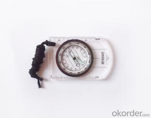

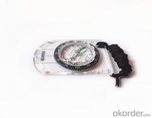
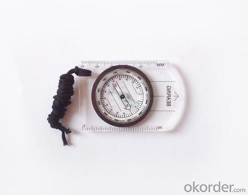
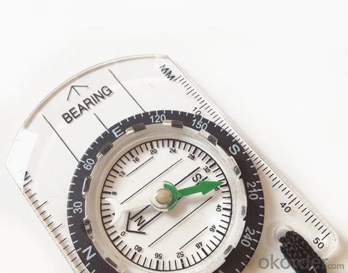

Transparant Map Compass DC35-1B
- Ref Price:
-

- Loading Port:
- China Main Port
- Payment Terms:
- TT OR LC
- Min Order Qty:
- -
- Supply Capability:
- -
OKorder Service Pledge
OKorder Financial Service
You Might Also Like


Model: DC35-1B
Name: Professional map compass, ruler compass
Product Origin: China
Supply Ability: 10,000 pcs/month
Minimum Order: 50 pcs
MOQ for OEM package: 500pcs
Product Size: 70*48*9 (mm)
Features
1, professional usage: orientation, distance measuring, measuring slope, azimuth and pitching Angle measurement, drawing, a magnifying glass
2, high quality compass with neck rope, portable and rugged
3, ACRYLIC material, about 2mm thick
4, Damping Dial: to keep the stability of the pointer, more suitable for outdoor
environment.
5, Accuracy: accurate and clear, there were 360 degrees azimuth Angle, outer ring is 64-00 system, Liquid filled in the compass for reliable readings.
6, Magnifier function
- Q: Handheld GPS how to achieve decimeter
- Hello A GPS is not up to the requirements of the class, if no one can buy that expensive submeter GPS, currently on the market with the best precision is GPS, is Derek GARMIN this year a new eTrex 10, 20 and 30, the three can be reached within 3 meters accuracy, you can look at
- Q: What is the difference between professional GPS handsets and mobile navigation?
- GPS is the most important positioning accuracy. Professional handheld machine with industrial design. First of all, if used outdoors, then fell, and so on are likely to water, and this thing is also very expensive, so the opportunity to have a high professional anti shock waterproof performance.
- Q: I am a handheld GPS precision is low, how to use to be able to improve certain accuracy.
- If you can join the CORS network, the accuracy of decimeter to centimeter level.
- Q: Jia Ming etre20 handheld GPS good
- Jia Ming eTrex 20 has a microSD card slot and 1.7GB built-in memory space eTrex 20 allows you to store more user acquisition information, in addition to the map expansion slot, you can load the map of the global area of Garmin.
- Q: Verify the accuracy of the GPS device to buy back, the way is to use Android under the'gps state 'software, to test the accuracy of real-time single point positioning.1 with two sets of the same Android Tablet Computer (custom machine, type of bad) in the same position for receiving, find that the accuracy is the same (software, are 1-2 meters), but the position would be poor 10 meters or more. It's in the same place.The 2 one is the Android tablet computer, a mobile phone is HTC G10, also received together in the same position, find that the accuracy is not the same as (the latter 20 meters or so), but also may be about 10 meters position difference.The accuracy of this GPS device can reach 1-2 meters, while the same location in real-time single point positioning error of 10 meters, a reasonable explanation.
- 10 meters.To the world in 2013 a total of four global satellite navigation system, in addition to the United States has been in the mature GPS system and commercial operation, the Beidou system, China the European Galileo system, the Russian GLONASS system are still under construction. "The Galileo satellite navigation project" was first conceived by the 30 satellite GPS network to compete with the United States, the beginning of the design proposed in 2008 formally put into operation, and later postponed to 2014, the entire system is only 4 satellites in orbit (as of 2012), in fact it is mainly used to further verify the relevant design and the working system of the system design, after the official start of Galileo satellite will launch. Formal networking satellites are being prepared. China satellite navigation system management office senior engineer Yang Qiangwen introduction, to 2012, the "system" in orbit satellites are also only verify satellite.
- Q: GPS handheld function to measure it?
- It depends on what kind of GPS handset. Some machines have this feature.
- Q: Saying that we have a project in front of it is to do so, it is surprising that there are wood
- It is really unexpected, basically not, the accuracy is not enough!
- Q: How about the accuracy of the GPS handset?
- So the selection depends on your needs the function and budget. Haida official website mall "mobile MGIS mall".
- Q: The navigation module it is "selph" three generation? Another one I mainly use it to measure the land area, easy to use, the error is not big?I want to buy Magellan 500 do not know whether it is good to use
- Can only use professional GPS measuring instrument! Magellan and SIBAO!
- Q: Handheld GPS purchaseHandheld GPS navigator!Is mainly used for tourism, I said is not a mobile phone, is a more professional handheld GPS navigator for travel outside! Handheld GPS navigator can voice navigation?
- Many outdoor enthusiasts are used to this, hiking, cycling and other applications are relatively wide, is an American brand, Mr Zelen back to U.S. Army GPS, and as Ma Ying-Jeou ring when riding on the handlebars also put a good 60CSX. the two brands in the nature, the price is more expensive, are in more than 2000, but the best is to the store to buy. If only for tourism, generally hundreds of pieces of GPS will be enough, go to computer city to see, must be sold, or go to your city in the outdoor store to see.
Send your message to us
Transparant Map Compass DC35-1B
- Ref Price:
-
- Loading Port:
- China Main Port
- Payment Terms:
- TT OR LC
- Min Order Qty:
- -
- Supply Capability:
- -
OKorder Service Pledge
OKorder Financial Service
Similar products


Hot products


Hot Searches

