
Rugged handheld GIS K7
- Ref Price:
-

- Loading Port:
- China Main Port
- Payment Terms:
- TT OR LC
- Min Order Qty:
- -
- Supply Capability:
- -
OKorder Service Pledge
OKorder Financial Service
You Might Also Like


PJK 7
Detailed Description
1.Lemon coaxial external antenna connector
2.High sensitivity integrated antenna
3.USB: Mini B/slave
PJK 7
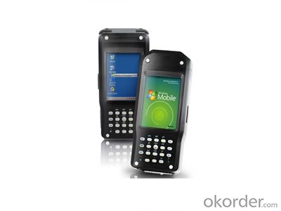
PJK 7 is a bran-new rugged handheld GPS/GIS equipment. It provides a complete set of all necessary features required of a mapping device for anyone who needs productive data collection and efficient asset management in the field. Through post-processing, the positions of every GIS feature you collect can be better than sub-meter-level accuracy.
The innovative design integrates all the communication components offering an all-in-one robust solution to the user. The PJK 7 offers a unique design with various crackajack capabilities. It includes internal and removable battery, internal memory, specific kits per application and full compatibility with various software solutions from the third part.
The PJK 7 comes with Microsoft Windows Mobile 6, a color touch-screen, and has Bluetooth for wireless connectivity. This handy feature-rich GPS includes an integrated 3-megapixel camera, an embedded speaker and microphone to enrich the collected data with pictures and voice notes.
High performance fully rugged handheld for real-time communication in any harsh conditions:
l MIL-STD 810G and IP65 Compliance
l 128M RAM/128M ROM
l Microsoft Windows CE 6.0
l 400MHz Mobile Computing Platform
l Portrait 3.5″QVGA(240×320),
Transflective sunlight readable display
Pressure sensitive touchscreen
l SDIO / SDHC Card Slot for Flexible
Expansion and Storage
l Field Swappable 1900mAh Li-Ion,
Battery with Long Battery Life
(12Hours without GPRS)
l Embedded High Sensitivity GPS
l Embedded Bluetooth 2.0 module
l Embedded 802.11b/g WLAN module
l Receiver and 3M Pixels Auto-focus Camera
l 2.5G/3.5G WWAN (HSDPA / WCDMA /EDGE / GPRS / GSM)(Option)
l Embedded RFID module (Option)
l Lemon coaxial external antenna connector
Package Contents
The PTK 7 handheld device package contains:
− 1 PJK 7 handheld device
− 1 USB data communication cable
− 1 Rechargeable battery pack
− 2 Styluses
− 1 Power adaptor
− 1 CD-ROM Software Development Kit and User’s manual
− 1 Warranty card
Optional Accessories
- External GPS survey antenna
- Hand Strap
- Carrying case
- Charging on cradle
System
- Microsoft Windows CE 6.0 Professional
- Processor:400 MHz
- 128MB DRAM and 128MB Flash ROM
- Display 64K Color TFT LCD with 320 x 240 pixel resolution, with LED backlight and touch screen, Advanced sunlight readable display.
GPS Characteristics
20 parallel channels
Integrated SBAS(WAAS,EGNOS,MSAS)
L1 C/A code and carrier
Update rate: 1Hz
Protocol: NMEA 0183 v 3.0
RTCM SC-104 version 2.3(9.2 &1.2)
High sensitivity integrated antenna
Accuracy Specifications
Real-Time Performance (RMS)
- 80cm with VRS/CORS corrections
- 1m with one base corrections
Post-processing Performance (RMS)
- 40 cm
Static Survey Performance (RMS)
(With need external survey antenna)
- Horizontal:0.005m + 1ppm
- Vertical:0.01m +2ppm
Mechanical Features
- Dimensions (L x W x H): 17.5 x 8.2 x 4.1 cm
- Weight: 450 g (incl. battery)
Power Characteristics
- Battery type: 7.4V lithium-ion,1900mAh
- Removable, Rechargeable battery
- Battery life:
Over 12 hours run-time with GPS
Over 6 hours run-time with GPS and wireless communication
- External power port for extended operation time
Environmental Features
- Operating temperature: -20° to + 50 °C
- Storage temperature: -30° to +70 °C
- Humidity: 90% non condensing for temperatures < 40°C
- Protection: IP65
- ESD protection: 8 KV contact discharge, 15 KV air discharge
- Drop resistance: 1.2 m / 4 ft
Interface
- Integrated Bluetooth/802.11b/g WLAN wireless technology
- Lemon coaxial external antenna connector
- USB: Mini B/slave
- Integrated 2.5G/3.5G data-link (option)
- 3-megapixel digital camera
- Port for communication Dock
Option
- 2.5G/3.5G Wireless module
- RFID Module
Stand Software
- GISMAPPING Software
Receiver Description
Front Panel
- Q: What factors affect the handheld GPS receive signal?
- In addition to not see the sky (such as indoor, underground, dense forest) and narrow alleys and tall buildings on both sides of the environment, there will be no impact. Many GPS has 12 receivers (antenna unit), as long as it can capture 3 satellites can be three-dimensional positioning (including height), the 2 satellites can be flat positioning.
- Q: I would like to ask the GPS handset and GPS receiver (Surveying and mapping qualification application needs) is there a difference? If yes, what is the difference?
- This is the case, GPS handheld refers to a thin hand, while the GPS receiver refers to the RTK host, equivalent to the base station in our industry said. The general application of Surveying and mapping qualifications are required for this application, referred to as RTK (1+1) set, level, theodolite, total station, walkie talkie, technical personnel.... And so on, are essential equipment.
- Q: Handheld GPS how to achieve decimeter
- Hello A GPS is not up to the requirements of the class, if no one can buy that expensive submeter GPS, currently on the market with the best precision is GPS, is Derek GARMIN this year a new eTrex 10, 20 and 30, the three can be reached within 3 meters accuracy, you can look at
- Q: Is it accurate to measure highway mileage with GPS handheld
- Can only say that the handheld GPS measurement of highway mileage can be a reference, if you want to measure the accuracy or sub meter level or professional measuring tools better
- Q: What is the difference between professional GPS handsets and mobile navigation?
- Mobile phones are used for network navigation, no network will not work, professional GPS navigation satellite navigation,
- Q: I am a handheld GPS precision is low, how to use to be able to improve certain accuracy.
- Look at the maximum accuracy of GPSIf the difference accuracy can reach 1cm you can connect CORS single base station and other network RTK way to achieve the corresponding accuracy
- Q: In addition to the parameters, that is the problem of the machine, what method can reduce the error of these two machines to a minimum. Because, at the same time to find a coordinate. The gap is too big.
- GPS was in error with 10 meters, with the star search results, related to the environment, if the precision is high, as long as the use of handheld GPS submeter or handheld RTK
- Q: How to hand GPS eTrex H data to the computer
- You have a data cable, the computer installed on the MapSource software, connect the computer and handheld GPS can transfer data!!!"Shaanxi skmax navigation information Limited" GARMIN proxy (GARMIN official website can be found), contact (Xiao Hou) the hope can help to you, if you do not understand what we see on the Internet, may at any time, contact us
- Q: Handheld GPS purchaseHandheld GPS navigator!Is mainly used for tourism, I said is not a mobile phone, is a more professional handheld GPS navigator for travel outside! Handheld GPS navigator can voice navigation?
- Many outdoor enthusiasts are used to this, hiking, cycling and other applications are relatively wide, is an American brand, Mr Zelen back to U.S. Army GPS, and as Ma Ying-Jeou ring when riding on the handlebars also put a good 60CSX. the two brands in the nature, the price is more expensive, are in more than 2000, but the best is to the store to buy. If only for tourism, generally hundreds of pieces of GPS will be enough, go to computer city to see, must be sold, or go to your city in the outdoor store to see.
- Q: Handheld GPS, the measurement of arable land, fixed point and circle test, which is more accurate,
- If the area is measured, are almost. However, if the measurement point is only the case, the dynamic GPS is now the general error can be guaranteed within 3cm, the total station can be guaranteed to the millimeter.
Send your message to us
Rugged handheld GIS K7
- Ref Price:
-
- Loading Port:
- China Main Port
- Payment Terms:
- TT OR LC
- Min Order Qty:
- -
- Supply Capability:
- -
OKorder Service Pledge
OKorder Financial Service
Similar products
Hot products


Hot Searches
Related keywords

