


Professional Ruler Mini-Compass DC35F for Surveying
- Ref Price:
-

- Loading Port:
- Tianjin
- Payment Terms:
- TT OR LC
- Min Order Qty:
- 20 pc
- Supply Capability:
- 10000 pc/month
OKorder Service Pledge
OKorder Financial Service
You Might Also Like


Model: DC35F
Name: Professional map compass, ruler compass
Product Origin: China
Supply Ability: 10,000 pcs/month
Minimum Order: 20 pcs
MOQ for OEM package: 500pcs
Product Size: 128*60*16 (mm)
Features of DC35F
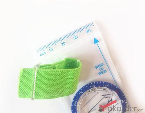
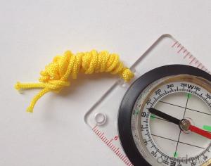
1, professional usage: orientation, distance measuring, measuring slope, azimuth and pitching Angle measurement, drawing, a magnifying glass
2, high quality compass with neck rope, portable and rugged
3, ACRYLIC material, about 2mm thick
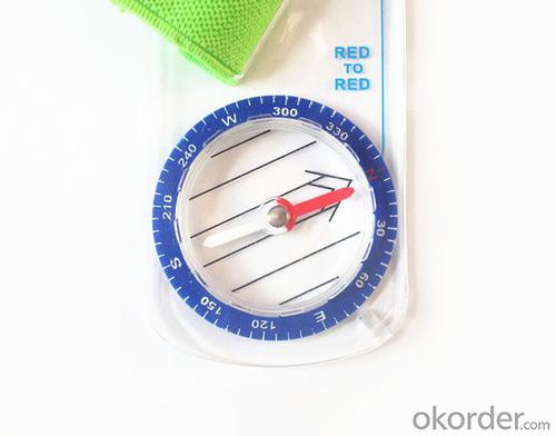
4, Damping Dial: to keep the stability of the pointer, more suitable for outdoor environment.
5, Accuracy: accurate and clear, there were 360 degrees azimuth Angle, outer ring is 64-00 system, Liquid filled in the compass for reliable readings.
6, Magnifier function
5,ruler compass,
6,for map measure and drawing
7,one meter neck rope,
8,Liquid filled in the compass for reliable readings,
9, magnifier function.
10,night vision map compass
- Q: Handheld GPS buried in the soil there is a signal
- It depends on how deep you buried the darker the GPS signal, and must ensure that the GPS antenna upward, the above can not be covered with metal objects
- Q: I am ready to go to the field to go to college, but I do not know how to buy a handheld GPS, I hope you recommend. The most important thing is easy to carry.
- Younger brother, buy a smart phone, ranging from several hundred dollars to several thousand dollars, as long as the GPS module on the line, understand it?I'm not talking about it, as long as the smart phone with GPS module, you can use when GPS, can be used to drive, you can certainly use a walk. Even if there is no GPS die fast, with a cell phone signal can be positioned, but not too accurate. Hundreds of meters.In addition, you go to college, do not use smart phones, students are not afraid of jokes? Buy a Android system on the machine line. Cheap on a few hundred dollars.You say you take a hand-held machine, and then take a cell phone to go out, trouble is not trouble?
- Q: What is the difference between professional GPS handsets and mobile navigation?
- First of all, if used outdoors, then fell, and so on are likely to water, and this thing is also very expensive, so the opportunity to have a high professional anti shock waterproof performance. You can see the Challenger I tour the next 600, three well plates.
- Q: Mountaineering to buy a professional GPS or Mountaineering Watch
- Now the mobile phone is the essential tool, mobile phone has GPS, can pre download ordinary maps, satellite maps, and contour map, its function is far more than a handheld GPS or hiking watches, can better meet the needs of the mountain.
- Q: Hand held GPS coordinate conversion method
- By the 84 coordinates to Beijing 54 Coordinate. A collection of application area of high grade control data in GPS receiver applied earth area (such as a county) find three (or more) uniform grade (accuracy better) or GPS "B" dot, point the best is around without interference of electromagnetic wave, vision, satellite signal. To the local surveying and mapping management department (such as: the local bureau of Surveying and mapping, surveying and Mapping Institute) Gauss plane coordinate copy these points of the Beijing 54 Coordinate System (x, y), the elevation of H and WGS-84 coordinates of the geodetic coordinates (B, L), the high H.
- Q: Handheld GPS brand rankings
- SIBAOIn the GNSS coordinate precision and attributes, "SIBAO" has a professional GPS handset, GIS i-PPP GIS, a mobile data collector, GIS, high precision GIS, high precision measurement of RTK complete product structure, to form a comprehensive solution to the spatial information industry scheme.
- Q: What do you need to test for GPS?
- As a high-tech product, GPS has a very complex technical parameters. However, as people's living standards improved rapidly, more and more ordinary people began to pay attention to the positioning and navigation tools originated from the military. Because the convenience it brings is unprecedented. In order to let everyone out of all the technical parameters of GPS receiver, no longer confused at the time of purchase, the author selected six of the most important technical indicators, one by one to explain to you. 1 parallel channels on the market most of the GPS receiver is a 8 channel, 12 channel, the 16 channel, which allows them to continuously track the information of each satellite. Some GPS devices only have 2 to 5 parallel channel receiving satellite signals, because the average of 8 satellites are visible, which means that the GPS receiver must visit each of the satellites in order to obtain information about each satellite. All of our products are in Shenzhen channel 16 channel, multi-channel parallel GPS receiver, including the advantages of rapid cold start and initialization of satellite information, but also in the forest area can have a better reception. General 12 channel receiver does not require an external antenna, unless you are in a bad environment conditions such as closed space, such as the cabin, the car. 2 the sensitivity of the GPS satellite signal to the ground has been very weak, as well as ground wireless communication clutter interference. The lowest traceable signal strength of the GPS receiver determines how much useful signal is received. A GPS receiver with a lower minimum tracking signal strength has a higher sensitivity, and can receive more available satellites under bad conditions
- Q: How about the accuracy of the GPS handset?
- So the selection depends on your needs the function and budget. Haida official website mall "mobile MGIS mall".
- Q: Magellan GPS handheld why so many people choose not to say that the map is not good
- Each brand has its own unique, if you only care about a map, then you think of the handheld too one-sided
- Q: Handheld GPS each brand has what difference; different price difference in where is the positioning accuracy is different or what function is not the same?What are the differences between the measurements and the cars?
- Where the speed of the car, how many miles are open at a glance at the professional GPS locator
Send your message to us
Professional Ruler Mini-Compass DC35F for Surveying
- Ref Price:
-
- Loading Port:
- Tianjin
- Payment Terms:
- TT OR LC
- Min Order Qty:
- 20 pc
- Supply Capability:
- 10000 pc/month
OKorder Service Pledge
OKorder Financial Service
Similar products


Hot products


Hot Searches

