
High-end GIS K8
- Ref Price:
-

- Loading Port:
- China Main Port
- Payment Terms:
- TT OR LC
- Min Order Qty:
- -
- Supply Capability:
- -
OKorder Service Pledge
OKorder Financial Service
You Might Also Like


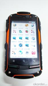
PJK 8 is a GPS data collection devices based with smart tablet Android operating system; 3.5 Cunban through the half- screen which is visible under bright light , high-resolution , ultra-thin , rugged design, easy to complete the wild variety of environments data collection ; built-in 3G data acquisition allows interaction within and outside the industry that has quickly realized .
Product Features
1, the basic functions
Operating system : Android 4.0, massive applications at your fingertips
Processor : 1GHZ processor speed
Memory capacity RAM: 512MB ROM: 4G
Memory card : MicroSD (TF) card , up to 32GB
2 , data collection
Data acquisition system with professional mobile GIS data collection , field mapping, waypoint storage coordinates to calculate the length , angle , and other areas of field measurement data , with a key two-coordinate conversion function .
3, GPS features
Differential : Support SBAS (MSAS, WAAS, EGNOS)
Real-time differential :1-3m
Single precision :3-5m
4 , communication performance
Built-in GSM and WCDMA communications , high-speed data transfer easy , can support voice calls
Bluetooth : 2.1 + EDR
WIFI: Support 802.11 Wireless LAN
USB: 2.0
5, the extended application
5 million pixel camera , 300,000 auto-focus camera ,
Video capture,
Built-in microphone supports voice attribute collection
Built-in electronic compass ,
Under no circumstances can indicate GPS direction , support multiple GPS intelligent navigation software
Support for emergency lighting and portrait and landscape screen automatically switches .
1, the physical properties of
Size : 125 * 65.5 * 20.5MM
Weight : 204G
Working temperature: -20 to 65 degrees
Storage temperature : -40 ℃ ~ 70 ℃
Humidity : 100 % non-condensing
Waterproof and dustproof : IP67
Anti- fall drop : Anti 1.5 meters free fall
Roll : Roll 1000 0.5 m height
Rugged and lightweight : GE Industrial grade high fire-retardant materials plus lightweight structure designed to allow field operations no longer be a burden.
2 , the display characteristics
Display: 3.5 -inch
Type: Multi -point capacitive touch screen
Brightness: anti-glare display, highlight
Resolution : 320 × 480
3, the power characteristics
Battery : 2000mAH Lithium Battery
Working hours : 10 hours of continuous work
4 ,Quality Certification
Product complies with EU CE, ROSH standards, China 's national quasi- GB 21288-2007 requirements
- Q: Handheld GPS how to achieve decimeter
- Hello A GPS is not up to the requirements of the class, if no one can buy that expensive submeter GPS, currently on the market with the best precision is GPS, is Derek GARMIN this year a new eTrex 10, 20 and 30, the three can be reached within 3 meters accuracy, you can look at
- Q: I am ready to go to the field to go to college, but I do not know how to buy a handheld GPS, I hope you recommend. The most important thing is easy to carry.
- Younger brother, buy a smart phone, ranging from several hundred dollars to several thousand dollars, as long as the GPS module on the line, understand it?I'm not talking about it, as long as the smart phone with GPS module, you can use when GPS, can be used to drive, you can certainly use a walk. Even if there is no GPS die fast, with a cell phone signal can be positioned, but not too accurate. Hundreds of meters.In addition, you go to college, do not use smart phones, students are not afraid of jokes? Buy a Android system on the machine line. Cheap on a few hundred dollars.You say you take a hand-held machine, and then take a cell phone to go out, trouble is not trouble?
- Q: What is the difference between industrial GPS handset and mobile navigation
- I am a professional to do GPS, the difference between the professional handheld and mobile GPS is very understanding, here and your simple communication.1, GPS is the most important positioning accuracy and confidence. Professional handheld GPS chip used to stabilize the performance of some, the accuracy will be better, such as Garmin handheld high-end product positioning can be achieved within 3 meters, while the phone's GPS chip is different.2, both in the design and positioning of the crowd is very different. Professional GPS more focus on outdoor industry and users, the use of design idea is how to better outdoors, outdoor tourism including tourism exploration assistant very full function, and mobile phone GPS is a trend not only, what purpose.
- Q: Want to buy handheld GPS in Hongkong, I would like to ask what brand is better, the specific model? Where to buy? How much is the price? In the mainland can be used? More questions, thank you!
- Specific model depends on what you are doing, almost two thousand or three thousand of the words can be. Good point is four thousand to six thousand.
- Q: Jia Ming etre20 handheld GPS good
- Jia Ming eTrex 20 has an enhanced 2.2 inch screen, a color rendering effect of 65 thousand TFT, a readable display in the sun. Durable waterproof, but also upgraded the interface to retain the existing hardness and toughness, to withstand dust, dirt, moisture and water erosion, these are not the legendary navigator opponent.
- Q: Verify the accuracy of the GPS device to buy back, the way is to use Android under the'gps state 'software, to test the accuracy of real-time single point positioning.1 with two sets of the same Android Tablet Computer (custom machine, type of bad) in the same position for receiving, find that the accuracy is the same (software, are 1-2 meters), but the position would be poor 10 meters or more. It's in the same place.The 2 one is the Android tablet computer, a mobile phone is HTC G10, also received together in the same position, find that the accuracy is not the same as (the latter 20 meters or so), but also may be about 10 meters position difference.The accuracy of this GPS device can reach 1-2 meters, while the same location in real-time single point positioning error of 10 meters, a reasonable explanation.
- You are very normal, the tablet computer and mobile phone antenna, not inside, the highest accuracy is about 10 meters, as ordinary navigation is good enough, to achieve centimeter level accuracy by GPS single is, that is to achieve the RTK measurement, is the application of professional measurement, now RTK or by the United States GPS satellite, not the United States GPS satellite as China Beidou mobile station and the base station is in need of mutual difference calculation to achieve accurate measurement. Now the single can receive SBAS signal, single precision up to 1-2 meters, the Northeast in some places to achieve sub meter level, which is the highest single precision can reach, is also used in field investigation using professional machine.
- Q: GPS handheld function to measure it?
- If the construction survey is certainly not the case, the control measurement is possible
- Q: Handheld GPS charge is not into electricity what is the reason
- Reason analysis:1, battery damage. 2, system failure. 3, charger reasons or bad contact.
- Q: Handheld GPS each brand has what difference; different price difference in where is the positioning accuracy is different or what function is not the same?What are the differences between the measurements and the cars?
- Engage in measurement and what is the difference between the car I do not know, look at the car to see if the functionSMS + Mobile Internet + computer network platform! 3 ways to check the car!
- Q: What is the difference between professional navigation and professional GPS navigator
- 3 map software is accurate, you can identify the road on the viaduct, and you can tip up and down viaduct."This should be no problem currently on the market of the navigation software is mainly three: Skywalker, Kai Lide, cityonmap. Three navigation software has its own advantages and disadvantages. I personally feel that the person with Skywalker more, some car navigation systems (non open operating system) OEM software with Kay more than cityonmap map Skywalker is better but the interface is not good.4 mobile phone PDA load or other independent GPS devices can be.
Send your message to us
High-end GIS K8
- Ref Price:
-
- Loading Port:
- China Main Port
- Payment Terms:
- TT OR LC
- Min Order Qty:
- -
- Supply Capability:
- -
OKorder Service Pledge
OKorder Financial Service
Similar products

Hot products


Hot Searches
Related keywords

