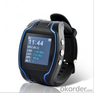


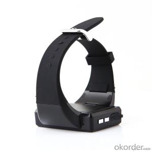
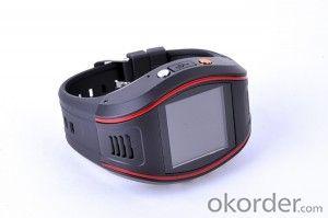
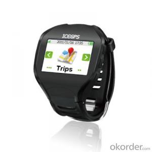
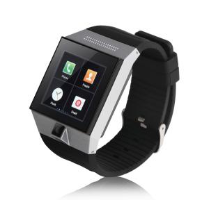
Wrist Watch GPS Tracking Device for Kids with SOS Web
- Ref Price:
-

- Loading Port:
- China main port
- Payment Terms:
- TT or LC
- Min Order Qty:
- 1000 set
- Supply Capability:
- 100000 set/month
OKorder Service Pledge
OKorder Financial Service
You Might Also Like


Wrist watch gps tracking device for kids with sos web based tracking website
Wrist Watch Features
1. Check the location on the map by smart phone with the Google map's URL.
2. Track by mobile SMS to get the GPS coordinates.
3. Track on gps tracking platform.
4. With LCD display to show the time & GPS coordinates information.
5. Two-way talking function, with 2 shortcut buttons for fast calling out 3phone numbers.
6. Geo-fence alert.
7. SOS button to call for help in case of emergency.

Wrist Watch Parameter
GSM Frequency | 850/900/1800/1900MHZ |
| Gps chip | G-TOP |
| GPRS | class12,TCP/IP build in GSM MODULE |
| GPS Sensitivity | -159dbm |
| GPS Accuracy | 10m(2D RM) |
| GSM Accuracy | 10-50m |
| Speed Accuracy | 0.1m/s |
Cold Status | -38s |
| Warm Status | -32s |
| Hot starus | -2s |
| MaximumAltitude | 18000m |
| Highest Speed | 515m/s |
| Acceleration 0f Gravity | <4g |
| Size | 65*45.5*18(mm) |
| Weight | 0.38kg |
| Working Tememperature | -20--+ 70°C |
| Humidity | 20% --80%RH |
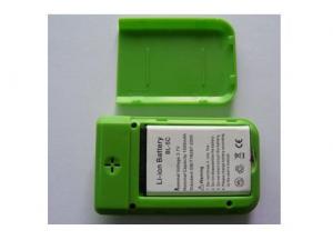
| Battery | 500MAH |
| Standby time | 20h/5min GPRS Mode 48h/SMS Mode |
| Screen Size | 1.51inch |
FAQ:
Q1: What is your minimum order quantity?
A:The minimum order quantity is 1000 ,but it is negotiable.
Q2:What is your payment terms?
A: T/T,Western Union,Paypal,L/C...
Q3:What is your delivery time?
A:Production time usually costs 2-20 days.
Waiting to cooperate with you!
- Q: I heard that the function is the most complete, you can listen to it? Many function
- You want more, GPS is not listening, but you can locate.
- Q: How to register GPS locator?
- I do not have to register, there are two software, 15
- Q: Millet 3 how to close the GPS positioning system
- 1, pull out the notification bar from the screen;2, select the switch to find the GPS icon, if it is lit, click on the GPS icon turned gray, turn off.
- Q: The vehicle must renew it in the seller GPS.
- GPS vehicle positioning system, under normal circumstances is a must in your query platform operators renewals. If you have a locator communication protocol, you can also find a platform operator, by binding GPS locator, then you can re select operators.Penghu and location service platform is a kind of application software for vehicle, intelligent mobile phone and other mobile smart devices, to provide real-time positioning, personnel and vehicle trajectory, attendance system, security and other related services. Main functions: real-time positioning (personnel positioning, mobile phone positioning, vehicle positioning, regional alarm), trajectory query (map track) query, attendance statistics (remote attendance, customer call records, attendance, attendance table position table), SMS function, map labeling (any place marking) etc..For the government and enterprises to implement personnel (mobile phone), real-time positioning and vehicle trajectory query, attendance management and other services, to understand business progress for enterprise managers timely and accurately, through lean management, improve employee performance and profit.
- Q: Electric vehicle GPS locator about how much money, do you know?
- The rabbit is very good GPS, real-time GPS positioning tracking;
- Q: How much is the platform cost per month after the installation of GPS positioning system
- Love to stare at the first year of free platform fee free gift, second years from 60/ years, including the life of the platform with the platform after the platform do not have to pay fees. Love staring at the metal body, external dual antenna, strong signal. Mobile app check car, WeChat car is very convenient.
- Q: Motorcycle GPS locator which brand is good
- Motorcycle GPS locator is simple, compact and compact, strong anti-interference, Baidu look at it, there are a lot of good GPS locator brand oh
- Q: What are the four global positioning systems?
- China's Beidou satellite navigation system and the United States, GPS, Russia's Glonass, the European Galileo (Galileo) and known as the world's four largest satellite positioning system.
- Q: After the phone off the GPS service, but also be tracked?
- If the mobile phone when the hand closed the GPS service, can be traced to? The answer is yes, but also needs some conditions.The principle is: one of the GPS mobile phone only realize the function of positioning technology, but also through the communication base station, Wi-Fi hotspot to mobile phone positioning. The localization technique is used most in all kinds of mobile phone positioning software is GPS positioning technology and base station positioning.
- Q: Wrong track GPS locator equipment, track points about inconsistent with the actual position?
- Do you not see before the product platform, Liaoyuan star GPS positioning system, the trajectory is clear, the accuracy of 5-10 meters.
Send your message to us
Wrist Watch GPS Tracking Device for Kids with SOS Web
- Ref Price:
-
- Loading Port:
- China main port
- Payment Terms:
- TT or LC
- Min Order Qty:
- 1000 set
- Supply Capability:
- 100000 set/month
OKorder Service Pledge
OKorder Financial Service
Similar products


Hot products
Hot Searches
Related keywords

