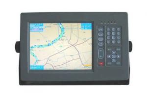

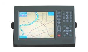
Marine GPS Navigator 1010
- Ref Price:
-

- Loading Port:
- China Main Port
- Payment Terms:
- TT or LC
- Min Order Qty:
- 1 Set/Sets set
- Supply Capability:
- 1000 Set/Sets Per Year set/month
OKorder Service Pledge
OKorder Financial Service
You Might Also Like


|
Physical & Performance | |
|
Unit dimensions, WxHxD |
5.9" x 6.1" x 2.4" (15.0 x 15.5 x 6.1 cm) |
|
Display size, WxH |
3.0" x 4.0", 5.0" diagonal (7.6 x 10.2 cm, 12.7 cm diagonal) |
|
Display resolution, WxH |
480 x 640 pixels |
|
Display type |
VGA display |
|
Weight |
1.7 lb (0.8 kg) |
|
Battery |
none |
|
Battery life |
none |
|
Waterproof |
Yes (IPX7) |
|
High-sensitivity receiver |
Yes |
|
Antenna |
internal |
|
NMEA input/output |
NMEA 0183 compatible and NMEA 2000® certified |
|
Power consumption |
0.6A at 12V; 0.3A at 24V 0.8A at 12V; 0.4A at 24V (with sonar)
|
|
Maps & Memory | |
|
Basemap |
Yes |
|
Preloaded maps |
No |
|
Ability to add maps |
Yes |
|
Built-in memory |
none (cannot load maps to internal memory) |
|
Accepts data cards |
dual microSD™ card slots |
|
Waypoints/favorites/locations |
5,000 |
|
Routes |
100 |
|
Track log |
50,000 points; 50 saved tracks |
|
Features & Benefits | |
|
Touchscreen |
Yes |
|
Supports AIS (tracks target ships' position) |
Yes |
|
Supports DSC (displays position data from DSC capable VHF radio) |
Yes |
|
Audible alarms |
Yes |
|
Tide tables |
Yes |
|
Hunt/fish calendar |
No |
|
Sun and moon information |
Yes |
|
Automatic routing (turn by turn routing on roads) |
No |
|
Headphone jack/audio line-out |
No |
|
Audio/video input/output |
No |
|
Portable |
No |
|
Automotive/motorcycle-friendly |
No |
- Q: How to use navigation
- Navigation: enter the game - open the HolyNavi.exe- role - choose your character will be able to useAssistant: navigation assistant - the game started by Home- - their own settings can also be used
- Q: Who can give a world map of the great navigation era OL
- Give you an e-mail address to send a GPS software, he has spent half a year. security
- Q: Three necessary conditions of ancient ocean navigation is: ______ navigation, use the rudder steering, the effective use of ______.
- Three necessary conditions of ancient ocean navigation is: use the rudder steering, effective use of wind with compass navigation,.The answer is: compass, wind
- Q: Hello everyone!I would like to ask the current navigation C/A code GPS receiver can achieve the positioning accuracy is how much?98 years ago, the accuracy is 15m, the new literature is not seen.Thank you very much
- In general, the direct positioning accuracy is between 7-15 meters. Do the difference can be done even centimeters.
- Q: I just want to go somewhere, I want to have a route between the destination and the destination. ,
- On the chart, different steering points (waypoint) are determined from the port of origin to the port of destination, depending on your draft and the depth of water required to be retained and the situation of the water. And these points can be entered in the GPS.
- Q: It's like the captain's studioSome M me
- I've been playing for a long time!I never met!
- Q: Do not automatically navigation skills to eat fruit, as long as you are a GPS can show my position
- So that the use of plug-ins, it is recommended low-key action
- Q: GPS can you measure the course? Which is more accurate than the compass course?GPS can also measure the flow rate and flow? The log is how to measure the velocity and direction? Which precise? Whichever shall prevail?GPS how to measure the air pressure difference?GPS how to measure the magnetic difference? How to measure the day no time? How do you get it? Accurate?
- GPS measurement of a lot of Tianbao SPS series, support for dual antenna, a positioning, a directional. The flow rate and the flow direction are strictly impossible to measure, but can be loaded into other devices. I don't know what you mean, I don't know. It should mean the magnetic declination, cannot be obtained by GPS specific value can be calculated by the relative position of multiple, eliminate the influence of magnetic declination.
- Q: OL, what is the meaning of the removal of the entire team in holy navigation? What is the use?
- For example, I have the ability to disperse, you and I team, you make a rat on the ship, I can help you solve
- Q: Mainland China has no big navigation era OL ah
- Now a lot of a lot of web games are big navigation OL when the key words, one into the hey! However, the sea can still be a big picture of the sea, but can still be an addiction. For example, joint interaction, Sina has this game is good.
1. Manufacturer Overview
| Location | Jiangsu,China |
| Year Established | 2008 |
| Annual Output Value | US$1 Million - US$2.5 Million |
| Main Markets | Mid East;Eastern Europe;South America |
| Company Certifications |
2. Manufacturer Certificates
| a) Certification Name | |
| Range | |
| Reference | |
| Validity Period |
3. Manufacturer Capability
| a) Trade Capacity | |
| Nearest Port | Shanghai |
| Export Percentage | 81% - 90% |
| No.of Employees in Trade Department | 150 |
| Language Spoken: | English, Chinese |
| b) Factory Information | |
| Factory Size: | Above 20,000 square meters |
| No. of Production Lines | 20 |
| Contract Manufacturing | OEM Service Offered;Design Service Offered |
| Product Price Range | Average |
Send your message to us
Marine GPS Navigator 1010
- Ref Price:
-
- Loading Port:
- China Main Port
- Payment Terms:
- TT or LC
- Min Order Qty:
- 1 Set/Sets set
- Supply Capability:
- 1000 Set/Sets Per Year set/month
OKorder Service Pledge
OKorder Financial Service
Similar products
Hot products
Hot Searches
Related keywords

