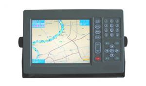
Marine GPS Navigator 1008
- Ref Price:
-

- Loading Port:
- China Main Port
- Payment Terms:
- TT or LC
- Min Order Qty:
- 1 Set/Sets set
- Supply Capability:
- 1000 Set/Sets Per Year set/month
OKorder Service Pledge
OKorder Financial Service
You Might Also Like
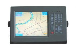


Physical & Performance of GPS Navigator | |
Unit dimensions, WxHxD | 5.9" x 6.1" x 2.4" (15.0 x 15.5 x 6.1 cm) |
Display size, WxH | 3.0" x 4.0", 5.0" diagonal (7.6 x 10.2 cm, 12.7 cm diagonal) |
Display resolution, WxH | 480 x 640 pixels |
Display type | VGA display |
Weight | 1.7 lb (0.8 kg) |
Battery | none |
Battery life | none |
Waterproof | Yes (IPX7) |
High-sensitivity receiver | Yes |
Antenna | internal |
NMEA input/output | NMEA 0183 compatible and NMEA 2000® certified |
Power consumption | 0.6A at 12V; 0.3A at 24V
0.8A at 12V; 0.4A at 24V (with sonar) |
Maps & Memory of GPS Navigator | |
Basemap | Yes |
Preloaded maps | No |
Ability to add maps | Yes |
Built-in memory | none (cannot load maps to internal memory) |
Accepts data cards | dual microSD™ card slots |
Waypoints/favorites/locations | 5,000 |
Routes | 100 |
Track log | 50,000 points; 50 saved tracks |
Features & Benefits of GPS Navigator | |
Touchscreen | No |
Supports AIS (tracks target ships' position) | No |
Supports DSC (displays position data from DSC capable VHF radio) | No |
Audible alarms | Yes |
Tide tables | Yes |
Hunt/fish calendar | No |
Sun and moon information | Yes |
Automatic routing (turn by turn routing on roads) | No |
Headphone jack/audio line-out | No |
Audio/video input/output | No |
Portable | No |
Automotive/motorcycle-friendly | No |
- Q: also do navigation aviation related products, which is the key?
- The Garmin product positioning is, outdoor communications products, so it is difficult to say which is the key, take the following data contrast:Unit sales accounted for in the fourth quarter of 2016Car navigation mobile device 11.43%Aviation equipment 5.11%Fitness equipment 24.12%Navigation equipment 27.05%Outdoor equipment 11.29%Which car navigation and mobile terminal device is the overall share of the decline, the rest are in a state of steady rise.
- Q: How is a ship guided by a compass in navigation
- I also do the workbook, fuck, no one answer, do so swollen
- Q: How to use navigation
- Navigation: enter the game - open the HolyNavi.exe- role - choose your character will be able to useAssistant: navigation assistant - the game started by Home- - their own settings can also be used
- Q: How about GPS navigation, okay?
- Other car navigation, aviation and navigation, in recent years, the rapid development of the GPS is very popular with their outdoor sports watch bracelet.
- Q: Three necessary conditions of ancient ocean navigation is: ______ navigation, use the rudder steering, the effective use of ______.
- Because the earth is a huge magnet, geomagnetic north pole in the geographic South Pole near the geomagnetic South Pole in the geographic north pole, it is the earth magnet to make the role of small needle points to the north and south direction.
- Q: What is the main way for submarines to navigate underwater?1 radar2 satellite system3.GPRS4 inertial system
- The submarine navigation instrument is more, but mainly rely on the inertial navigation system. Inertial navigation system is the only one capable of launching nuclear submarine navigation and weapons to provide all the necessary data of the equipment, compared with other navigation methods, besides the advantage of high precision, high degree of automation, the most prominent is completely independent, it depending on the inertial components of the navigation, and any other reference materials (such as shore objects and stars and sun, radio waves, etc.) do not have any relationship, so without interference and destruction, concealment and good performance, in the military application has a very important significance.With the help of the inertial navigation system belongs to the electronic navigation instruments of power. The substance of the work, which is arranged on a platform of the accelerometer measured submarine motion acceleration, then through computer to acceleration after a integral speed range obtained by two points, and then calculate the submarine's longitude and latitude, and roll angle, speed, distance and direction of navigation parameters. Submarine launched ballistic missiles, must know the exact location, status and speed to the launch time of submarines, ballistic calculation precision, the ultimate guarantee of fall point accuracy.
- Q: (listed as the following 4 points) due to the literature in this area is not easy to find.. So God help you a lot of trouble ~ if you have the relevant Chinese and English (the best English), then sent to The more, the better..1 development process: divided into several stages, major events of the year, turning point, the extent of the current application, advantages and disadvantages2 technical issues: key technologies, difficulties and limitations3 outlook4 GPS in the field of enlightenment to us
- 1.7 other applicationsThe navigation technologies used in this paper are as follows: GPS (GNSS); sonar technology; INS; navigation chart; radio navigation technology; image matching technology; other technologies.The communication technology mainly includes: FM and TV subcarrier unidirectional data / voice communication; beacon network bidirectional data communication; trunking communication; cellular communication; digital land mobile communication; satellite mobile communication; traffic trail communication etc..The first 5 kinds of communication technologies are mainly used in coastal, inland river and lake area.
- Q: Navigation and longitude latitude
- The direction of the East and West, which is gradually shortened from the equator to the north and south polesThe equator to the Antarctic latitude, equatorial North latitude.
- Q: OL, what is the meaning of the removal of the entire team in holy navigation? What is the use?
- The rest of the team is the vessel abnormality occurs can also use props skills such as B ship A ship launch command (automatic argument premise A ship skill props)
- Q: Can the GPS satellite monitoring system be used in navigation?
- Of course, the navigation ability of the GPS system is no matter where, as long as it covers the range, and have accepted the device can be used on the ground for vehicles and other navigation sections, also in the sea for the ship navigation
1. Manufacturer Overview
| Location | Jiangsu,China |
| Year Established | 2008 |
| Annual Output Value | US$1 Million - US$2.5 Million |
| Main Markets | Mid East;Eastern Europe;South America |
| Company Certifications |
2. Manufacturer Certificates
| a) Certification Name | |
| Range | |
| Reference | |
| Validity Period |
3. Manufacturer Capability
| a) Trade Capacity | |
| Nearest Port | Shanghai |
| Export Percentage | 81% - 90% |
| No.of Employees in Trade Department | 150 |
| Language Spoken: | English, Chinese |
| b) Factory Information | |
| Factory Size: | Above 20,000 square meters |
| No. of Production Lines | 20 |
| Contract Manufacturing | OEM Service Offered;Design Service Offered |
| Product Price Range | Average |
Send your message to us
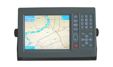
Marine GPS Navigator 1008
- Ref Price:
-
- Loading Port:
- China Main Port
- Payment Terms:
- TT or LC
- Min Order Qty:
- 1 Set/Sets set
- Supply Capability:
- 1000 Set/Sets Per Year set/month
OKorder Service Pledge
OKorder Financial Service
Similar products
Hot Searches
Related keywords

