
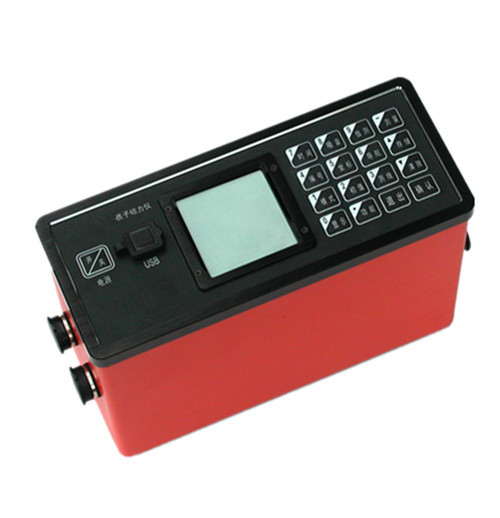
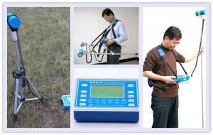
WCZ-3 Proton Magnetometer
- Ref Price:
-

- Loading Port:
- China Main Port
- Payment Terms:
- TT OR LC
- Min Order Qty:
- -
- Supply Capability:
- -
OKorder Service Pledge
OKorder Financial Service
You Might Also Like


WCZ-3 proton magnetometer is the latestall-purposed digital proton magnetometer with dual 32-bit single-chiptechnology, fastest measurement speed, strongest gradient tolerance, and theenhanced GPS navigation function.
It apply for moving total fieldmeasurement, horizontal gradient measurement, vertical gradient measurement andstation measurement with ±1nT measurement accuracy, and up to 0.1nT resolution.
Application:
• Mineral survey, such asiron ore, lead-zinc ore, copper ore
• Mineral prospecting asmineral ore depth, orientation, continuity
and ore shape, size and scale
• Oil, natural gas survey,related geological structure
• General survey, localsurvey and geological mapping
• Base station for aerial ormarine magnetic survey
• Fault detection
• Archaeology
• Hydrogeology
• Engineering survey, suchas pipe prospecting
• Monitoring earthquakeauspice, volcano and other environmental disasters.
• Small ferromagneticmaterial prospecting
Main Features:
• Integrated design——mainframe designed with built-in GPS antenna, GPS module and lithium batterymodule making operation easier and reliable.
• High-speed measurement——it only needs 2s from start measurement to display data
• Auto and manual turning support
• Strong gradient tolerance——it can gain measuring data under the environment with a higher gradient.Although the gradient is larger than 8000nT/m, the operator can gain theestimated magnetic value by the proprietary function of “ESTIMATE”, for laterdata procession and regional assessment.
• Comprehensive data quality assessment——through monitoring the signal duration,signal amplitude and noise amplitude, give a reference for
operator to do data quality assessmentand field work adjustment.
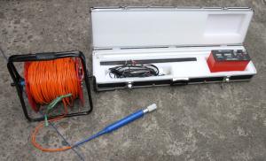
• Can do total field measurement, horizontalgradient measurement, vertical gradient measurement and station measurement(gradient measurement need one more set of probe and dedicated probe holder,station measurement needs dedicated probe tripod).
• Optional gradient measurementmode——instrument supports not only traditional single-channel dual-probeseparate gradient measurement, but also dual-channeldual-probe simultaneous high-speed gradient measurement. Among them, dual-channel simultaneousmeasurement mode decreases half time compare to traditional single-channelseparate measurement mode, but need to add dedicated measurement channel board (optional).
• Complete GPS Navigation function——support import coordinates of each points on survey line as text file,also can preset coordinate of endpoint of survey line, the instrument cancalculate the coordinates automatically. Support above 80 kinds of coordinateformat, such as latitude and longitude, UTM, etc. It can display locationinformation and deviation of set points location at anytime.
• More accuracyquartz clock synchronize——GPS time transmitting
function calibrate the built-inprecision clock automatically to ensure the
clock of station measurement and movingmeasurement are synchronized.
• Massdata storage——storeeach survey points with measurement result, survey point coordinate, elevation,time and temperature, etc, can store 2million survey points data.
• Storedata as U disk format——store data via USB port, the instrument can be recognized as U disk bycomputer automatically, copy and cut data file just as U disk, the operation isvery easy.
• Auto display magnetic curve.
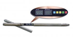
• Menu-style keyboard, make the operationeasier and more convenient.
• Backlight LCD, fitted for nightsurvey.
• Easy and portable, the whole system isdesigned with sensor-antenna pack frame and thus can be operated by oneperson.
• Standard software isavailable for plotting contour map, profile, track diagram and even correctingdiurnal variation.
Technicalspecifications:
Channels | 1. channel(standard configuration, for separate gradient measurement) 2. channels(optional, for simultaneous gradient measurement) |
Measuring range | 20,000 nT ~ 100,000nT |
Accuracy | ±0.5nt (fine mode) , ±1nT (standard mode) |
Resolution | 0.05(fine mode) and 0.1nT (standard mode) |
Gradient permitted | ≤8,000nT/m |
Measuring speed | ≤3s reading (fine mode), ≤ 2s/reading (standard mode) |
Station measuring interval | 2~60s, optional |
Data stored | large than 2 billion points readings, with power-off protection |
GPS Positioning accuracy | higher than 2.5m CEP |
LCD display | 160×160, with backlight |
Keyboard input | 16 keys |
Port | USB standard serial port |
Power source | Rechargeable lithium battery (for 4000 times reading), external power supply optional (12V) |
Console dimension | 206mm × 85mm ×155mm |
Weight | 1.5Kg (including battery) |
Sensor size | φ75mm×155mm |
Sensor weight | 0.8 Kg |
Working temperature | -10 ℃~+50 ℃ |
Send your message to us
WCZ-3 Proton Magnetometer
- Ref Price:
-
- Loading Port:
- China Main Port
- Payment Terms:
- TT OR LC
- Min Order Qty:
- -
- Supply Capability:
- -
OKorder Service Pledge
OKorder Financial Service
Similar products
Hot products

Hot Searches
Related keywords

