


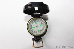
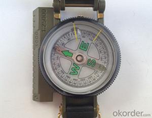
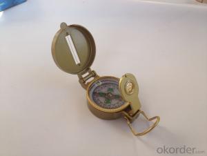
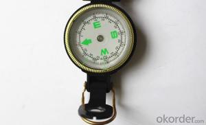
Army or Military Compass DC45-A
- Ref Price:
-

- Loading Port:
- Tianjin
- Payment Terms:
- TT OR LC
- Min Order Qty:
- -
- Supply Capability:
- 5000 pc/month
OKorder Service Pledge
OKorder Financial Service
You Might Also Like


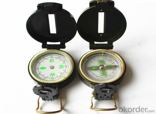
Model: DC45-A1
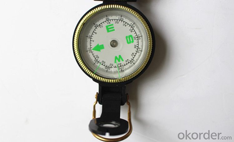
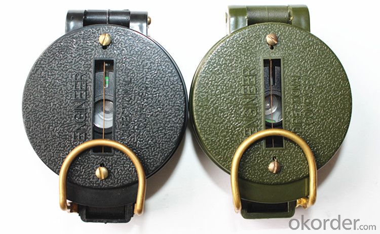
Name: outdoor hiking or military compass and army compass, metal compass and marching compass in aluminium material
Product Origin: China
Supply Ability: 40,000 pcs/month
Minimum Order: 100 pcs
MOQ for OEM package: 500pcs
Wight: 53g
Product Size: 76*53*30 (mm)
Color: Army Green, Military green, Black
Material: Aluminum alloy
Features:
1)Can easily folds to fit in your pocket
2) The compass is highly accurate and features a liquid-damped compass card with a luminous dial that can easily be read at night, and a standard bezel with two yellow lines at 45 degree angles
3) The compass card has both the standard 0 - 360 degree scale, as well as the 0 - 64Mil scale (one yard at 1,000 yards)
4) The bezel rotates with detents every 3 degrees so you can change the heading reference a known amount without looking at the compass
5) The front sight has a magnifier to simultaneously view the magnetic heading when taking a sight
6) A second magnifier assists in reading the magnetic heading when direct viewing from above
7) When unfolded flat, the marching compass has a straight edge with a standard 1:25,000 or 1:50000 map scale
8) This compass is protected by a durable cast metal case painted dark black with military drab
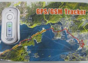
- Q: I bought a real carpenter car GPS locator, and then I clearly insert the boot how to display is not enabled? Which God knows?
- On the market most of the GPS locator is 100 meters range, if the location to be more precise, is an GPS car loan location is within 30 meters, the location is also according to the platform, if you use the GPS locator platform is not stable, it is in vain. The platform, GPS positioning platform three six five IOT is very stable.
- Q: GPS locator on the flow of electric vehicles and mobile phone traffic can be shared
- Can not, the locator card and cell phone card is not the same, and then, only 30M traffic locator
- Q: How to turn off the car GPS tracking locator
- 1, on the platform to see the show expired, is your service period, the need to pay the platform fee
- Q: Just burglary was not a very expensive mountain bike, intends to buy a car with GPS, please recommend a few easy to use micro GSP locator, a treasure on the more complex, a few requirements:As small as possible, the mountain car is not easy to hide.Life as long as possible, 35 days a charge that is not convenient to use.Don't seven hundred or eight hundred ha, cheap point.
- For several years without contact, you still choose it, you want to save electricity, then you can not set the background to the general requirements of the boot, and then re boot the boot location.
- Q: Car GPS locator buy what brand good
- Each of the different types of locator itself is also a lot of different features, of course, the most important is inseparable from the real-time positioning and history track view;Locator is good, you have to buy GPS locator can meet your needs, if you can meet your needs, it is good, can not meet your needs that is useless;
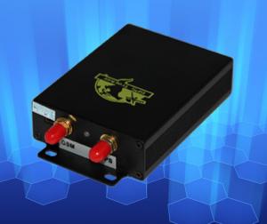
- Q: My friend bought a car to install satellite positioning system I am interested in my friend explained that I would like to ask who knows the professional interpretation (product principle) who knows who
- It can be seen that the role of the GPS navigation satellite system is to continuously transmit navigation messages. However, because the user receives the clock and satellite machine using a carrier clock may not always synchronized, so in addition to the 3D coordinates of X, y, Z users, but also the introduction of a t that is the time difference between the satellite and the receiver as unknown, and then use the 4 equation the 4 unknowns out. So if you want to know the location of the receiver, at least to receive the signal of 4 satellites.The GPS receiver may receive for accurate timing information to nanosecond time; for forecasting ephemeris in the next few months which the approximate location of the satellite; used to calculate the required positioning satellite coordinates of the broadcast ephemeris, the accuracy of several meters to tens of meters (each satellite is different at any time change) and GPS system information; such as satellite status.The GPS receiver can get the distance from the satellite to the receiver by the measurement of the code, because it contains the receiver satellite clock error and atmospheric propagation error, it is called the pseudo distance. The pseudo distance measured by the 0A code is called the pseudo distance of the UA code, the precision is about 20 meters, the pseudo distance measured by the P code is called the pseudo distance of the P code, and the precision is about 2 meters.
- Q: European GPS locator customer service phone
- My device IMEI number forgot? Can you help me find it
- Q: How to locate the car car
- The second step: install SIM cardThe SIM card in the GPS positioning system plays an important role, that is to say a GPS locator for the acquisition of latitude and longitude data acquisition terminal, to the latitude and longitude data, through the SIM card of the GSM network in the form of GPRS to transmit data to the specified background, the final form of positioning and monitoring system.Note: make sure that the GPS positioning terminal is inserted into the SIM card on the condition that it is not energized.The third step: wiringAfter installing the card, go back to the first step. Installation of a variety of color line order to ensure that the connector is not loose, not water. Please use the connection process auto circuit wiring method standard, do not do things carelessly. Wiring processing is not good, on the one hand, it is easy to make the GPS locator power fail to work, there are some short circuit fire safety risks.
- Q: Is it necessary for the car to mount GPS
- It depends on where to go, if only at home, more familiar, it is a waste, if the tourism ah what, or good
- Q: What are the advantages of children's GPS smart positioning watch?
- According to Baidu search shows that every year there are 3330000 children lost due to various reasons, such a huge number, shocking! The child is lost every family tragedy, you may have thought that by some intelligent devices, the mobile phone with your child "bound", like satellite positioning, and let the two always emerge in the eyes of parents? This is the true meaning of the lost watch.What kind of anti - lost watch is suitable for children to use it? First, this anti lost watch must have the ability to prevent loss, need to locate the system through the GPS, always lock the phone and the exact location of the wearer. Secondly, the child is a parent's heart meat, parents are more likely to be able to know their children's learning situation, living conditions and safety.To this end, Jiangxi Mobile Co., Ltd. for the launch of the smart positioning products - positioning for my children watch. GPS+ base station +WIFI three re positioning, in the custody of children's health and safety at the same time, so that parents can know the child's life information anytime, anywhere.
Send your message to us
Army or Military Compass DC45-A
- Ref Price:
-
- Loading Port:
- Tianjin
- Payment Terms:
- TT OR LC
- Min Order Qty:
- -
- Supply Capability:
- 5000 pc/month
OKorder Service Pledge
OKorder Financial Service
Similar products

Hot products


Hot Searches

