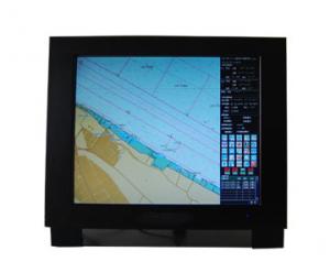
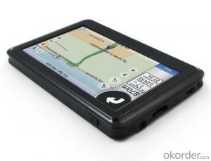
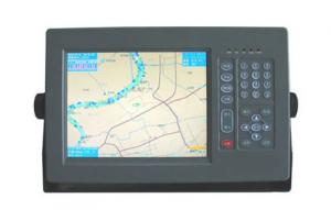
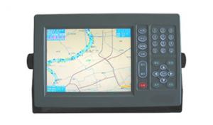
Marine GPS
- Ref Price:
-

- Loading Port:
- China Main Port
- Payment Terms:
- TT or LC
- Min Order Qty:
- 1 Set/Sets set
- Supply Capability:
- 1000 Set/Sets Per Year set/month
OKorder Service Pledge
OKorder Financial Service
You Might Also Like


Features of Marine GPS
- Designed to comply with the latest standards and resolutions set by IMO, IHO and IEC.
- The electronic charts to be used are compatible with S-57 format.
- The inputs include GPS, AIS, HDG and other data.
- For GPS data, either internal GPS or external GPS input is applicable.
- CCStype approval.
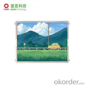
Specifications of Marine GPS
Display |
|
Resolution: | 1280 x 1024 |
Color: | TFT |
Display Area: | 17” or 19” |
Interface |
|
Input/Output: | 1. AIS input (RS232 and RS422) 2. GPS input/output (RS422) 3. HDG input/output (RS422) |
Data Format: | IEC61162-1, -2 |
Data Display |
|
Own Ship: | Position, COG, SOG, Heading |
Route: | Planned route, Monitored route |
ARPA Targets: | Range, Bearing, Speed, Course, CPA and TCPA |
Others: | EBL, VRM |
Route/Waypoint: | More than 100 routes, 200 waypoints/route |
Power supply |
|
Processor: | DC24V |
Display Unit: | DC24V |
- Q:Is there any navigation aid in the era of OL? Download address!
- In the age of sail service ol for the use of third party plug-in game player will have severe punishment, once was detected using third party plugins, will be the title, even now no plug-ins, but previously used, it will also be detected.
- Q:Can the GPS satellite monitoring system be used in navigation?
- Of course, the navigation ability of the GPS system is no matter where, as long as it covers the range, and have accepted the device can be used on the ground for vehicles and other navigation sections, also in the sea for the ship navigation
- Q:How about GPS navigation, okay?
- Other car navigation, aviation and navigation, in recent years, the rapid development of the GPS is very popular with their outdoor sports watch bracelet.
- Q:I was playing in the era of OL navigation with the wizard button in how to set a more accurate route. Do not use sacred navigation, I would like to use a pure key simulation, there is no call memory, set, I hope the master to help me think of ideas, grateful
- I don't think it's good for him to go there without divine navigation.... Basically do not hang JJC do not have this.
- Q:Application of satellite positioning system
- Mainly for the ship, automobile, aircraft and other moving objects positioning navigation. For example:1 ocean navigation and incoming water diversion2 aircraft route guidance and approach landing3 vehicle autonomous navigation4 ground vehicle tracking and urban intelligent traffic management5 emergency rescue6 people travel and adventure7 personal communication terminal (with mobile phones, PDA, electronic map integration)8 time synchronization of electric power, post and telecommunication9 accurate timing of admission10 accurate frequency of admission
- Q:Small fishing boat. A remote fishing village. Reef。 Map。,,,,,,,,,,,,,,,,,,,,,,Know the trouble to help ah... Thank you.
- Dude, you say something, or you want to function, domestic Beidou system has, the foreign GPS also, but remember, must take the function of electronic chart, I met many fishermen and fishing boats in the sea, all with the use of electronic chart function of radar or GPS, it is said that the domestic commercial Beidou system and also, terminal equipment can be used, you need to consult the specific dealer!
- Q:Ancient navigation depends on navigation
- According to the "Zheng He Zheng He" charts, using hydrographic needle (24/48 azimuth compass navigation) with Ocean Star drawing operation (celestial navigation), at that time is the most advanced navigation technology. Zheng He's fleet, the day with the compass navigation, night watch stars and method is used to keep water compass heading.
- Q:High frequency. SSB radio. Satellite navigationI want to study marine electronic equipment, a variety of marine radar. High frequency. Single sideband radio. Satellite navigation. All the fish finder. Sounder maintenance and so on which can enlighten me, where is the training school, I graduated for several years, I want to learn the craft.
- A marine radar is enough for your study, you can consult the Xiamen Marine College Jimei University, where many teachers navigation equipment maintenance,
- Q:I would like to study the maintenance of marine radar navigation technology, I do not know where to go
- Students are advised to go to the school of information, Dalian Maritime University, or the Institute of navigation have relevant professionalWork is more, Shanghai, Shenzhen, Guangzhou have.
- Q:OL, what is the meaning of the removal of the entire team in holy navigation? What is the use?
- The rest of the team is the vessel abnormality occurs can also use props skills such as B ship A ship launch command (automatic argument premise A ship skill props)
1. Manufacturer Overview |
|
|---|---|
| Location | Jiangsu,China |
| Year Established | 2008 |
| Annual Output Value | US$1 Million - US$2.5 Million |
| Main Markets | Mid East;Eastern Europe;South America |
| Company Certifications | |
2. Manufacturer Certificates |
|
|---|---|
| a) Certification Name | |
| Range | |
| Reference | |
| Validity Period | |
3. Manufacturer Capability |
|
|---|---|
| a)Trade Capacity | |
| Nearest Port | Shanghai |
| Export Percentage | 81% - 90% |
| No.of Employees in Trade Department | 150 |
| Language Spoken: | English, Chinese |
| b)Factory Information | |
| Factory Size: | Above 20,000 square meters |
| No. of Production Lines | 20 |
| Contract Manufacturing | OEM Service Offered;Design Service Offered |
| Product Price Range | Average |
Send your message to us
Marine GPS
- Ref Price:
-
- Loading Port:
- China Main Port
- Payment Terms:
- TT or LC
- Min Order Qty:
- 1 Set/Sets set
- Supply Capability:
- 1000 Set/Sets Per Year set/month
OKorder Service Pledge
OKorder Financial Service
Similar products
New products


Hot products
Related keywords

