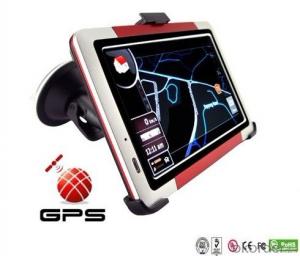

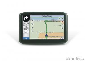
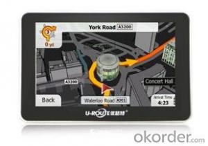
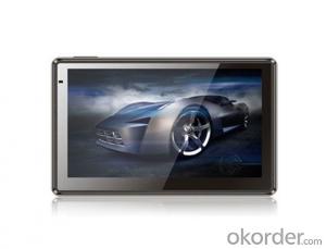
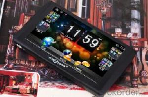
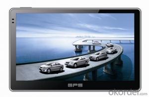
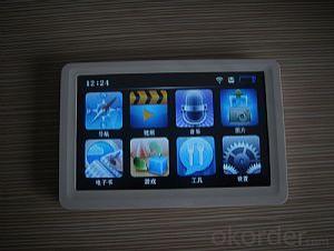
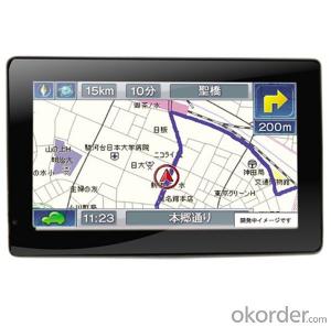
Popular 5" Portable GPS Navigation Device High Solution 800*480 pixels TFT Touch LCD
- Ref Price:
-

- Loading Port:
- China Main Port
- Payment Terms:
- TT OR LC
- Min Order Qty:
- -
- Supply Capability:
- -
OKorder Service Pledge
OKorder Financial Service
You Might Also Like


Popular 5" Portable GPS Navigation Device High Solution 800*480 pixels TFT Touch LCD
Specification:
Appearance | Display | 5" high solution TFT Touch LCD 800*480 pixels |
Size | 130*85*15mm | |
Weight | ~300g | |
System | CPU | CPU: MTK, 500 MHZ |
GPS Module | SiRF ATLAS III 20 Channel (SiRF is the most used and famous GPS technology company brand) | |
SDRAM | 128MB | |
Antenna | Built-in high sensitive, 0.1m/sec | |
Memory Slot | Micro SD/TF Card, support up to32GB | |
USB Slot | USB Client 2.0, mini USB port | |
Earphone output | 3.5mm | |
GPS accuracy: | Position - Less than 10 meters (33 feet), 95% typical velocity - 0.1 meters per second steady state | |
O/S system | WinCE NET 5.0 | |
Function | FM Transmitter: | Play music on the TF card over your car radio system |
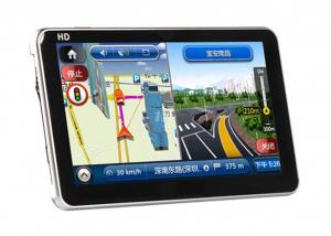
GPS: | Support 2D and 3D map over world | |
Video: | MP4, WMV, AVI, MPEG, ASF, 3GP | |
Audio: | WMA/MP3, Build in speaker | |
Photo: | JPG, BMP, PNG, GIF | |
E-book File: | TXT | |
Game | More than 10 Games. | |
AVIN (optional): | Connect with video signal | |
Bluetooth (optional): | Handfree phone | |
Digital TV (optional): | ISDB-T | |
Language: | Multi-language for device, map program and audio guidance: Supports Chinese, English, German, French, Spanish, Dutch, Hungarian, Czechs, Danish, Norwegian, Swedish, Portuguese, Italian, Japanese, Finnish, Romanian, Greek, Russian, Polish… | |
Battery | Built-in rechargeable Li-battery 1250mAh |
- Q: Civilian GPS accuracy in 10 meters or so, how to achieve accurate positioning navigation? Is the signal received by the GPS sent by satellite or sent from other places? If it were sent by satellite, what's the difference between the GPS on the car and the handheld GPS? Is it authorized?Please explain!
- We use the GPS receiver, handheld and vehicle, in addition to the model power, there is no difference, is the direct receipt of satellite signals, the use of satellites is a civilian satellite, should belong to the license.
- Q: Car GPS navigator, which brand is better?
- Caska is one of the best domestic navigation navigation, quality is very good,Recommend。 The latest generation of caska pilot series voice navigation products are equipped with "one button" function in traffic safety and ease of bring a new revolution, the new system realizes the speech control command to replace the traditional menu operation, more important is the access to completely change the vehicle communication. The traditional input method keyboard, handwriting recognition physical operation device, which is time-consuming and is not safe and easy to input errors, while caska PTT function is the voice recognition, speech processing based on Bluetooth technology integration, speech synthesis, speech recognition, voice control technology, to promote the electronic smart car from manual to sound change, through "sound system", "sound to help drive" mode allows the driver to maintain an optimum driving state, so that the owners do not have to worry about getting lost, driving trip to enjoy easy, which makes the driver to enjoy the journey of multiple dimensions has been upgraded from security to liberation. The driver of the limbs and body and mind.
- Q: I bought a 2 NISSAN Teana, car DVD is converted up (no brand. With GPS navigation,...). Friends DVD's memory card to help download songs, the inside of the mess of documents are deleted, and now the navigation can not be used (there is navigation on the screen, but the press did not react, touch screen). I would like to ask you, what is the program deleted, or deleted the map, if you delete what should I do? Please explain it, thank you!
- Upstairs is correct, ha ha.Careland map folder: NaviOneCityonmap map folder: CJTRoad map folder: RatiYou insert your memory card into your computer to see if there are any map folders in it. No, you need to reinstall it.
- Q: Open navigation interface, there is no map display, there is a satellite, that is, the light shows their own arrows, the other blank
- Did you enlarge the map?
- Q: Is the new Carnival special navigator, other functions can also be careless, GPS signal reception is poor, sometimes have to wait to receive ten minutes before, hoped the knowledgeable friends can instruct me. Thanks in advance.
- In the exclusion of weather reasons (thicker clouds) of the navigation signal to receive the inherent impact, in daily use, many owners also have a certain use of errors. The most common habit is to open the navigator and drive immediately to search for satellite signals on the road. However, it has been proved that the method of receiving signals while driving is several times slower than the normal acceptance of the vehicle.The correct approach should be to park the vehicle in a relatively open position. In the stationary state of the vehicle, first open the navigator and set it up. In general, the speed of star insertion is generally not more than ten minutes even after a cold start (such as opening the night before and opening in the morning). Drive after you find the satellite signal. Some owners love in the underground parking lot vehicle is started, the first open car navigator, such as the ground, think it can receive the signal, this practice effect is the same as above, it is difficult to quickly find the signal.The navigator in the use of six months to a year or so, if you keep the right way, still found the phenomenon of signal receiving speed, can go to the dealer to explain the situation, and ask the person to replace the antenna. In addition, you can also add your own external antenna. This external antenna is actually equivalent to the navigator to increase the signal amplification function.
- Q: Does vehicle navigation require traffic? Do you need money?
- Vehicle navigation system stored in the national map, electricity can be used, no need to flow, but the inside of the navigation map data is dead, the majority is updated once a year, not update will be lost (some road a year ago may now change to go somewhere else, now the house is displayed on the map, and here the road, which is very dangerous), so that the map to update, update the map some for a fee
Send your message to us
Popular 5" Portable GPS Navigation Device High Solution 800*480 pixels TFT Touch LCD
- Ref Price:
-
- Loading Port:
- China Main Port
- Payment Terms:
- TT OR LC
- Min Order Qty:
- -
- Supply Capability:
- -
OKorder Service Pledge
OKorder Financial Service
Similar products
Hot products
Hot Searches
Related keywords

