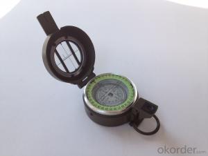


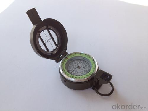


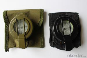
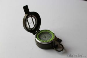
Army or Military Compass DC60-1B
- Ref Price:
-

- Loading Port:
- Tianjin
- Payment Terms:
- TT OR LC
- Min Order Qty:
- -
- Supply Capability:
- 5000 pc/month
OKorder Service Pledge
OKorder Financial Service
You Might Also Like


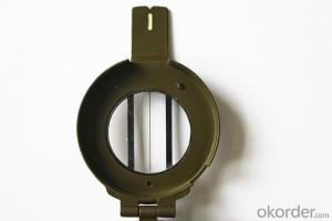
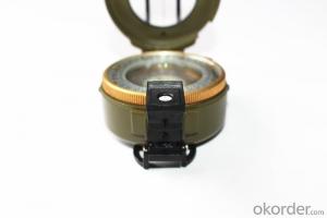
Model: DC60-1B
Name: outdoor hiking or military compass and army compass, metal compass and marching compass in aluminium material
Product Origin: China
Supply Ability: 40,000 pcs/month
Minimum Order: 100 pcs
MOQ for OEM package: 500pcs
Detailed Product Description
Product Size: 90*62*35 (mm)
Color: Army Green, Military green,
Material: Zinc alloy
Features:
1)Can easily folds to fit in your pocket
2) The compass is highly accurate and features a liquid-damped compass card with a luminous dial that can easily be read at night, and a standard bezel with two yellow lines at 45 degree angles
3) The compass card has both the standard 0 - 360 degree scale, as well as the 0 - 64Mil scale (one yard at 1,000 yards)
4) The bezel rotates with detents every 3 degrees so you can change the heading reference a known amount without looking at the compass
5) The front sight has a magnifier to simultaneously view the magnetic heading when taking a sight
6) A second magnifier assists in reading the magnetic heading when direct viewing from above
7) When unfolded flat, the marching compass has a straight edge with a standard 1:25,000 or 1:50000 map scale
8) This compass is protected by a durable cast metal case painted dark black with military drab
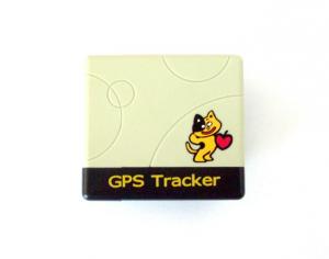
- Q: How to shield the signal of GPS vehicle locator
- This year, people really strange good features do not have to block up
- Q: Children's GPS positioning mobile phone watch need to install a phone card
- Look at what you want to buy, and some need a phone card, and some have been burned directly without the card
- Q: How to cancel QQ service positioning system
- The second step: log on to QQ, click on the upper left corner of the avatar to enter";The third step: in the settings interface, click contact, privacy";The fourth step: to enter the contact, privacy interface, the "visible to the nearby" option can be closed.
- Q: Millet 3 update system, GPS positioning in which settings?
- The following is the specific operation into the millet 3 mobile GPS positioning settings:1, open the phone, and then enter the settings.2, and then select the other advanced settings to enter, click Security privacy.3, and then enter the location information, and then select the settings you need to locate the GPS.
- Q: GPS positioning is how to get offline
- 3, positioning the phone card arrears, or change the phone card package, Internet access is disabled.Details of the mobile phone operator consulting card (example: Mobile: 10086, China Unicom: 10010), consulting mobile phone card is not arrears, there is no open Internet access, Internet features have not come into effect, the package has not been changed. If it is a mobile phone card, be sure to open GPRS, access point must be cmnet.Mobile communication.
- Q: I would like to do a GPS positioning system to monitor the location of parking spaces within the car loading GPS locator console display map and the location of the vehicle on the map
- The 2 thing GPS positioning system car parking no parking on the specific stop with the camera set with to install 3G recorder is too difficult to do parking 3G recorder is ideal I loaded my love equipment installed satellite positioning and camera like travel license outside
- Q: Use method of real carpenter locator
- The main use of GPS:GPS comparison fee battery, the majority of GPS using four alkaline batteries have been available for 20-30 hours, the time on the manual is not very accurate, should pay attention to the use of spare batteries for long periods of time. Most of the GPS has a permanent spare battery, which can ensure that the data in the memory is not lost when there is no battery. Because GPS is not in the direction of the static indicator function, so also carry a small compass is useful. Marker signs, GPS provides a way to the default standard, such as LMK001, memory, although it can be changed into a better remember the name, but it is inconvenient to input, use the arrow to choose the letter very hard, two is generally only a very short English name, such as 6 or 9 the letter is still not good, remember, and then take a small tape recorder / interview record at any time, it is a good idea.
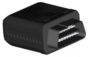
- Q: How to install car GPS positioning tracker
- 1, car GPS positioning tracker is divided into three kinds: wiring (and different functions, functions, wiring is a little bit more complicated), OBD interface, with strong magnetic2, OBD interface installation is more convenient, like an GT500 grain car, just plug in the steering wheel below the OBD port can be
- Q: How much does it cost to install a concealed GPS locator? Which brand is good
- On the car GPS locator price, GPS positioning system price is mainly composed of two parts, part of the SIM card traffic costs, and the other part is the price of the GPS locator itself.SIM card traffic costs are fixed, generally 5 yuan package monthly 30M traffic, so that the cost of a year is $60, is still very cost-effective. SIM card is an ordinary mobile phone card, recharge and pay the same way to pay.GPS locator itself hardware price difference will be relatively large, there are about 150 yuan cheaper. High price of more than one thousand yuan. Suggest that you choose between $260 - 360 yuan GPS locator. Because of the price of the car GPS locator highest cost.What is a good brand of car GPS locator? GPS positioning system price
- Q: GPS tracker and GPS detector is not ossessione
- Good question, this is a bit of a friend.GPS positioning tracker is to prevent the theft of vehicles and other reasons, can not find the car born. And now the use of a very wide range, motivation is no longer so simple. Is the so-called, everything has an opposite, you want to track me, and I do not want to let you know, so I developed the detector, find your security GPS, demolition, you do not know.One foot in mind, I have the impression that science and technology is a more standard equipment interference detection signal GPS. With the progress of science and technology, which is the enemy of their own technology in the end which strong, unknown.AskNice to say
Send your message to us
Army or Military Compass DC60-1B
- Ref Price:
-
- Loading Port:
- Tianjin
- Payment Terms:
- TT OR LC
- Min Order Qty:
- -
- Supply Capability:
- 5000 pc/month
OKorder Service Pledge
OKorder Financial Service
Similar products

Hot products
Hot Searches

