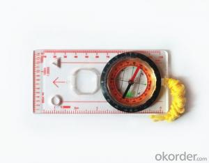
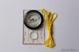
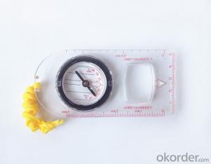
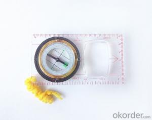
Transparant Map Scale Compass DC45-C
- Loading Port:
- China Main Port
- Payment Terms:
- TT OR LC
- Min Order Qty:
- -
- Supply Capability:
- -
OKorder Service Pledge
OKorder Financial Service
You Might Also Like
Model: DC45-5C
Name: Professional map compass, ruler compass
Product Origin: China
Supply Ability: 10,000 pcs/month
Minimum Order: 50 pcs
MOQ for OEM package: 500pcs
Product Size: 128*60*16 (mm)
Features
1, professional usage: orientation, distance measuring, measuring slope, azimuth and pitching Angle measurement, drawing, a magnifying glass
2, high quality compass with neck rope, portable and rugged
3, ACRYLIC material, about 2mm thick
4, Damping Dial: to keep the stability of the pointer, more suitable for outdoor
environment.
5, Accuracy: accurate and clear, there were 360 degrees azimuth Angle, outer ring is 64-00 system, Liquid filled in the compass for reliable readings.
6, Magnifier function
- Q:My friend is in use, the difference is not big, professional handset (smart or Magellan bulky, but 3 case), but the price is expensive, but can not call and map is very rotten, endurance of 10 hours (dry battery) the mobile phone also has all the time. Know friends say, I mainly in the suburbs! Thanks
- Professional GPS is mainly used for acquisition, is not used for navigation; of course, some professional GPS can install third party software, the accuracy is higher than the phone, this is positive;Mobile navigation is only used for navigation, navigation, path analysis and navigation functions, not the acquisition of maps of the instrument.
- Q:Is it accurate to measure highway mileage with GPS handheld
- As long as you can receive more than four satellites, and the signal is good, the accuracy should be high.
- Q:Handheld GPS purchaseHandheld GPS navigator!Is mainly used for tourism, I said is not a mobile phone, is a more professional handheld GPS navigator for travel outside! Handheld GPS navigator can voice navigation?
- The more high-end is good, clever and wheat zalun, many outdoor enthusiasts are used to this, hiking, cycling and other applications are relatively wide, is an American brand, Mazelen returned to the U.S. Army GPS, and as Ma Ying-Jeou ring when riding on the handlebar also puts a high out of this two 60CSX. the brand in the nature, the price is more expensive, in more than 2000, but the best is to the store to buy.
- Q:What do you need to test for GPS?
- 6 antenna type to give you a good positioning, GPS receiver requires at least 3 ~ 5 satellites are visible. If you are in a canyon or on both sides of the street, or in the dense jungle, you may not be able to contact with enough satellites, so that you can not locate or only two-dimensional coordinates. Also, if you're in a building inside, you may not be able to update your location, some GPS receivers have a separate antenna can be attached to the windshield, or built-in active antenna, or an external active antenna can be placed on the roof, the receiver which helps you get more satellite signals the. 7 other indicators to buy GPS equipment, according to the needs and use of the environment, size, weight, waterproof, shockproof, dustproof performance, high temperature resistance, power consumption and other indicators should be taken into account.
- Q:Verify the accuracy of the GPS device to buy back, the way is to use Android under the'gps state 'software, to test the accuracy of real-time single point positioning.1 with two sets of the same Android Tablet Computer (custom machine, type of bad) in the same position for receiving, find that the accuracy is the same (software, are 1-2 meters), but the position would be poor 10 meters or more. It's in the same place.The 2 one is the Android tablet computer, a mobile phone is HTC G10, also received together in the same position, find that the accuracy is not the same as (the latter 20 meters or so), but also may be about 10 meters position difference.The accuracy of this GPS device can reach 1-2 meters, while the same location in real-time single point positioning error of 10 meters, a reasonable explanation.
- Oh, together with the exchange of learning, mutual verification, I said that is my experience. Software tells you that the accuracy is handled and limited, especially for some third party software. If you do not limit the scope of the conditions, the limit is too difficult to determine. If the satellite in poor condition, serious occlusion, satellite time difference, let alone ten meters, a few dozen a hundred meters are possible. Under normal circumstances, single point positioning accuracy is about ten meters, of course, sometimes all aspects of the conditions are very good, a few meters are also some. As for the accuracy of the GPS that you say htc10 and tablet computer, to this kind of navigation type GPS, from the respect of the respect that the instrument says, the accuracy should be in 10 meters to 15 meters (all the conditions are all right). Oh exchange!
- Q:What is the difference between a hand-held GPS and a car's onboard navigator
- Effect of GPS navigation handheld as vehicle, as the vehicle with what map, the hand-held GPS is mainly used for point positioning, measuring area, high precision, good anti 3, my understanding is that
- Q:Highway measurement with GPS I do not know which of the base station settings and mobile station settings I are very vague, to the instrument to build a coordinate system how to build the relevant issues to me
- Defects of conventional measurement methods:1, the specification of the length of the attached wire, the length of the wire and the length of the wire between the nodes have strict requirements, generally for high grade roads are required to meet the requirements of the first line. In this way, the length of the wire shall not be more than 10 km, or the length of the wire shall not exceed the length of the wire attached to the attachment of the wire length of 0.7 times. This requirement is generally difficult to achieve in the actual work, often appear super standardized operations.2, to collect the starting point for the general route of measurement and control is difficult to ensure the same measurement system, the measurement and measurement, often in the city of control points mixed together, the compatibility between systems, if the starting point is not compatible, is bound to affect the quality of measurement.3, serious damage to the national site, the impact of measurement operations. Due to the country's basic control points, mostly completed in 50s and 60s, after more than 30 years, some point due to the needs of economic construction is destroyed, and some people because of the lack of knowledge of human destruction. Route survey work in these areas, often in the 50 km above all can not find the wire control points. The quality of the route control survey is not guaranteed.4, ground visibility difficulties often affect the implementation of conventional measurement. The control points of the general route shall be located within 300 meters from the course. Due to visibility reasons, it is difficult to meet the conditions, even in a large range, and the dense shrub forest area, simply can not implement conventional control measure.
- Q:Professional handheld GPS GARMIN (DR) how to use
- Handheld GPS purposes, the measurement of soil area, linear navigation, auxiliary fishing waypoint navigation point information, traffic data display, such as the use of functional machines should be used manual
- Q:Jia Ming etre20 handheld GPS good
- The new generation of the eTrex series is the first generation of user level receivers that can track both GPS and GLONASS satellites. GLONASS global navigation satellite system developed by Russian Federation, fully put into use. When using the GLONASS satellite, the average time for the receiver to lock the target is about 20% faster than GPS. And, when using both GPS and GLONASS, the receiver has the ability to lock more than 24 satellites as compared to GPS alone.
- Q:Fuxin coordinates with the mapping of the seven parameters are what ah there is no professional knowledge to tell my brother I need to fill the gps... Thanks.
- Three translation parameters Delta X, Delta Y, Delta Z, three rotation parameter w X, Omega Y, Omega Z and a zoom M, these parameters need to be calculated in a fixed point under different ellipsoid!
1. Manufacturer Overview |
|
|---|---|
| Location | |
| Year Established | |
| Annual Output Value | |
| Main Markets | |
| Company Certifications | |
2. Manufacturer Certificates |
|
|---|---|
| a) Certification Name | |
| Range | |
| Reference | |
| Validity Period | |
3. Manufacturer Capability |
|
|---|---|
| a)Trade Capacity | |
| Nearest Port | |
| Export Percentage | |
| No.of Employees in Trade Department | |
| Language Spoken: | |
| b)Factory Information | |
| Factory Size: | |
| No. of Production Lines | |
| Contract Manufacturing | |
| Product Price Range | |
Send your message to us
Transparant Map Scale Compass DC45-C
- Loading Port:
- China Main Port
- Payment Terms:
- TT OR LC
- Min Order Qty:
- -
- Supply Capability:
- -
OKorder Service Pledge
OKorder Financial Service
Similar products
New products
Hot products
Related keywords
