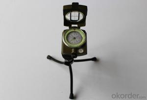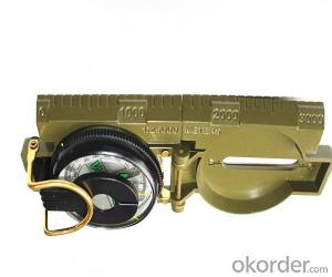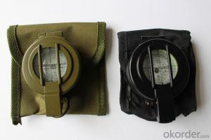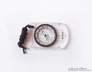


Mapping Mini Compass with Different Scales Ruler
- Ref Price:
-

- Loading Port:
- Tianjin
- Payment Terms:
- TT OR LC
- Min Order Qty:
- 50 pc
- Supply Capability:
- 5000 pc/month
OKorder Service Pledge
OKorder Financial Service
You Might Also Like


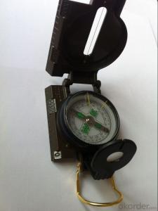
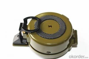
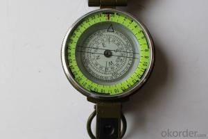
Model: Compass DC35-1B
Name: Professional map compass, ruler compass
Product Origin: China
Supply Ability: 10,000 pcs/month
Minimum Order: 50 pcs
MOQ for OEM package: 500pcs
Product Size: 70*48*9 (mm)
Features of Compass DC35-1B:
1, professional usage: orientation, distance measuring, measuring slope, azimuth and pitching Angle measurement, drawing, a magnifying glass
2, high quality compass with neck rope, portable and rugged
3, ACRYLIC material, about 2mm thick
4, Damping Dial: to keep the stability of the pointer, more suitable for outdoor
environment.
5, Accuracy: accurate and clear, there were 360 degrees azimuth Angle, outer ring is 64-00 system, Liquid filled in the compass for reliable readings.
6, Magnifier function
5, with ruler on compass DC35-1B,
6,for map measure and drawing
7,one meter neck rope,
8,Liquid filled in the compass for reliable readings,
9,Magnifier function.
10,Support OEM

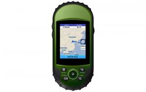
- Q:Beidou portable navigation 510 HD port number is how much?
- Baidu to download a GPS port, baud rate detection tool, decompression on the computer, copy to a blank on the SD card inserted into the navigator, you can display the navigation port, baud rate, screen resolution.
- Q:My portable GPS is not connected to the computer
- Shut down the soft test some machines are to open the USB option on the machine some computers need to be connected to the back of the machine USBSome machine data matching is also a factor
- Q:I am using the portable navigation, I want to upgrade a map, want to know the upgrade method, is not my computer navigation and even, after the navigation in the navigation folder to delete the whole, download the new folder to the navigation in the navigation and then changed the original navigation in the name of the folder can it? Do you need to do something more?
- Two, the three software is copied to the root directory of the TF card,Enter the navigation set - "navigation path settings", pointing to the start of the software in the.EXE file can be measured separately:The physical port and baud rate of the navigator; the free port number of the navigator;Navigation hardware system, such as: operating system category, CPU type and frequency, memory, screen resolution, etc..
- Q:When the upgrade is not careful to restore the factory settings, and now the boot screen function can not be used, how to solve
- Restore factory settings do not touch the screen does not work, firmware problem
- Q:How to update the new route GPS portable navigator
- If it is a genuine map, please activate the map on the official website of the vendor and download the official website of the upgrade package after the original map can be covered
- Q:I've upgraded built-in desktop software, electronic dog do not know how to upgrade
- You can consult the manufacturer phone or purchase location
- Q:Where is the 7 - Inch portable navigation tape recorder
- Hello, can be installed in the corner of the table glass, help to watch does not affect the vision, I am glad to answer your questions, I hope to help you, I wish you a pleasant car!
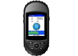
- Q:Do I have to have a flow or a phone card? How much is the cost? The most simple, only positioning it?To know how to explain. What is the core of GPS positioning? Mobile phone signal flow or signal? Or a single chip?
- The core is the GPS chip, the phone receives the satellite signal through the calculation of the chip to get your position, you can not flow.There is a AGPS technology, you can first use the mobile base stations to determine the approximate location, and then through the analysis of the signal receiving chip to which satellite positioning, this way more quickly, but want to consume a little data flow.
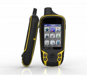
- Q:Portable navigator function? Portable navigator function?
- Whether it is on the car or portable navigator has the following features: 1 all-weather real-time satellite navigation signal. 2 live voice navigation, driving can automatically broadcast the name of the road.
- Q:Portable navigation sucker is always out of
- You can change the owner of the suction cup can be made of rubber or hard to change in the hope that I would like to help you wish you a happy [car questions asked the division of 4S professional technicians to solve 10 minutes]
1. Manufacturer Overview |
|
|---|---|
| Location | |
| Year Established | |
| Annual Output Value | |
| Main Markets | |
| Company Certifications | |
2. Manufacturer Certificates |
|
|---|---|
| a) Certification Name | |
| Range | |
| Reference | |
| Validity Period | |
3. Manufacturer Capability |
|
|---|---|
| a)Trade Capacity | |
| Nearest Port | |
| Export Percentage | |
| No.of Employees in Trade Department | |
| Language Spoken: | |
| b)Factory Information | |
| Factory Size: | |
| No. of Production Lines | |
| Contract Manufacturing | |
| Product Price Range | |
Send your message to us
Mapping Mini Compass with Different Scales Ruler
- Ref Price:
-
- Loading Port:
- Tianjin
- Payment Terms:
- TT OR LC
- Min Order Qty:
- 50 pc
- Supply Capability:
- 5000 pc/month
OKorder Service Pledge
OKorder Financial Service
Similar products
New products

Hot products