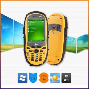


GIS Data Collector
- Ref Price:
-

- Loading Port:
- China Main Port
- Payment Terms:
- TT or LC
- Min Order Qty:
- 10 set
- Supply Capability:
- 200 Sets Per Day set/month
OKorder Service Pledge
OKorder Financial Service
You Might Also Like


Key Features:
1. Fast GPS receiver with 50 channels, high sensitive and anti-interference antenna.
2. Optional mobile operation system: Windows Mobile6.1 or Mobile6.5 or Android 2.3, high compatibility.
3. 3.5G communication mode, Bluetooth, WIFI, multi-mode data transmission for whole T20 series, camera and microphone for multimedia data collection, RFID provides convenient conditions for asset management users.
4. 5 megapixel camera, automatic focus, adding geographic coordinate function for photos.
5. Double input modes: Touch screen and keyboard.
6. SDK support.
7. 3-proof design IP65, compact, portable and convenient.
Product Models:


Technology Specs:
GNSS performance | Channel | 50 channe,l L1 |
Antenna | High sensitive, anti-interference antenna | |
Real Time Accuracy | 3~5M | |
DGPS(RMS) | 1~3M(SBAS),<1m(RTCM Input) | |
System | Operation System | Microsoft Windows Mobile6.1 or Mobile6.5, or Android 2.3 |
CPU | 806MHz | |
Memory | 256MB RAM | |
Output | Max. 4Hz output | |
Equipment Character | Camera | 5 megapixel camera with autofocus, Max. resolution 2592*1944 pixel, supports photos and position coordinate collection. |
Keyboard | 10 digital keys, supports figure, English input, 9 system function keys, provides SDK, supports user-defined, 3 quick start keys, visible in night. | |
Microphone | Supports voice recording | |
Speaker | Built-in speaker | |
TF Memory Card | Standard 2G, Supports Up To 32G | |
Communication Function | Cellular Voice&Data(Optional) | HSDPA,3.5G/WCDMA/GPRS |
Bluetooth | 2.1+EDR | |
Wi-Fi | Supports 802.11b/g/n, wireless LAN | |
RFID (optional) | 13.56MHz RFID | |
USB port | MiniUSB2.0 | |
Series port | Supports Protocol RS232 | |
Physical | Display | 3.2”(diagonal ) touch screen |
Display Effect | 320*240 pixel, 260,000 colors | |
Waterproof | IP65 | |
Drop | Naturally 1.2 m drop over concrete | |
Working Temperature | -20°C ~ +60°C | |
Storage Temperature | -30°C ~ +70°C | |
Dimension | 165*78*28mm | |
Net Weight | 230g(including battery) | |
Packing | Packing Box Dimension | 205*135*85mm |
Gross Weight | 701g | |
Power Supply | Battery | 3100mAH rechargeable and replaceable Li-ion battery, 10H working time |
Languages | Operation System languages |
Chinese(Simplified) Chinese(HongKong), English, Spanish, French, German, Dutch, Italian, Russian (It is discussable to change the language provided the quantity is large) |
Field Software Languages | Chinese, English,Portuguese(Brazil),Spanish,Romanian, Swedish, Turkish,Polish, Arabic, Estonian, Finnish, French, German, Greek, Hebrew, Hungarian, Japanese, Korean, Latvian, Lithuanian, Norwegian, Pashto, Czech, Danish, Dutch |
Remarks:
1. Specifications subject to change without notice.
2. Accuracy and reliability depend on the quality of GPS signal and working environment.
3. Battery life time and charge cycles will vary with conditions and environment of use.
4. Software may vary depending on configuration.
5. Weight varies from configurations and optional accessories.
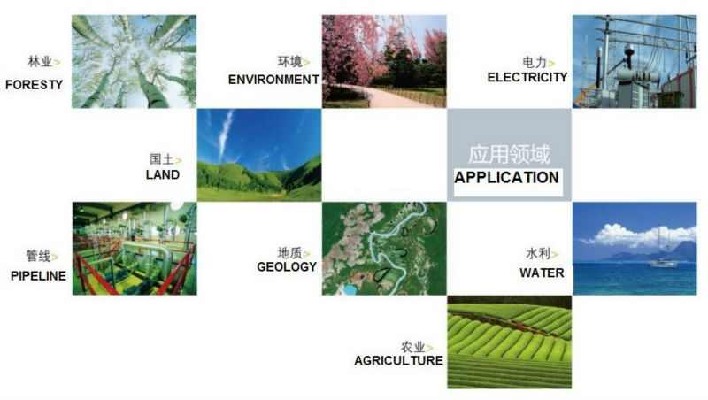
Application:
Utilities: Asset management, rapid response.
Local government: Asset management, issue reporting, emergency mangement.
Environmental management:Data collection.
Packing:

Delivery:

- Q:In addition to the parameters, that is the problem of the machine, what method can reduce the error of these two machines to a minimum. Because, at the same time to find a coordinate. The gap is too big.
- GPS was in error with 10 meters, with the star search results, related to the environment, if the precision is high, as long as the use of handheld GPS submeter or handheld RTK
- Q:What factors affect the handheld GPS receive signal?
- In addition to not see the sky (such as indoor, underground, dense forest) and narrow alleys and tall buildings on both sides of the environment, there will be no impact. Many GPS has 12 receivers (antenna unit), as long as it can capture 3 satellites can be three-dimensional positioning (including height), the 2 satellites can be flat positioning.
- Q:How to hand GPS eTrex H data to the computer
- Computer installed on the MapSource software, connect the data cable, upload waypoints and tracks can be!
- Q:Welcome to make comments on the existing GPS tour pal what shortcomings to answer the more detailed the better
- Fifth elements: the terrain map is the main project of outdoor sports climbing, mountain climbing is very exhausting, we usually do a plan will be completed on schedule, a good plan should be to our destination in the manual run out before. And if you want to do this, it must be on the road difficult to have a correct anticipation. But this time, with the terrain map GPS can come in handy, the mountains and the altitude of the understanding, we need to know about these sections spend much time and energy. And the general GPS map, is unable to meet the needs. So we'd better buy a map with contour terrain data of professional grade GPS, make your own outdoor journey do in our hands.
- Q:Can you buy a good handheld GPS in China? FiveTrouble master recommended several professional handheld GPS brand, in addition to handheld GPS can speed it? Thank you!!
- The main function is to use navigation as long as the navigation function can be used
- Q:Verify the accuracy of the GPS device to buy back, the way is to use Android under the'gps state 'software, to test the accuracy of real-time single point positioning.1 with two sets of the same Android Tablet Computer (custom machine, type of bad) in the same position for receiving, find that the accuracy is the same (software, are 1-2 meters), but the position would be poor 10 meters or more. It's in the same place.The 2 one is the Android tablet computer, a mobile phone is HTC G10, also received together in the same position, find that the accuracy is not the same as (the latter 20 meters or so), but also may be about 10 meters position difference.The accuracy of this GPS device can reach 1-2 meters, while the same location in real-time single point positioning error of 10 meters, a reasonable explanation.
- You are very normal, the tablet computer and mobile phone antenna, not inside, the highest accuracy is about 10 meters, as ordinary navigation is good enough, to achieve centimeter level accuracy by GPS single is, that is to achieve the RTK measurement, is the application of professional measurement, now RTK or by the United States GPS satellite, not the United States GPS satellite as China Beidou mobile station and the base station is in need of mutual difference calculation to achieve accurate measurement. Now the single can receive SBAS signal, single precision up to 1-2 meters, the Northeast in some places to achieve sub meter level, which is the highest single precision can reach, is also used in field investigation using professional machine.
- Q:I am a handheld GPS precision is low, how to use to be able to improve certain accuracy
- If the carrier phase measurement function is not available, you have the maximum accuracy of GPS accuracy of 1-10This can only improve the observation environment using SBAS and other ways to improve the accuracy
- Q:Handheld GPS charge is not into electricity what is the reason
- Reason analysis:1, battery damage. 2, system failure. 3, charger reasons or bad contact.
- Q:Professional handheld GPS GARMIN (DR) how to use
- Would like to use the function of handheld GPS purposes, the measurement of soil area, linear navigation, auxiliary fishing waypoint navigation point information, traffic data display, etc.
- Q:Fuxin coordinates with the mapping of the seven parameters are what ah there is no professional knowledge to tell my brother I need to fill the gps... Thanks.
- XYZ offset, XYZ twist, 6, plus a scaling factor.Seven parameters have to be calculated, or from the local surveying and mapping departments to.
1. Manufacturer Overview |
|
|---|---|
| Location | Guangzhou, China |
| Year Established | 1999 |
| Annual Output Value | US$ 45.75 Million |
| Main Markets | Korea; Iran; Indonesia; Philippine; Poland; Italy; Brazil; South Africa; Russia |
| Company Certifications | FCC; CE |
2. Manufacturer Certificates |
|
|---|---|
| a) Certification Name | |
| Range | |
| Reference | |
| Validity Period | |
3. Manufacturer Capability |
|
|---|---|
| a)Trade Capacity | |
| Nearest Port | Shenzhen; Guangzhou |
| Export Percentage | 8% |
| No.of Employees in Trade Department | 900 People |
| Language Spoken: | English; Chinese; Spanish; Arabic |
| b)Factory Information | |
| Factory Size: | Occupy 3000 square meters |
| No. of Production Lines | Above 5 |
| Contract Manufacturing | OEM Service Offered; Design Service Offered |
| Product Price Range | High; Average |
Send your message to us
GIS Data Collector
- Ref Price:
-
- Loading Port:
- China Main Port
- Payment Terms:
- TT or LC
- Min Order Qty:
- 10 set
- Supply Capability:
- 200 Sets Per Day set/month
OKorder Service Pledge
OKorder Financial Service
Similar products


New products


Hot products


Hot Searches
Related keywords

