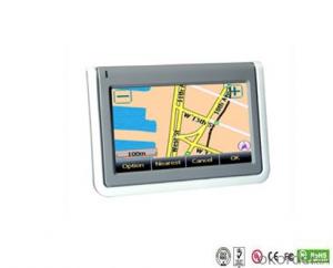
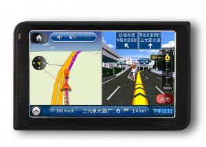
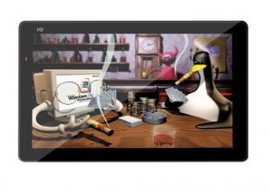
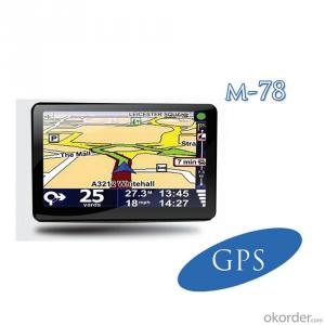
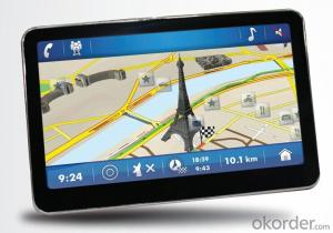
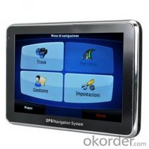
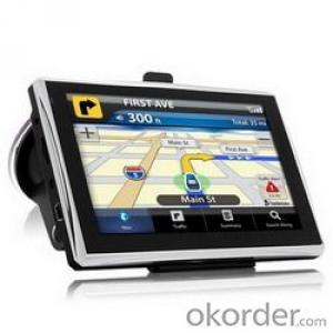
WinCE 4.3 inch GPS Portable Navigation Devices BT AVIN optional
- Ref Price:
-

- Loading Port:
- China Main Port
- Payment Terms:
- TT OR LC
- Min Order Qty:
- -
- Supply Capability:
- -
OKorder Service Pledge
OKorder Financial Service
You Might Also Like


WinCE 4.3 inch GPS Portable Navigation Devices BT AVIN optional
Specification
· Processor: Centrality Atlas III AT642 372MHz.
· Memory: Built-in 64 MB NAND flash, 64MB SDRAM. (if you have special requirements, we can provide 2/4/8 GB SDRAM)
· LCD Screen: 4.3Inch TFT-LCD,Touching Screen, Resolution 480*272.
· GPS Module: Internal high sensitive SiRF Star III module
· Precision: 3~10m, 90% accuracy.
· Antenna Sensitivity: 0.1 m/s.
· Audio Player: Supports MP3,WAV and MID Audio formats.
· Video Player: Supports MP4, ASF,WMV and AVI video formats.
· Photo viewer: Supports JPG, BMP,PNG and GIF formats.
· E-Book viewer: Supports TXT Format.
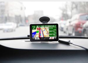
· Bluetooth function(optional): comes with Bluetooth Hand-free function. You can dial and receive mobile phone hand freely when driving after connecting the GPS and mobile phone.
· Rear-view function(optional): comes with Rear-view function. You can view when driving back forward after connecting with a camera.
· FM Transmitter: Built-in FM Transmitter (frequency: 87.5MHz~95.0MHz),
· FM transmitter refers to the songs on GPS and are launched into the car stereo player, like this will be very good sound quality.
· SD/MMC: With SD / MMC slots,
(if you have special requirements, we can provide 2/4/8 GB SD memory card)
· Battery: Built-in high capacity Lithium battery.
· Operation Temperature: Fahrenheit degree 32~ 140.0~60 Centigrade)
· Storege Temperature: Fahrenheit degree -4~ 140. (-20~ 60 Centigrade)
· Language: Supports Chinese ,English ,German, French, Spanish, Dutch, Hungarian, Czechish, Danish, Norwegian, Swedish, Portuguese, Italian, Japanese, Finnish, Romanian, Greek, Russian, Polish.
Our Advantages
1. Several years GPS manufacture experience with professional workers and professors.
2. R&D department, who can satisfy clients' demands on firmware and design, and technical supports. 3. SMT machine, GPS signal testing room, temperature and humidity cycling test machine, 12-hours burn-in testing for finish products, which ensure the high quality control.
4. A long term and reliable business relationship with our parts suppliers, who can give us priority on quality and delivery.
5. A Service-oriented sales team. Customer care is our top priority.
Quality Policy
1. Technic innovation, first high quality, and the uppermost client
Based on its "Customer First" focus, innovate continuously, to satisfy and exceed the customers' requirement.
2. Execute fully Quality System
Adhering the "Quality First" principle, satisfying all theclients and company members' need, and achieving the long time successful management.
3. Continuous reformation, self-improvement
Do analysis internal to improve quality management. Improve continuously, to meet customer's need.
- Q:Car GPS navigator, which brand is better?
- That is to find a special export brand, and recommend to you "INNVO" this brand, the main export
- Q:Does vehicle navigation require traffic? Do you need money?
- First, any car navigator is directly connected with the satellite, without the network, so it does not need traffic.Two, car GPS has two kinds, one is the navigation, navigation is one way to receive signals with good software has been downloaded in the instrument map is displayed, because have downloaded a good map so not networking, so as not to need to flow.One is GPS monitoring, the Y is two-way, not only receive, but also automatically send location information to the background software, to use the network, so you need traffic card support.
- Q:Civilian GPS accuracy in 10 meters or so, how to achieve accurate positioning navigation? Is the signal received by the GPS sent by satellite or sent from other places? If it were sent by satellite, what's the difference between the GPS on the car and the handheld GPS? Is it authorized?Please explain!
- 10 meters? Generally 3 to 10 meters, even in the auxiliary road can also show, so don't worry about inaccuracy, car with civilian is a meaning, are satellites, authorized? This... Do you mean to buy genuine goods? There is no need, nor can I buy it.
- Q:Open navigation interface, there is no map display, there is a satellite, that is, the light shows their own arrows, the other blank
- GPS vehicle navigation system which ah, settimio. The map is not piracy, suggest or buy brands, such as: China, Huayang what caska, Philco. These brands are very good, the national market doing well, quality is good, service is also very good.
- Q:Is the new Carnival special navigator, other functions can also be careless, GPS signal reception is poor, sometimes have to wait to receive ten minutes before, hoped the knowledgeable friends can instruct me. Thanks in advance.
- In the exclusion of weather reasons (thicker clouds) of the navigation signal to receive the inherent impact, in daily use, many owners also have a certain use of errors. The most common habit is to open the navigator and drive immediately to search for satellite signals on the road. However, it has been proved that the method of receiving signals while driving is several times slower than the normal acceptance of the vehicle.The correct approach should be to park the vehicle in a relatively open position. In the stationary state of the vehicle, first open the navigator and set it up. In general, the speed of star insertion is generally not more than ten minutes even after a cold start (such as opening the night before and opening in the morning). Drive after you find the satellite signal. Some owners love in the underground parking lot vehicle is started, the first open car navigator, such as the ground, think it can receive the signal, this practice effect is the same as above, it is difficult to quickly find the signal.The navigator in the use of six months to a year or so, if you keep the right way, still found the phenomenon of signal receiving speed, can go to the dealer to explain the situation, and ask the person to replace the antenna. In addition, you can also add your own external antenna. This external antenna is actually equivalent to the navigator to increase the signal amplification function.
- Q:I bought a 2 NISSAN Teana, car DVD is converted up (no brand. With GPS navigation,...). Friends DVD's memory card to help download songs, the inside of the mess of documents are deleted, and now the navigation can not be used (there is navigation on the screen, but the press did not react, touch screen). I would like to ask you, what is the program deleted, or deleted the map, if you delete what should I do? Please explain it, thank you!
- In the first system settings where to find the set of navigation path with a look at the memory there is no map, it is available to set the path, if not is to map out, need to copy into the map, copy the path into the future to set the navigation file. Very simple
1. Manufacturer Overview |
|
|---|---|
| Location | |
| Year Established | |
| Annual Output Value | |
| Main Markets | |
| Company Certifications | |
2. Manufacturer Certificates |
|
|---|---|
| a) Certification Name | |
| Range | |
| Reference | |
| Validity Period | |
3. Manufacturer Capability |
|
|---|---|
| a)Trade Capacity | |
| Nearest Port | |
| Export Percentage | |
| No.of Employees in Trade Department | |
| Language Spoken: | |
| b)Factory Information | |
| Factory Size: | |
| No. of Production Lines | |
| Contract Manufacturing | |
| Product Price Range | |
Send your message to us
WinCE 4.3 inch GPS Portable Navigation Devices BT AVIN optional
- Ref Price:
-
- Loading Port:
- China Main Port
- Payment Terms:
- TT OR LC
- Min Order Qty:
- -
- Supply Capability:
- -
OKorder Service Pledge
OKorder Financial Service
Similar products
New products


Hot products

Related keywords

