Surveying GIS K9
- Ref Price:
-

- Loading Port:
- China Main Port
- Payment Terms:
- TT OR LC
- Min Order Qty:
- -
- Supply Capability:
- -
OKorder Service Pledge
OKorder Financial Service
You Might Also Like


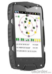
PJK 8 is a GPS data collection devices based with smart tablet Android operating system; 3.5 Cunban through the half- screen which is visible under bright light , high-resolution , ultra-thin , rugged design, easy to complete the wild variety of environments data collection ; built-in 3G data acquisition allows interaction within and outside the industry that has quickly realized .
Product Features
1, the basic functions
Operating system : Android 4.0, massive applications at your fingertips
Processor : 1GHZ processor speed
Memory capacity RAM: 512MB ROM: 4G
Memory card : MicroSD (TF) card , up to 32GB
2 , data collection
Data acquisition system with professional mobile GIS data collection , field mapping, waypoint storage coordinates to calculate the length , angle , and other areas of field measurement data , with a key two-coordinate conversion function .
3, GPS features
Differential : Support SBAS (MSAS, WAAS, EGNOS)
Real-time differential :1-3m
Single precision :3-5m
4 , communication performance
Built-in GSM and WCDMA communications , high-speed data transfer easy , can support voice calls
Bluetooth : 2.1 + EDR
WIFI: Support 802.11 Wireless LAN
USB: 2.0
5, the extended application
5 million pixel camera , 300,000 auto-focus camera ,
Video capture,
Built-in microphone supports voice attribute collection
Built-in electronic compass ,
Under no circumstances can indicate GPS direction , support multiple GPS intelligent navigation software
Support for emergency lighting and portrait and landscape screen automatically switches .
1, the physical properties of
Size : 125 * 65.5 * 20.5MM
Weight : 204G
Working temperature: -20 to 65 degrees
Storage temperature : -40 ℃ ~ 70 ℃
Humidity : 100 % non-condensing
Waterproof and dustproof : IP67
Anti- fall drop : Anti 1.5 meters free fall
Roll : Roll 1000 0.5 m height
Rugged and lightweight : GE Industrial grade high fire-retardant materials plus lightweight structure designed to allow field operations no longer be a burden.
2 , the display characteristics
Display: 3.5 -inch
Type: Multi -point capacitive touch screen
Brightness: anti-glare display, highlight
Resolution : 320 × 480
3, the power characteristics
Battery : 2000mAH Lithium Battery
Working hours : 10 hours of continuous work
4 ,Quality Certification
Product complies with EU CE, ROSH standards, China 's national quasi- GB 21288-2007 requirements
- Q:What factors affect the handheld GPS receive signal?
- Active ionosphere, large canopy, high voltage wire, high building.... Have influence.
- Q:Welcome to make comments on the existing GPS tour pal what shortcomings to answer the more detailed the better
- Fifth elements: the terrain map is the main project of outdoor sports climbing, mountain climbing is very exhausting, we usually do a plan will be completed on schedule, a good plan should be to our destination in the manual run out before. And if you want to do this, it must be on the road difficult to have a correct anticipation. But this time, with the terrain map GPS can come in handy, the mountains and the altitude of the understanding, we need to know about these sections spend much time and energy. And the general GPS map, is unable to meet the needs. So we'd better buy a map with contour terrain data of professional grade GPS, make your own outdoor journey do in our hands.
- Q:My friend is in use, the difference is not big, professional handset (smart or Magellan bulky, but 3 case), but the price is expensive, but can not call and map is very rotten, endurance of 10 hours (dry battery) the mobile phone also has all the time. Know friends say, I mainly in the suburbs! Thanks
- Three, the map of the differenceIn terms of the difference between the two maps is relatively large, most of the hand-held machine using contour map, the city is only as a secondary auxiliary. The mobile map is just the opposite, very detailed description of the city streets.Refer toThere is no road for GPS routing calculation. Popular said, handheld GPS to do is to draw a straight line to the destination, to determine their own inflection point. Handheld GPS will tell you to the destination: distance, course, yaw distance and other information (a lot of parameters, you can choose to display). In addition, handheld GPS also has to add a new landmark, through the software to draw their own waypoints, the average position of the measurement function, and even can measure the height and temperature, highlighting the degree of professionalism of its application.Cell phone navigation is very different from the former. GPS will be in accordance with the routing algorithm to calculate the nearest path, the premise is to have a detailed street map. GPS will tell you the right to turn right at the intersection. Mobile GPS can also search the starting point near the point of interest information, and can calculate the fastest path to reach the land.
- Q:How to set the handheld GPS related parameters and coordinate conversion parameters throughout the country
- Two. To coordinate the coordinate data of the control points obtained provide technical support unit of Beijing Unistrong companies around the branch responsible person to calculate the coordinate transformation parameters conversion parameters, or to obtain their own conversion conversion software. After the conversion parameters are calculated by the prompt input handheld GPS. Only after such a setup, after all the soil in the region when the coordinates of the GPS read out the coordinates of the point for the Beijing 54 coordinates.
- Q:I am a handheld GPS precision is low, how to use to be able to improve certain accuracy.
- If you can join the CORS network, the accuracy of decimeter to centimeter level.
- Q:Handheld GPS each brand has what difference; different price difference in where is the positioning accuracy is different or what function is not the same?What are the differences between the measurements and the cars?
- Where the speed of the car, how many miles are open at a glance at the professional GPS locator
- Q:Handheld GPS charge is not into electricity what is the reason
- Reason analysis:1, battery damage. 2, system failure. 3, charger reasons or bad contact.
- Q:I bought the way k20s, this handheld GPS how
- Ordinary hand-held GPS is 3-5 meter accuracy, high accuracy can be achieved unless buy submeter ordinary user, if you can.
- Q:Can a handheld navigator connect a cell phone? Thank you
- Mobile navigator can downloadOther purchases can not beNow basically use the phoneEasy update and operation
- Q:What qualifications should a normal GPS locator have?
- Look at his company's business license is what's on the line, if the manufacturer has the most basic 3C proved, and some such as system certification or proof of what the explosion proof CEPREI
1. Manufacturer Overview |
|
|---|---|
| Location | |
| Year Established | |
| Annual Output Value | |
| Main Markets | |
| Company Certifications | |
2. Manufacturer Certificates |
|
|---|---|
| a) Certification Name | |
| Range | |
| Reference | |
| Validity Period | |
3. Manufacturer Capability |
|
|---|---|
| a)Trade Capacity | |
| Nearest Port | |
| Export Percentage | |
| No.of Employees in Trade Department | |
| Language Spoken: | |
| b)Factory Information | |
| Factory Size: | |
| No. of Production Lines | |
| Contract Manufacturing | |
| Product Price Range | |
Send your message to us
Surveying GIS K9
- Ref Price:
-
- Loading Port:
- China Main Port
- Payment Terms:
- TT OR LC
- Min Order Qty:
- -
- Supply Capability:
- -
OKorder Service Pledge
OKorder Financial Service
Similar products


New products


Hot products


