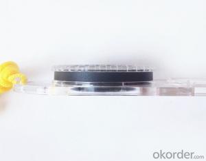


Professional Map or Ruler Mini-Compass DC47-2
- Ref Price:
-

- Loading Port:
- Tianjin
- Payment Terms:
- TT OR LC
- Min Order Qty:
- 20 pc
- Supply Capability:
- 10000 pc/month
OKorder Service Pledge
OKorder Financial Service
You Might Also Like


Features of DC47-2
1, professional usage: orientation, distance measuring, measuring slope, azimuth and pitching Angle measurement, drawing, a magnifying glass
2, high quality compass with neck rope, portable and rugged
3, ACRYLIC material, about 2mm thick
4, Damping Dial: to keep the stability of the pointer, more suitable for outdoor environment.
5, Accuracy: accurate and clear, there were 360 degrees azimuth Angle, outer ring is 64-00 system, Liquid filled in the compass for reliable readings.
6, Magnifier function
5,ruler compass,
6,for map measure and drawing
7,one meter neck rope,
8,Liquid filled in the compass for reliable readings,
9, magnifier function.
Product details of DC47-2
Model: DC47-2
Name: Professional map compass, ruler compass
Product Origin: China
Supply Ability: 10,000 pcs/month
Minimum Order: 20 pcs
MOQ for OEM package: 500pcs
Product Size: 125.5*60.5*10 (mm)
- Q:Want to buy handheld GPS in Hongkong, I would like to ask what brand is better, the specific model? Where to buy? How much is the price? In the mainland can be used? More questions, thank you!
- Basically what questions are like this, there are few domestic brands, low precision did not see any big price advantage, but high precision or cheaper than abroad, you belong to the individual leisure estimates do not need to read.
- Q:How to set the handheld GPS related parameters and coordinate conversion parameters throughout the country
- Two. To coordinate the coordinate data of the control points obtained provide technical support unit of Beijing Unistrong companies around the branch responsible person to calculate the coordinate transformation parameters conversion parameters, or to obtain their own conversion conversion software. After the conversion parameters are calculated by the prompt input handheld GPS. Only after such a setup, after all the soil in the region when the coordinates of the GPS read out the coordinates of the point for the Beijing 54 coordinates.
- Q:Is it accurate to measure highway mileage with GPS handheld
- Measuring mileage, since the unit has been upgraded to the inside, it is quite accurate oh
- Q:I am a handheld GPS precision is low, how to use to be able to improve certain accuracy.
- If the carrier phase measurement function is not available, you have the maximum accuracy of GPS accuracy of 1-10This can only improve the observation environment using SBAS and other ways to improve the accuracy
- Q:How about the accuracy of the GPS handset?
- zhonghaida Qmini series: 3 meters; zhonghaida Qcool series: 5 meters; precision and price is proportional to the precision is higher, the higher the price.
- Q:Hand held GPS coordinate conversion method
- Three parameter test DX, DY, DZ, DA, DF after the conversion parameters of the five, must be prompted to enter the handheld GPS, while the input area of the central meridian longitude. E on behalf of the east longitude, projection ratio of 1, the deviation of things to the north and south of the deviation of 0, and set the unit for M. Enter these parameters, should be taken to the field test, check whether these five parameters are correct. The method is selected, vision, GPS receiving signal strength of the feature points in the field (such as linear object intersections, independent features, etc.) is the best stone control points were measured and compared with theory and find out the coordinates of these points. If the results of the comparison exceed the nominal accuracy of the instrument, the conversion parameters or the problems that should be found should be recalculated.
- Q:Handheld GPS charge is not into electricity what is the reason
- Reason analysis:1, battery damage. 2, system failure. 3, charger reasons or bad contact.
- Q:I bought the way k20s, this handheld GPS how
- Choi way handheld GPS feel that you can also be in the last year, the Zhengzhou Bureau of Surveying and mapping seems to be called the wide Han instrument that home to buy, so there is no problem with it, the price is not expensive.
- Q:How to use the handheld GPS whole watershed investigation
- Therefore, it is an important method to solve the maximum value in physics by solving the maximum and minimum values of the physical quantity by the critical state.
- Q:Fuxin coordinates with the mapping of the seven parameters are what ah there is no professional knowledge to tell my brother I need to fill the gps... Thanks.
- Handheld GPS has not been used, you can find three known control points, try to solve.
1. Manufacturer Overview |
|
|---|---|
| Location | |
| Year Established | |
| Annual Output Value | |
| Main Markets | |
| Company Certifications | |
2. Manufacturer Certificates |
|
|---|---|
| a) Certification Name | |
| Range | |
| Reference | |
| Validity Period | |
3. Manufacturer Capability |
|
|---|---|
| a)Trade Capacity | |
| Nearest Port | |
| Export Percentage | |
| No.of Employees in Trade Department | |
| Language Spoken: | |
| b)Factory Information | |
| Factory Size: | |
| No. of Production Lines | |
| Contract Manufacturing | |
| Product Price Range | |
Send your message to us
Professional Map or Ruler Mini-Compass DC47-2
- Ref Price:
-
- Loading Port:
- Tianjin
- Payment Terms:
- TT OR LC
- Min Order Qty:
- 20 pc
- Supply Capability:
- 10000 pc/month
OKorder Service Pledge
OKorder Financial Service
Similar products


New products


Hot products


