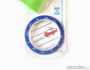


Professional Map or Ruler Mini-Compass DC35F for Surveying
- Ref Price:
-

- Loading Port:
- Tianjin
- Payment Terms:
- TT OR LC
- Min Order Qty:
- 20 pc
- Supply Capability:
- 10000 pc/month
OKorder Service Pledge
OKorder Financial Service
You Might Also Like


Model: DC35F
Name: Professional map compass, ruler compass
Product Origin: China
Supply Ability: 10,000 pcs/month
Minimum Order: 20 pcs
MOQ for OEM package: 500pcs
Product Size: 128*60*16 (mm)
Features of DC35F
1, professional usage: orientation, distance measuring, measuring slope, azimuth and pitching Angle measurement, drawing, a magnifying glass
2, high quality compass with neck rope, portable and rugged
3, ACRYLIC material, about 2mm thick
4, Damping Dial: to keep the stability of the pointer, more suitable for outdoor environment.
5, Accuracy: accurate and clear, there were 360 degrees azimuth Angle, outer ring is 64-00 system, Liquid filled in the compass for reliable readings.
6, Magnifier function
5,ruler compass,
6,for map measure and drawing
7,one meter neck rope,
8,Liquid filled in the compass for reliable readings,
9, magnifier function.
- Q:What is the difference between professional GPS handsets and mobile navigation?
- First of all, if used outdoors, then fell, and so on are likely to water, and this thing is also very expensive, so the opportunity to have a high professional anti shock waterproof performance. You can see the Challenger I tour the next 600, three well plates.
- Q:Handheld GPS how to achieve decimeter
- Look at the handheld chip, and some can be directly achieved, some with differential signals to
- Q:How do I still stay in the GPS navigation, GPS monitoring of the primary idea? FiveBusiness services, thank you!Future business services
- 6 people travel and adventure7 personal communication terminal (with mobile phones, PDA, electronic map integration)8 time synchronization of electric power, post and telecommunication9 accurate timing of admission10 accurate frequency of admission
- Q:Handheld GPS navigation is what? Where to buy handheld GPS navigation, how to select GPS navigation?
- Handheld GPS is mainly for GIS data acquisition, a lot of advanced GPS with PDA function, you can load navigation software for vehicle navigationBut the handheld GPS is mainly to do some engineering design, the main area can be measured, the location, and the boundary survey. GPS can do advanced vehicle navigation can also waypoint navigation, is a coordinate input to precise navigation to this position.Handheld GPS navigation is divided into 2 kinds, one is portable GPS navigation, one is used for surveying and mapping professional GPS handheld
- Q:Is it accurate to measure highway mileage with GPS handheld
- Measuring mileage, since the unit has been upgraded to the inside, it is quite accurate oh
- Q:Seeking the similarities and differences between RTK and GPS
- RTK full name is GPS-RTK real-time dynamic distribution, which you know.
- Q:What is the difference between a hand-held GPS and a car's onboard navigator
- Effect of GPS navigation handheld as vehicle, as the vehicle with what map, the hand-held GPS is mainly used for point positioning, measuring area, high precision, good anti 3, my understanding is that
- Q:Professional handheld GPS GARMIN (DR) how to use
- Would like to use the function of handheld GPS purposes, the measurement of soil area, linear navigation, auxiliary fishing waypoint navigation point information, traffic data display, etc.
- Q:Handheld GPS and mobile phone GPS what is the difference?
- The same: GPS main chip may be the same; can complete the GPS positioning;
- Q:Jia Ming etre20 handheld GPS good
- Jia Ming ETREX20 compact portable, solid and rigorous work design, precise positioning, functional improvement, for out of work, travel friends can be used as a reference.
1. Manufacturer Overview |
|
|---|---|
| Location | |
| Year Established | |
| Annual Output Value | |
| Main Markets | |
| Company Certifications | |
2. Manufacturer Certificates |
|
|---|---|
| a) Certification Name | |
| Range | |
| Reference | |
| Validity Period | |
3. Manufacturer Capability |
|
|---|---|
| a)Trade Capacity | |
| Nearest Port | |
| Export Percentage | |
| No.of Employees in Trade Department | |
| Language Spoken: | |
| b)Factory Information | |
| Factory Size: | |
| No. of Production Lines | |
| Contract Manufacturing | |
| Product Price Range | |
Send your message to us
Professional Map or Ruler Mini-Compass DC35F for Surveying
- Ref Price:
-
- Loading Port:
- Tianjin
- Payment Terms:
- TT OR LC
- Min Order Qty:
- 20 pc
- Supply Capability:
- 10000 pc/month
OKorder Service Pledge
OKorder Financial Service
Similar products


New products


Hot products


